|
Barnard
Castle to Cotherstone
|
Starting
point and OS Grid reference:

Lay-by
on the B 6277, just over half a mile NW of Barnard Castle (NZ 037169).
|
Ordnance
Survey Map
OL31
North Pennines – Teesdale & Weardale.
Buy this map from
List
of OS Maps
Note: If you use OS Maps on-line, you can download this route via this
link.
| |
Distance: 8.2 miles
|
Date of Walk: 29
September 2014
| |
Traffic light rating:

(For explanation see My
Walks page)
| |


For advice on .gpx files see
My
Walks page
|

Click
the PDF logo above to give a printable version of this walk without the
photos.
|
To
view route as a dynamic Ordnance Survey map click here.
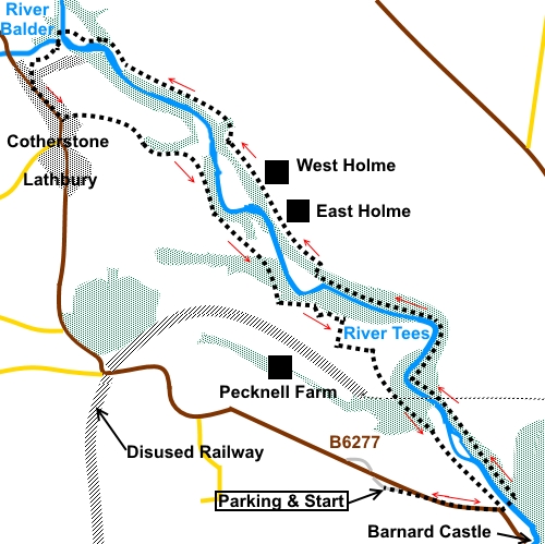
Introduction:
This walk from Barnard Castle to
Cotherstone in the main follows
the Teesdale Way. This broadly follows the River Tees although when the
trees are in leaf, you do not actually see a great deal of the river. It is
a pleasant walk with a few ups and downs but is mostly straightforward and
well marked with Teesdale Way arrows and fingerposts. It is a mixture of
fields and forest walking.
Cotherstone is an
attractive village with a green and the Fox and Hounds pub, which dates back
to the 1750s, overlooks this. I can recommend a lunch stop there. The
village has been designated as a conservation area to preserve its
character.
A castle, marked on the OS
map, was built in Cotherstone in the eleventh century but nothing of this
remains apart from a vague mound of earth.
The walk starts from either
of two lay-byes (opposite each other) on the B 6277, just over half a mile
to the north west of Barnard Castle (NZ 037169) and just past the Caravan
Club site. Although there is about half a mile of walking along the quite
busy B6277, there is a wide verge with a clear path in places. You could
also start from Barnard Castle itself, though there would be little
difference in the distance walked. There is some parking near the castle but
no free, unlimited parking in the town centre. There are also some
residential streets to the back of the Castle.
Start:
From the lay-by parking on the B 6277, walk back towards Barnard Castle for
half a mile. Just before the narrow road bridge over Deepdale Beck, turn
left following the fingerpost for Cycle Trail and Barnard Castle and cross
what is known locally as the Silver Bridge (or obvious reasons) over the
River Tees. There are good views of the castle in Barnard Castle from here,
along the river.
%20View%20from%20Silver%20Bridge.jpg)
Once over the Silver
Bridge, turn left following the fingerpost for “Teesdale Way” and
“Cotherstone 3½ miles”. There is an information board at this point
which tells you something about the history of Flatts Wood.
%20Silver%20Bridge.jpg)
There is little more to the
directions for a while. Just follow the path closest to the river, through
the woods. After about half a mile, you come to a split in the path where
the right hand branch climbs some steps to the remains of the Tees Viaduct.
It is an impressive structure, with some immaculate stonework but with
little other interest. It was built in 1860 to carry the South Durham and
Lancashire Union Railway over the Tees. The main bridge was demolished in
1971. Return to the main path afterwards.
%20Remains%20of%20Tees%20viaduct.jpg)
When the path opens into a
field, follow the right hand boundary wall. Part way along the boundary, go
through a walkers’ gate into the woods once more and the path climbs quite
steeply, through the woods, to another walkers’ gate at the top of the
slope, into a field. Turn left, following a Teesdale Way arrow.
%20Rapids%20on%20the%20Tees.jpg)
The route now follows the
upper edge of the woods.
You pass a short distance
from two, white painted, farmhouses (East and West Holme Houses) and at the
second, cross a ladder stile into a field. At the end of the next field,
there is a gate with a “private” sign and depending on the light, it is
easy to miss the stile in the gloomy corner alongside. Continue to follow
the line of the woods.
%20Pleasant%20country%20scene.jpg)
The path enters a more open
field (NZ 025196), after a short section in the woods, crossing a stream by
a footbridge. Go through a slit stile and head for the right hand corner of
the woods ahead then resume following the edge of the trees.
%20View%20NW.jpg)
%20View%20of%20the%20Tees.jpg)
Turn left through a
walkers’ gate into the woods again (NZ 017200), following the Teesdale Way
arrow. The path drops down and out of the trees to a more level, open area
by the river. Follow the obvious track towards a two way fingerpost but just
before it, turn left across a footbridge, over the River Tees.
%20Bridge%20at%20Cotherstone.jpg)
Once over the bridge, turn
left, following one of the Teesdale Way fingerposts.
Cross a second footbridge,
over the River Balder, then turn right up a tarmac lane to the village of
Cotherstone. At the ‘T’ junction, the Fox and Hounds faces you across
the village green and is worth a refreshment stop!
Otherwise, turn left at the
‘T’ junction (or right after coming out of the pub) and walk along the
main road through the village.
Opposite Cotherstone
Primary School, turn left down a stony lane (NZ 013196) Stay on this lane
ignoring any turns off until, as it turns sharply left over a cattle grid,
you bear off right down a narrow footpath.
After crossing a stream,
the path curves left, following the left hand boundary of the field.
Through the next gate,
follow the right hand boundary of the field. As you near the dwelling, turn
right through a kissing gate (the path has been diverted). Just beyond the
property, go through another kissing gate.
After the next stile,
follow the path as it curves left between two walls. The path goes through a
pine forest before opening into a field. The continuation gate is visible.
On reaching a farm (Towler
Hill) (NZ 036178) turn right on the drive. As the drive bends slightly
right, turn left, over a stile, following the Teesdale Way sign.
After going through woods,
come out on to a tarmac lane and turn left (NZ 040174). The lane brings you
out on the B 6277, yards from the path where you started. Turn right back to
the lay-by.
If you need to buy any
hiking equipment/clothing before your trip see the Hiking
Store
All information on this
site is given in good faith and no liability is accepted in respect of any
damage, loss or injury which might result from acting on it.
|


.jpg)
.jpg)
.jpg)