
|
|
|
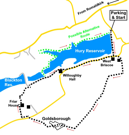
To view route as a dynamic Ordnance Survey map click here. Introduction: This walk is set in Baldersdale, an offshoot of the main Teesdale valley. Unsurprisingly, the Dale is home the River Balder which was dammed in the late nineteenth century to create Hury, Blackton reservoirs, with Balderhead reservoir following in 1965. They supply Teeside and Middlesborough. The route takes you over Cotherstone Moor to Goldsborough, one of several’ Table Mountains’ in the area, with a flat plateau rising to 1276ft (389m) from which there are great long distance views. On a clear day, you can see the North York Moors and of course the reservoirs. The southern side of the hill is flanked by a series of gritstone outcrops, popular with climbers. Goldsborough is believed to have been the site of an Iron Age fort. Given the stone buttresses and high plateau relative to the surrounding land, one can imagine it would have been easy to defend. There are reputedly some cup and ring markings but I did not hunt for them. The approach to the hill is bleak moorland exposed to the weather. It can be boggy in places. It crosses extensive Access Land which means people have probably wandered fairly widely meaning clear footpaths are not necessarily clear on the ground, where they appear on the map, providing a navigational challenge. However, as long as you can see the hill, navigation is not that difficult and I think I have described a reasonably easy to follow route. Once you start to come off the hill, you join the Pennine Way so navigation becomes that bit easier. There are no particularly steep sections so I have graded it as ‘green’. The walk starts from a car park at Hury Reservoir, at the north end of the dam. To get there, turn off the B6277 just south of Romaldkirk, following the road sign for Baldersdale, Hury and Hunderthwaite plus a brown tourist sign for ‘Reservoirs’. Follow the road for just over two and a quarter miles. Turn left down a narrow lane to the reservoir. Start: From the car park, walk across the dam. Cross the car park at the other end of the dam and turn left along the lane, only for a hundred yards or so. As the road turns sharply left, turn right to follow a public footpath fingerpost for “1 West Briscoe”
As you get almost to the house, turn left through a walker’s gate marked with a yellow arrow and follow the broad track round the property. Go through a metal farm gate following the direction of the yellow arrow. Cross a stream via a stone slab bridge. Pass to the left of a fenced off enclosure and head for the gate, where you enter the Access Land. Just after going through the gate, at a crossroads of paths, turn right (NY 969188). This is where you leave the map marked footpaths (there was no evidence of them when I did the walk!).
Follow the wall along for less than a quarter of a mile and look out for a spot where the wall kinks away from you in a ‘V’ shape, where there is a gate. Turn left here along a broad track, heading uphill (NY 966188). Reach a boggy area at NY 964183. There was a bridge here but the boggy area had extended to put it out of reach. (There had been a lot of recent rain). I arced round it anti-clockwise without much difficulty, to rejoin the path.
The path does peter out in places but you can see the continuation on the hill ahead, until it becomes spasmodic once again. However, there is a watercourse on the left marked with a long line of the typical stiff grass found on heathland. Continue following that line. Meet a clear path crossing your route at NY 958176 and turn right heading for Goldsborough.
Once on the plateau, follow the main path. I found a sheltered spot in the sun against the rocks at NY 953177 for a snack.
As you descend from the plateau, you will come across a post with a blue arrow marking the Pennine Way. Follow the obvious path, heading towards another post ahead. Just after this second post, the path splits. Take the left hand path. Follow this down to the road and turn left for about a hundred yards, then right to follow a Pennine Way fingerpost to East Friar House Look out for a walker’s gate to the left of the farmhouse marked with a yellow arrow and a white acorn for the Pennine Way. Keep to the left of the barn and once through the second gate, turn right behind the barn and then curve left heading for a gateway at the bottom of the field. Once through the gateway, head for another to the left of the barn and continue straight ahead in the direction of the barn wall to the far side of the field to cross a stile. Keep straight ahead to a stone step stile and turn left after that to a stile in the bottom right hand corner of the next field. Cross and turn right along a broad track. You will pass what looks like a small reservoir, though it is actually part of Hury reservoir. I believe you can cross over the reservoir if you wish and return to the car park along the north shore of Hury reservoir. Unfortunately, I was unaware of this, so continued along the track and then road to the south of the reservoir, to re-cross the dam back to the car park.
If you need to buy any hiking equipment/clothing before your trip see the Hiking Store All information on this site is given in good faith and no liability is accepted in respect of any damage, loss or injury which might result from acting on it.
| | |||||||||||||||||

.jpg)
.jpg)
.jpg)
%20Hury%20Reservoir.jpg)
%20Hury%20Reservoir%20with%20its%20castellated%20control%20tower.jpg)
%20Goldsborough.jpg)
%20View%20North%20during%20the%20ascent.jpg)
%20Looking%20back%20to%20West%20Briscoe%20along%20the%20track.jpg)
%20Crag%20at%20the%20end%20of%20Goldsborough.jpg)
%20Flat%20plateau%20of%20Goldsborough.jpg)
%20View%20from%20Goldsborough.jpg)
%20Dam%20dividing%20Hury%20reservoir.jpg)