
|
|
|
To view route as a dynamic Ordnance Survey map click here. Introduction: This easy walk from Mickleton to Middleton-in-Teesdale could be done from either place as it is a circular walk but I recommend doing it from Mickleton because Middleton is a delightful place to wander through in the middle of the walk and there are many refreshment opportunities, should you be seeking sustenance. I can recommend the Forrester’s Arms! Equally, should you decide to walk from Middleton, the Blacksmith’s Arms in Mickleton is a real find with pizzas to die for. However, check the opening times, as when I visited it (on a different day!), it did not open until 3.00pm. The walk is very straightforward and navigation is simple. You can return directly via the river Tees from Middleton but the route I describe gives you a little more elevation soon after Middleton, with nice views along the valley, before dropping gently down to the river. Middleton-in-Teesdale
is a small market town and the main one in the Upper Teesdale Area. It came
into its own from the early 19th Century when the London Lead
Company moved its main headquarters there. It was responsible for many of
the buildings. In September 1877, an elaborate fountain was unveiled to
honour Robert Walton Bainbridge, superintendent of the London Lead Mining
Company. Middleton-in-Teesdale was also the
terminus of the railway, opened in 1868, from Barnard Castle, until the
Beeching axe fell in 1964. Its disused route now forms the first part of
this walk. There are a number of independent
shops in Middleton and the town has a pleasant friendly feel to it. Mickleton is a small pleasant
village with one unusual aspect in that it (amongst other land) is the
subject of a 1000 year lease between the Bowes family and four local yeomen
farmers. This enabled the Bowes family to raise capital of some £1570, in
1607, which the Bank of England calculator says would be the equivalent of £473,182
in 2020. What happens when the lease expires is anybody’s guess but as
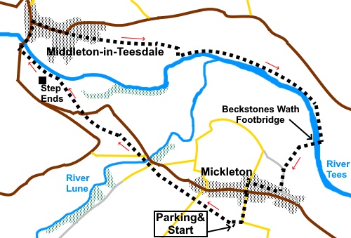
this is not until 2607, not many of us need to worry about it! The walk starts from a free car park on the Tees Railway walk at Mickleton. To get there, take the B6277 from Barnard Castle. Pass through Cotherstone and Romaldkirk. Mickleton is next. Turn left opposite the Blacksmith’s Arms, following the tourist sign for Tees Railway Walk, Mickleton Station 300 yards. As the lane bends left, the entrance is straight ahead and clearly marked. There is parking for several cars and picnic tables. Start: Leave the car park and turn right along the course of the old railway. Stay on the old railway route, passing under a road bridge and crossing a viaduct over the river Lune. Continue until you reach two concrete step stiles on either side. Cross the right hand stile, indicated by a sign indicating it is the way to Middleton-in-Teesdale (NY 954244 ).
Cross straight over the farm drive to a walkers’ gate, then immediately through a slit stile to the road. Take care here as this can be quite a busy road with fast traffic. Walk left along the road for only a few yards, then turn right following a fingerpost over a step stile. Follow the well trodden path to the far left hand corner of the field. Cross a step stile and continue in the same direction to another then follow the obvious route to join a broad track alongside the river. When you get to the tarmac access drive to Steps End Farm, turn right and at the road, right again into Middleton (NY 946251). It is better to cross the road immediately, to the pavement opposite, as there is none on the right hand side, as you go over the river bridge.
Once over the river bridge, you can turn immediately right to follow the left hand bank of the River Tees, back to Mickleton, following the fingerpost for “Tees Valley and Embleton 4 miles” but it would be a shame not to look round this delightful town. On that basis, walk along the road, up the hill and at the ‘T’ junction, turn right. Walk down the main street.
Where the road bends left, fork off to the right, along Leekworth Gardens (NY 951253).The turn is just after Middleton Nursery and Primary School. Follow Leekworth Gardens along until it bends sharply left, then go straight ahead, along a gravel track, passing a number of bungalows and following a public footpath fingerpost. As the track bends sharply left, keep straight ahead over a stone stile. Keep to the top side of the field, crossing the obvious stiles.
At NY 960252 come to a post with yellow arrows pointing left and straight ahead. Keep straight ahead. There are good views along the valley here, as you pass a large caravan site on the other side of the river. As you get to the trees, turn right to follow the path down towards the river (NY 962252). After passing a redundant stile, the path forks. Keep left, passing a bench, descending some rough steps, to follow a path along the river bank.
The path divides just before a barn. Take the right hand fork. Continue until you reach a long footbridge (Beckstones Wath Footbridge, opened in 2002) and cross, to then follow the obvious path straight ahead through the field.
Go through a gate in the far right hand corner of the field and follow the broad track round to the left, to join a lane where you turn left along it. At the ‘T’ junction, just in front of some garages, turn right. At another ‘T’ junction, turn left up the hill to Mickleton’s main street, where you turn left and quickly right opposite the Blacksmith’s Arms to return to the car park.
If you need to buy any hiking equipment/clothing before your trip see the Hiking Store All information on this site is given in good faith and no liability is accepted in respect of any damage, loss or injury which might result from acting on it.
| | |||||||||||||||||

.jpg)
.jpg)
.jpg)
%20View%20across%20the%20valley%20near%20the%20start%20of%20the%20walk.jpg)
%20Looking%20along%20the%20old%20railway%20route.jpg)
%20River%20Lune%20from%20the%20viaduct.jpg)
%20View%20to%20up%20Teesdale%20to%20Hardberry%20Hill.jpg)
%20Distinctive%20barn%20at%20Step%20Ends%20Farm.jpg)
%20River%20Tees.jpg)
%20Memorial%20Fountain.jpg)
%20Centre%20of%20Middl;eton%20in%20Teesdale.jpg)
%20View%20South%20over%20the%20Tees%20Valley.jpg)
%20Tranquility%20on%20the%20river%20Tees.jpg)
%20Boundary%20marker%20on%20the%20Teesdale%20Way.jpg)
%20Looking%20along%20the%20River%20Tees.jpg)
%20Beckstones%20Wath%20Footbridge.jpg)
%20View%20to%20Mickleton.jpg)
%20Blacksmith's%20Arms%20Mickleton.jpg)