
|
|
|
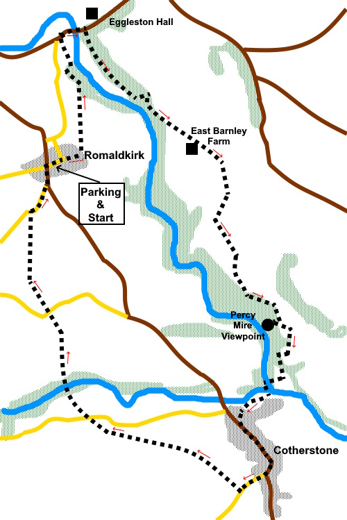
To view route as a dynamic Ordnance Survey map click here. Introduction: This is an easy walk from the pretty village of Romaldkirk, complete with village green and pump and amazing church to Cotherstone. There are some lovely views along the way, not least of Egglestone Hall, where you can visit the café and gardens if you wish (check website for opening times). You
pass the dilapidated Egglestone
Cricket Pavilion by the Haugh (a low-lying often alluvial riverside meadow)
built by the late Sir William Gray. The Club ceased in 1999 due to falling
membership. At Cotherstone you arrive by the
river where there is a great, peaceful picnic spot by the river with two
benches. There is not too much to see in
Cotherstone itself. Both Cotherstone and Romaldkirk
were in the North Riding of Yorkshire until 1974m when they were
‘nicked’ for County Durham! The walk starts from Romaldkirk which lies on the B6277 approximately five and a half miles north west of Barnard Castle. Start: With the village green on your right and the church on your left (NY 996221), walk down the road and turn left following a public footpath fingerpost for the “Teesdale Way and Egglestone 1¼ miles”. The path is a walled path at this point. Cross a stream over a two plank bridge then a stone step stile into the field and follow the yellow direction arrow, towards a power pole by a wall. Keep to the right of this, to cross a step stile a few yards further on. Follow the right hand boundary. It becomes a block wall. Continue to follow this including after a stile. When the wall ends, continue to follow the right hand boundary.
When the field drops steeply down banking, stay following the top of the banking until you reach the obvious place where the footpath descends.
The road bridge ahead is your destination to cross the river (NY 997232).
A few yards after crossing the river, turn right following a fingerpost for the “Teesdale Way and Cotherstone 2½ miles”. Follow the broad drive until you reach a gate marked private (NZ 002227). Turn left here following the yellow footpath arrow for the Teesdale Way, climbing through the trees.
Exit the woods through a walkers’ gate and follow the obvious path parallel with the right hand boundary. After crossing a stream down steep banking in the centre of the field, the path veers away left. As you get to the brow of the hill, you will see a stone step stile. Cross this and head to the diagonally opposite corner of the field. There was a trodden path visible when I did the walk. Cross a stile and follow the right hand boundary passing a small stone barn (NZ 007223). Pass East Barnley farm then heading slightly left to a gateway ahead. Once through it, continue slightly right following the yellow footpath arrow for the Teesdale Way, an obvious path bearing right. Through a walkers’ gate, cross a small stream. The direction arrow indicates straight ahead but I would say bear slightly right. As you crest the brow of the hill, you can see a gate and finger post ahead. Go thorough that gate and head slightly left to a fingerpost ahead, where you cross a stile. Bear left and follow the fence along. After going through a gate, follow the yellow arrow along the outside of the woods.
Keep following the woods until you reach a point where the woods are set back on the right. Here is Percy Mire viewpoint (NZ 014207), should you wish to visit (in pouring rain I did not!). It is a rocky cliff named after a Lord Percy allegedly fell to his death on horseback whilst hunting. There are supposed to be fantastic views over the Tees. Otherwise continue across the grassy field. At the end of the field, drop down to cross a stream and immediately turn right over a stone step stile. There is a pleasant little waterfall on the right. Follow the obvious path. It leads down to a caravan site. At the site, go straight across the drive and through a gate with a yellow arrow. The track descends to a field and splits. Keep right to a footbridge which you cross and turn left for Cotherstone. Turn left over a second footbridge. There are a couple of benches in a pleasant spot by the river, should you want a picnic.
Follow the path to Cotherstone village. The path joins a lane. Keep climbing until you reach the main street. There actually a couple of footpaths more or less straight ahead which will take you to the old railway line which is your return path to Romaldkirk but I chose to wander through the village and see the church. If you follow my route, turn left along the main road. Turn right along the road signposted for “Bowes 4 miles”. Pass St Cuthbert’s Church and not far after the National speed limit sign, turn right through a walkers’ gate along the old railway. You will cross one road at NY 998199, a viaduct over the River Balder at NY 996202 and another road at NY 994208. At the next road (NY 993217) turn right back into Romaldkirk. If you need to buy any hiking equipment/clothing before your trip see the Hiking Store All information on this site is given in good faith and no liability is accepted in respect of any damage, loss or injury which might result from acting on it.
| | |||||||||||||||||

.jpg)
.jpg)
.jpg)
%20View%20north%20over%20the%20Tees%20Valley%20to%20Middleton%20Common.jpg)
%20Eggleston%20Hall%20and%20Eggleston%20Bridge.jpg)
%20Looking%20along%20the%20Tees%20from%20Eggleston%20Bridge.jpg)
%20Old%20cricket%20pavillion%20near%20Eggleston.jpg)
%20Stream%20by%20the%20footpath.jpg)
%20Rocky%20outcrop%20in%20the%20woods.jpg)
%20Looking%20up%20Teesdale%20from%20Shipley%20Wood.jpg)
%20Another%20view%20near%20Shipley%20Wood.jpg)
%20By%20the%20River%20Tees%20near%20Cotherstone.jpg)