
|
|
|
To view route as a dynamic Ordnance Survey map click here. Introduction: Although I have called this walk Boscastle to Bossiney Haven, really to define the furthest points, there is so much more to it. It is full of interesting features and a great walk. A brief list is:
Boscastle is best left to the end of the walk. It is a very pretty setting with a river flowing down it. Sadly, the river was almost the end of Boscastle, when there was a severe flood in 2014. However, strenuous efforts mean there is no trace of the destruction now and one could be forgiven for thing nothing happened. St Nectan’s Glen provides a lovely walk through attractive woodlands. These are privately owned and although the public footpath runs through them, this does not unfortunately include the waterfalls area. To see these you have to pay at the café. Whether this is worth the cost is up to you – potentially £5.95 per adult, or £4.70 (2016 prices) for coffin dodgers like me! However, having bitten the bullet and paid up, I thought it was worth it as the main waterfall particularly is amazing. For the best view, you have to “paddle”. I had walking boots on so no problem but wellington boots are provided for others. The coffee was brilliant too. St
Piran’s Church first appeared in records in 1457. At some point, it ceased
to be a church and was used as a farm building until 1941 when it became a
church once more. The well is adjacent. The
ancient rock carvings are carved into a vertical rock next to a ruined mill.
These are estimated to be Bronze Age, dating from 1800 to 1400 BC and are in
very good condition. Rocky
Valley, under the care of the National Trust, is a spectacular chasm,
recognised as important for a variety of reasons, not least for having at
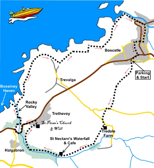
least 161 species of mosses. The site of the Iron Age fort is marked by an information board which tells you all about it with pictorial representations as to how it might have looked. The walk starts from Paradise Road, where there is a reasonably wide section for safe parking, immediately off the B3266 on the western side of Boscastle Start: Walking away from the B3266, where Paradise Road bends left, take the broad track signed for Trerosewill Farmhouse. (SX 096905) Stay on this broad track, passing the farmhouse, as it bends right, then left. Immediately after the left bend, within ten yards, take a stone stile on the right (there is a blue splash of paint on its left hand side) (SX 096902). Follow the path uphill, to another stile which you should be able to see. Good views of the coast open up behind you.
Over the stile, continue in the same direction. The pasture was a little rough when I did the walk but the route was clear and well trodden. Cross a small bridge over a stream and in the next field, follow the left hand boundary. As you round a corner, head for the gate at the top of the field. Through this gate, turn immediately left, to cross a couple of stiles and a small bridge, marked with yellow arrows. Almost immediately, a yellow arrow on a post directs you to the crown of the field. As you get to the crown, you will see a farm gate with a walkers’ gate along side (SX 093897). From the gate, bear left following the yellow footpath arrow. Opposite the gate is a broad hedged track. Be sure to walk along this and not to the right or the hedge as there is no exit from the field. The footpath arrow is a little misleading. At the lane (SX 092895), turn right and just round the bend, turn left to follow a public footpath fingerpost. Once over the stile, head for the diagonally opposite corner of the field. Note, you cannot actually see the opposite corner until you get to the crown of the field. At another lane. turn left and walk along the lane, ignoring a footpath immediately off to the left.
At Tredole Farmhouse, turn right (SX 091892), following a public footpath sign for “St Nectarn’s Glen 1 mile”. Once past the dwellings, keep straight ahead on the descending broad track. At the end of the track, cross a stile and bear diagonally right across the middle of the field. Once you get to the crown of the field, you will see a stile indicating the continuation of the route. Over the stile, head down the track towards the woods, soon coming to another footpath marker post. Ignore the left turn and continue straight ahead. Pass the remains of an old house with a strangely isolated fireplace.
At the bottom of the track, you meet a stream (SX 088887). This is the one which flows down St Nectan’s Glen and you now follow this, on its right hand side for some distance. A mixture of stiles, markers and well trodden track make it easy to follow. You come to a café/shop and here is the entrance to St. Nectan’s Waterfall. You do not have to pay to see it but it is quite a spectacle. Whatever you decide, the route continues downstream to a bridge and a three way fingerpost.
Here, you have to decide whether to follow my path or turn left to Halgabron. Diverting to Halgabron, then turning right to following the lane down to the B3266 road and crossing straight over to the path to Rocky Valley, means you avoid a somewhat unpleasant walk along this rather busy road. However, this misses out St Piran’s Church and well. Your choice! My choice was to follow the broad track indicated by the finger post for “St Pirans Well and Trethevey”. The track gradually turns away from the stream and joins a tarmac lane which you follow to the church and well.
At the B3266 (SX 076893) turn left and walk along it for just under half a mile. You can miss a bit of the road by walking through the waterfall car park. After rounding a sharp left and right hand bend, turn right to follow the fingerpost for “Public Footpath to the Coast Path via Rocky Valley” (SX 072891). This is also the entrance to Trevillet Mills. Pass a ruined mill where, if you look at the rocks on the right, you will see prehistoric carvings.
Rocky Valley is quite a spectacle where the stream reaches the sea. Our main route continues right, over the bridge (SX 072895), to follow the Coast Path. However first, it is worth turning left for the brief climb to the cliff top, for the view over to Bossiney Haven. This is a lovely bay and there is a handy bench for lunch.
Return to and cross the footbridge and follow the Coast Path back to Boscastle.
At SX 062898, there is an old white lookout building and the site of an ancient Iron Age fort, with a ditch and bank, the remains of its ramparts. Follow the path round into Boscastle. There is an upper and lower level path but either will do as they meet at the footbridge over the river.
From Boscastle, take the road to the right of the Wellington Hotel. Opposite Ivy Cottage, take a short right turn uphill to the main road into Boscastle and go straight over up Forrabury Hill. Turn first left to the main B6266, then right along the pavement back to Paradise Road. If you need to buy any hiking equipment/clothing before your trip see the Hiking Store All information on this site is given in good faith and no liability is accepted in respect of any damage, loss or injury which might result from acting on it.
| | |||||||||||||||

.jpg)
.jpg)
.jpg)
%20View%20over%20Boscastle.jpg)
%20True%20craftsmanship%20woodstore.jpg)
%20Lonely%20Fireplace.jpg)
%20St%20Nectarns%20Waterfall.jpg)
%20St%20Nectarns%20Waterfall%20(Bottom).jpg)
%20St%20Nectarns%20Glen%20woodland.jpg)
%20Inside%20St%20Pirans%20church.jpg)
%20St%20Pirans%20Well.jpg)
%20Bronze%20Age%20rock%20carving.jpg)
%20Rocky%20Valley.jpg)
%20Bay%20at%20Bossiney%20Haven.jpg)
%20Coast%20view.jpg)
%20Lookout.jpg)
%20Boscastle.jpg)
%20Boscastle%20Harbour.jpg)