
|
|
|
To view route as a dynamic Ordnance Survey map click here. Introduction: This very easy circular walk from the village of
Bempton in East Yorkshire barely needs any directions as it is virtually
self explanatory. It is also almost as level as you could get. Bempton
is a quiet little village best known because of its association with the
Royal Society for the Protection of Birds (RSPB) centre above the chalk
white 400ft cliffs. The cliffs are a magnet for bird watchers, particularly
between March and August when something in the order of half a million
seabirds nest. There is a café and toilets at the centre. At
the crossroads in the village centre is the White Horse pub which is unusual
in having a blue tiled roof. The
walk passes St. Michael’s Church, the oldest parts of which date to around
1200. There
was a medieval village of Newsham on the edge of the current village and
remains of Bronze Age dwellings have been found in the area. On
the cliff section, you will pass the remains of an old RAF station, set up
to provide radar warning in World War II. It continues in one way or another
until it closed in 1972. There is not much to see and entrances to the
bunker have been sealed. Buckton
Village, through which you pass on the return journey merges with Bempton.
It has an attractive pond. There
are several benches on the cliff tops for a pleasant picnic
break. The
walk starts from Newsham Hill Lane where there is some on-street parking
between the level crossing and the village centre. There is also a railway
station. To get Bempton by car, it lies on the B1229, between Flamborough
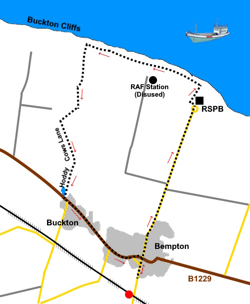
and Filey (closer to Flamborough). Start: From Newsham Hill Lane (TA 191720), head towards the centre of Bempton, along Church Lane. At the junction with High Street, head more or less straight across, to the right of the White Horse pub, along Cliff Lane. There is a signpost for Bempton Cliffs.
Continue
along the road for just over a mile, to the edge of the RSPB nature reserve
and follow as it curves left, in the
direction of a public footpath fingerpost. Go through some double gates into the overflow car park, then turn immediately right to follow another public footpath fingerpost and follow the path to the cliff edge. Turn left following the fingerpost for “Speeton 3½ miles”. It is also marked as the Headland Way.
There are a number of good viewpoints along here, where the RSPB have installed platforms at the cliff edge for ‘twitchers’, though they are also good for seeing the dramatic cliffs themselves.. A particularly good one is at TA 195743.
Follow the cliff path until you reach a two way fingerpost (TA 185746) turn left here along what is named as Hoddy Cows Lane on the OS map. However before turning left, it is worth wandering a few yards further on for a dramatic view of Buckton Cliffs.
Follow Hoddy Cows Lane to a ‘T’ junction with the B1229, by the village pond at Buckton. Turn left along the road (there is a pavement). Buckton and Bempton run into each other.
You
can either follow it as far as the agricultural garage (ST Gowan) and turn
right immediately after it or continue to the White Horse pub (recommended
by the way) and turn right to return to Newsham Hill Lane. If you need to buy any hiking equipment/clothing before your trip see the Hiking Store All information on this site is given in good faith and no liability is accepted in respect of any damage, loss or injury which might result from acting on it.
| | |||||||||||||||||

.jpg)
.jpg)
.jpg)
%20St.%20Michaels%20Church%20Bempton.jpg)
%20White%20Horse%20Pub%20Bempton.jpg)
%20Bempton%20Cliffs.jpg)
%20Bempton%20Cliffs%20with%20observation%20platform.jpg)
%20Cleft%20in%20Bempton%20Cliffs.jpg)
%20Looking%20south%20along%20Bempton%20Cliffs.jpg)
%20Part%20of%20WWII%20RAF%20station%20remains.jpg)
%20Part%20of%20RAF%20station%20remains.jpg)
%20Looking%20North%20towards%20filey.jpg)
%20Looking%20back%20along%20Hoddy%20Cows%20lane.jpg)
%20Pond%20at%20Buckton.jpg)