|
Bishop
Wilton to Millington
|
Starting
point and OS Grid reference:

Bishop
Wilton – free on street car parking (SE 797553)
|
Ordnance
Survey Map
OS
Explorer 294 – Market Weighton & Yorkshire Wolds Central.
Buy this map from
List
of OS Maps
Commission from map sales is
used to fund the website, so keeping it free to use.
| |
Distance: 10
miles
| |
Traffic light rating:

(For explanation see My
Walks page)
| |


For advice on .gpx files see
My
Walks page
|

Click
the PDF logo above to give a printable version of this walk without the
photos.
|
To
view route as a dynamic Ordnance Survey map click here.
Introduction:
This Yorkshire Wolds walk from Bishop
Wilton to Millington takes in some pretty countryside, fabulous views across
the Vale of York and typical Yorkshire Wolds dales with their sinuous curves
which look man made. Bishop Wilton and Millington are attractive villages. A
beck winds its way through Bishop Wilton.
The walk goes through Great Givendale which
despite the adjective is tiny but so attractive, with its small church of St
Ethelburga.
There are refreshment opportunities in
Millington at the Gait Inn and Ramblers Retreat Café. You would be advised
to check opening times before relying on them, although the café was open
on a November Monday when I passed. The churchyard there has a couple of
benches for a picnic stop.
Bishop Wilton also has a pub (Fleece Inn) and
a village shop.
The walk follows parts of a number of
“Ways” – Minster Way, Wolds Way and Chalkland Way. This can get quite
confusing as there are overlaps in some places and you can meet signs for
any. Where I have mentioned fingerposts for them, this is to indicate your
turns, not to indicate you should try to follow the “Ways” themselves to
any length.
There is some road walking but only short
distances and the roads are mostly very quiet.
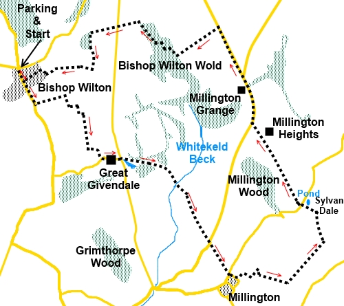
The walk starts at Bishop Wilton. To get
there, turn south off the A166, just to the west of Garrowby Hill. There is
street parking at the crossroads in the village and a bench for booting up.
Start:
Head south out of Bishop Wilton (SE 797553) along the main street through
the village, passing the pub to your right. After about 1/3
mile, turn left off the road following the fingerpost “Public Footpath
Minster Way” (SE 799547). Go through a kissing gate and the footpath goes
straight ahead up the hill, following the left hand field boundary.
%20Centre%20of%20Bishop%20Wilton.jpg)
About 100 yards short of the top of the hill,
the path swings to the right following a terrace in the hillside (SE
804749). There are fantastic views here across the vale of York and several
power stations should be visible.
%20View%20over%20Vale%20of%20York.jpg)
The path drops down off the terrace to a
gateway. Go straight ahead through this, to the top of the field, then, turn
right to follow its boundary. As the fence swings left, follow it round. You
reach a corner with a padlocked gate (at least it was when I did the walk)
and a yellow arrow indicating a right turn for the footpath. It may not be
obvious but you need to climb the wooden fence area next to the gate, then
turn right. The path is clear, sandwiched between the fence and hedge.
Follow this path to a walkers’ gate then
turn left (SE 808540).
You are on a track which divides, the left
hand arm going to a farm but you take the right fork. It is indicated by a
yellow arrow and you are now on the Chalkland way.
At the road, turn left following the Minster
Way finger post (SE 810539), passing through the tiny hamlet of Great
Givendale. When you get to the road junction, have a look at the prettily
situated St Ethelburga’s Church ahead of you, rebuilt in 1849, using parts
from an earlier Norman church.
%20View%20near%20St%20Ethelburgas%20Church.jpg)
%20St%20Ethelburgas%20church.jpg)
%20St%20Ethelburgas%20church%20interior.jpg)
The continuation of our route runs down the
left hand side of the church, following the Minster Way’s obvious
bridleway.
Pass a couple of junctions on the left,
clearly marked as “Private”.
Through a double set of 5 bar gates, climb
the hill following the left hand boundary of the field and head for the gate
which comes into view. Go through this and turn right.
At the road keen straight ahead (SE 827525),
along a quiet lane shown as The Balk on the 1:25,000 scale OS map and at the
cross roads, go straight ahead into Millington village. The route goes off
to the left shortly (SE 831519), indicated by a public footpath fingerpost.
To visit the Ramblers Rest café or the Gait Inn, pass this fingerpost and
turn right at the junction. To visit St Margaret’s church, where there are
useful benches for your sandwiches, turn first right again.
%20St%20Margarets%20Church%20Millington.jpg)
Return to the finger post and follow it along
the tarmac track. The footpath quickly turns off to the right, going down to
a house where the path continues along its right hand side down a wooden
walkway. The walkway evolves into wooden steps into the field. The path goes
straight up the field although there is a broad track to the left across the
field and which bends to the same point, if you wanted to even out the slope
a little.
Bear to the right at the corner of the fence
and follow the obvious track to the hilltop where there is a three-way
fingerpost (SE 840519). Go through the kissing gate and turn left here,
following the fingerpost for the “Yorkshire Wolds Way”, passing Warren
Farm.
%20Millington%20Wood.jpg)
%20Scoar%20Dale.jpg)
Just past the farm, there is a two way
fingerpost. Take the Yorkshire Wolds Way path. Over to the left across
Millington Dale is Millington Wood. The path follows the right hand field
boundary and curves round, left, at the end of the field to descend to the
floor of the valley, via a kissing gate (SE 845530). This is Sylvan Dale, a
typical ‘V’ shaped curving Wolds dale.
%20Sylvan%20Dale.jpg)
On reaching the valley floor, you will be
pleased to know you ignore the steep steps ahead and turn left.
Go through a kissing gate, along the path
between the fence and hedge. Cross a footbridge across the stream, alongside
a pond and go straight ahead at the road.
You now follow the course of an old Roman
road, climbing gently to pass Millington Heights (SE836543). At the road,
turn right. You now have about a mile of road walking. The first half mile
passing Millington Grange can be quite busy with large lorries but there is
a wide grass verge to keep you out of harms way. Just past the Grange, turn
left following the road sign for “Malton 13 miles”.
As you reach some power lines, look for the
left turn indicated by a public footpath fingerpost (Se 828560) and follow
the left hand field boundary down past the plantation. According to the map,
the footpath swings off to the right part way along the valley after the
plantation but the simplest route and what looks like the normally accepted
route is to stick with this boundary until you are nearly at the trees
straight ahead. Look out for a yellow footpath arrow on the left, indicating
you should turn right (SE 822555). Descend the valley from here to the gate
at the bottom which you will soon see.
%20Spur%20Off%20Deep%20Dale.jpg)
Through this gate, climb up through the trees
following the yellow arrow. There are rough log steps to help you up the
hill.
At the top of the steps, turn right on a
broad track and stay on this until you reach the road, curving left past the
sign for Cot Nab. Go straight ahead at the road.
Go through a walkers’ gate and keep
straight ahead as the field descends. At the bottom of the field by the
trees, turn left to follow the line of the trees (SE 808559). As you get
half way along the wood, head for the gate in the field about 50 yards left
of the corner.
Go through the kissing gate and follow the
path as it curves clockwise around the top of the little valley. You pass a
bench provided by the Hull CHA Rambling Club (founded 1911).
%20Bishop%20Wilton%20in%20the%20evening%20sun.jpg)
You more of less follow the contours of the
top of the valley, as it curves round. Follow the left hand fence. Along
here, I must confess to missing a gate (engrossed in conversation –
happens to us all!). I followed the path down to the bottom of the valley
where I turned left through a double walkers’ gate arrangement. After
walking along a couple of hundred yards looking left up the hill, I could
see the gate I should have come through. No matter, Bishop Wilton is clearly
in sight.
At a kissing gate, turn right and left at the
tarmac to return to the centre of the village.
If you need to buy any
hiking equipment/clothing before your trip see the Hiking
Store
All information on this
site is given in good faith and no liability is accepted in respect of any
damage, loss or injury which might result from acting on it.
|


.jpg)
.jpg)
.jpg)