
|
|
|
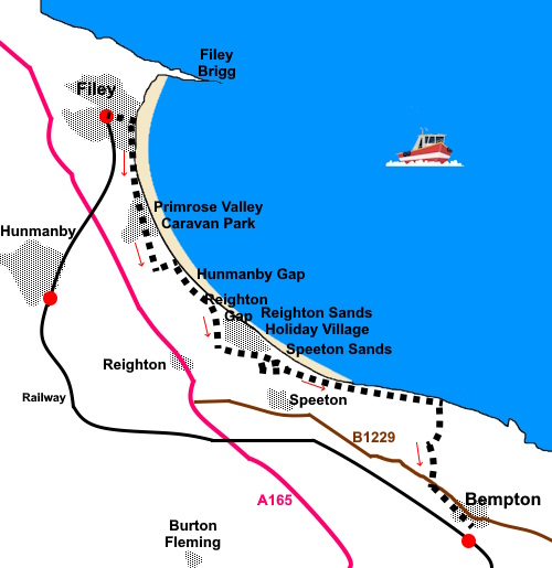
To view route as a dynamic Ordnance Survey map click here. Introduction: This linear route follows the King Charles III English Coast Path from Filey to Bempton, using the train from Bempton Station to the start point at Filey. The path was renamed King Charles III English Coast Path in 2023 to celebrate the coronation of His Majesty. Although I have visited the Filey and Flamborough areas many times over the years, I had never walked this section and in fact much of the path is relatively newly accessible. Walking it reveals the magnificent expanse of Filey Bay and its beautiful sand. Indeed, you could walk a significant section of this walk along the sands, as long as you were sure of the tide times and aware of the exit points – primarily Primrose Valley, Hunmanby Gap or Reighton Gap. Do not try to climb the cliffs. They are boulder clay, prone to collapse and you will probably get into a mess! Primrose Valley and Reighton Gap are somewhat blighted by huge caravan parks. The path goes through the one at Primrose Valley and circles the one at Reighton Gap. Filey was originally a small fishing village but its expanse of beach turned it into a popular holiday resort, no doubt following the introduction of the railways. A tiny amount of fishing continues and the small fishing cobles can be seen stood on Coble Landing (though this walk goes in the opposite direction and you will not see them without a short diversion north along the promenade). At Speeton Sands are curious areas of what look like collapsed cliff named as Black Cliff and Middle Cliff on the map. These seem to have notably different vegetation to what is on the cliff tops. As you near the end of Filey Bay, the huge Buckton and Bempton cliffs, famous for bird watching, come into view. Eventually you pass the trig. point above Buckton Cliffs which was curiously well white painted on the inland side but not the others. Whether this is due to intention or erosion I do not know. The walk pulls back from the cliffs via a curiously named Hoddy Cows Lane, just a dirt track really. It may have got its name via “Odd [single] Cows” that villagers had and they would gather them for milking before putting them out to graze. Another theory is that it was named after “Hooded Crow” which used to be found here. The lane takes you to the hamlet of Buckton by an attractive pond. Really an extension of Bempton, a quick stroll through both will return you to Bempton Station/parked car. The route is easy in terms of ascent/descent and is well waymarked. The walking itself starts from Filey and I got there from Bempton Station via train. There is street parking between the station and the village centre. Bempton is off the B1229, just North West from Flamborough. Start: Directions assume you arrive at Filey station from Bempton Station (or on the train from a southerly direction). Cross over the bridge and exit the station, walking down Station Approach to the roundabout. At the roundabout, bear right along Station Avenue. This becomes Murray Street, then continues down Cargate Hill to the sea front. Descend the steps to the ‘prom’ and turn right along it.
Continue to the end of the ‘prom’ where there is a semi-circular café and climb the ascending path through the trees. After 50 yards or so, turn left up some steps indicated with a fingerpost bearing the long distance walking acorn sign and an 18 hole mini golf course. At the top of the steps, turn left along a gravel path. A two way fingerpost with the acorn sign confirms you are on the right route.
You will soon reach a fork (TA 119799). Ignore the right hand fork and continue along the cliff path. Reach another junction with a three way fingerpost. Go left continuing to follow the acorn sign (TA 120790). Note, you can take the other path at that junction which arguably cuts off a corner but it descends steeply into a little valley then over a footbridge, which means of course, you have to climb out again! Either way, you join a broad track. Turn right up it, keeping a look out for some steps on the left. Climb these and ahead of you there is a fingerpost pointing the way and some helpful white lines showing where to cross the road! This section of the route now passes through the huge Primrose Valley caravan site, where the route is well marked. .After a few yards, reach another junction. Keep left heading towards the sea. Over to the right is the “Owner Services” building. There are caravans at a lower level but stay on the higher terrace, keeping the caravans on it to the right. As you get to the end of the terrace, there is another acorn fingerpost. Follow it left to continue to follow the route. You now enter a section marked with posts as a “permissive path”. Follow these until you get to a tarmac turning circle. Turn right briefly then left, following a permissive path sign. At the end of the row of caravans, there is a two way fingerpost by a bench. Turn right. Do not be mislead (as I was) into turning left by the trampled grass, thinking you will get to a cliff path. The paths disappear into dense shrubbery! The route now follows a somewhat tortuous, though mercifully short route through the houses, starting along Silversands Way. At the ‘T’ junction with Turnberry Drive, turn left. At the ‘T’ junction by the
John Paul Jones pub, turn left along Sunrise Drive and after about seventy
five yards, turn left across a small car park and through a walkers’ gate
(TA 123774). Follow the obvious path to the cliff edge and turn right to follow it.
You reach the car park at Hunmanby Gap. Follow the seaward edge of it and just before the attendant’s hut, turn left down a short path to the beach lane and left along it.
Just before the beach café, follow the lane round to the right of the bungalow. There is a large English Coast Path sign. Where a path turns sharply down to the beach, keep straight ahead following an acorn fingerpost up some steps.
Continue to follow the cliff path and just as you reach the caravan park at Reighton Gap, the path bears right guided by a fingerpost to skirt round it. On reaching the entrance road to the caravan park, continue straight across it to follow the tarmac to Moor Farm where it continues as a stony track. Pass Bramble Hill Glamping site. The path climbs gently. Just before it passes under some power lines, turn left through a walker’s gate (TA 137758). The path follows the edge of the caravan park, passing a golf course, stored caravans and a crazy golf (they may put this away in the winter!). As the path turns a corner, you will see an old WWII pill box; turn left by it to follow the true path. However, as you get towards the end of the caravan park, you will see a number of mown paths off right. You car cut off a bit of a corner if you wish by taking one of these to the end of the group of trees on the right, arriving at TA 146754. However, I describe the full route.
The path splits. Take the left fork, following a yellow arrow on a post. Follow the path as it curves round to follow the trees and circumnavigates a fenced off wooded area. Once round this, the path returns to the cliff edge.
Look out for a walkers’
gate on the left (TA 158751) This leads to a very risky looking section of the cliff top
path between a row of largely redundant concrete posts on the left and a
wire/barb wire fence on the right. It is the correct way, or was when I did
the walk but I suspect it may not be long before there is more collapse and
the path has to be moved. If you felt more comfortable, you could keep to
the right of the fence but you would have to climb over the fence in the
corner. There are the bracing posts and old stile remains which will assist. Follow to the end of the field on
the right where the path appears to then climb a very steep muddy bank (TA
160750). This is potentially risky. The official path actually turns right
here (to the left of the fence), to meet a broad track at a ‘T’
junction. Turn left along it. You reach the trig. point
above Speeton Cliffs at TA 171748.
Arrive at a two way
fingerpost at a broad track (TA 1849 7460). This is marked as Hoody Cows Lane on
the map. Turn right and follow it to Buckton, emerging at the road by a
pond. Turn left along the road.
Continue to follow the road to Bempton. Turn right along the lane by the farm machinery ‘garage’, or the next one by the White Horse Pub to return to a parked car or the station. If you need to buy any hiking equipment/clothing before your trip see the Hiking Store All information on this site is given in good faith and no liability is accepted in respect of any damage, loss or injury which might result from acting on it.
| | |||||||||||||||||

.jpg)
.jpg)
.jpg)
%20View%20noth%20on%20the%20prom%20to%20Filey%20Brigg.jpg)
%20View%20south%20along%20the%20prom.jpg)
%20View%20south%20from%20cliff%20tops%20at%20Filey.jpg)
%20Early%20part%20of%20the%20cliff%20path.jpg)
%20Approaching%20Hunmanby%20Gap.jpg)
%20Buildings%20at%20the%20foreshore%20at%20Hunmanby%20gap.jpg)
%20Approaching%20Reighton%20Gap.jpg)
%20WWII%20Pill%20Box.jpg)
%20Looking%20over%20the%20caravan%20site%20at%20Reighton%20Gap.jpg)
%20Looking%20Over%20Middle%20Cliff%20To%20Speeton%20Sands.jpg)
%20Trig%20Point%20at%20Speeton%20Cliffs.jpg)
%20View%20From%20Speeton%20Cliffs.jpg)
%20Pond%20at%20Buckton.jpg)