
|
|
|
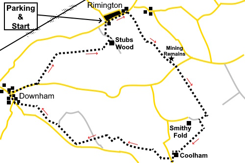
To view route as a dynamic Ordnance Survey map click here. Introduction: This walk takes you on a really attractive countryside circuit in west Lancashire. As it happens, my experience was after wet weather and the ground was extremely muddy and I was glad of my gaiters. The photos do not do it justice as it was a dull, damp overcast day. The walk starts from the pretty village of Remington, skirts under the flanks of Pendle Hill and returns via the lovely village of Downham, from where one of my Pendle Hill walks starts. Named
in the Domesday Book as “Renistone”,
Rimington’s claim to fame was for its lead and at one time silver mining.
Silver mining seemed to peter out but lead mining continued, really until
the late nineteenth century although there were a few attempts to restart in
the early/mid 20th century. You will pass some grassed over
remnants of spoil heaps en route. Downham is an “estate”
village, owned by Lord Clitheroe. The
village is part of
the Forest of Bowland Area
of Outstanding Natural Beauty (AONB). There
is a free public car park in Downham with toilets. Even if you do not need
the services of the toilets, it is worth having a look. Overhead
electricity lines, satellite dishes and aerials are not allowed so the
village is popular for filming period dramas and with tourists.
There is a café and pub in the village. There are also a couple of benches
about half way round the walk which make a useful picnic stop. The walk starts from a lay-by on the edge of
Rimington, although as a circular walk, it could be equally started from
Downham. The easiest way to describe getting to Rimington is to turn south
off the A59 at Gisburn on to the A682. The main signpost is for Nelson but
Rimington also features. After three quarters of a mile. Turn right. The
road runs straight through Rimington. Continue through the village and just
as you are about to leave it, there is a lay-by on the left, opposite
Station Road. There is other parking in the village but if you start here,
the final footpath exits here by an information board. Start: From the lay-by (SD 803457), turn right and walk through the village. Turn right to follow a fingerpost for the Rimington Heritage Way (SD 8074589). Ignore a stile on the left, part way along the field and head for the far left hand corner. There are some ‘lumps and bumps’ in the field which obscure your view of the exit until you are past them, via a walkers’ gate.
In the next field, head towards the right hand corner and through a gateway, then bear left to go through another walkers’ gate and head down towards the farm (Hollins).
Go straight ahead through the farm and up the hill following the yellow arrow on a stile. The lumps on the left as you climb the hill are the remains of Skeleron lead and silver mine.
At the top of the hill, follow the obvious track ahead to the road and turn left. After eighty yards or so, turn right through a walkers’ gate at a public footpath fingerpost (SD 818448). Bear right to a stile and once over it, keep straight ahead crossing the beck via a footbridge, then bear right to the top of the field at SD 819445, where you cross a stile.
Follow the wall on the right hand side. Continue to follow it after crossing a stone stile.
Ignore a stile on the right where there is an unusual carved stone (SD 822440).
At the end of the field, there are a precarious couple of stiles. Straight over the first and immediately right over the next. Keep straight ahead from that stile then turning left along a lane and crossing a stream (SD 822438). After about fifty yards, turn left up a walled track. Follow it as it turns sharply right at the corner of the wall on the right. When the track turns sharply left, keep straight ahead over a stile. The path joins a broader path. Continue ahead, following the wall on the left. There are great views from this path to the north (right hand side).
After going through a farm gate, the path curves gently downhill to a farm (Coolham). Turn left along the wide track.
Follow it down to a lane. Turn briefly right along the lane then quickly left, just after the cottages, on a broad track following a public footpath fingerpost (SD 816430). After a few yards, go through a gap in the wall then bear left, walking parallel with a wall on the left and eventually cross a stile. Through this, follow the wall on the left to another stile and follow the obvious track beyond. As you get to a stone built house, turn left, down to a footbridge SD 812432). Over the bridge, follow the path up to a barn, passing it to the right, then through a walkers’ gate and down to another footbridge. Follow the obvious path uphill until you meet a wall. Turn left to follow it to a gate. Once through this, follow the walled track to a lane. Follow the lane into a field just before the farm and keep to the right of the field. There is a ditch on the right. Follow this. Follow the obvious path crossing a broad stony track down to a farm (SD 801434). Go over a stone step stile and turn right. Follow the path to some trees and cross a stile, turning right to follow the edge of the trees. Go over a gated step stile, keeping straight ahead. There is a post marking the way. You arrive at a barn at SD 798433 where there are two benches. Immediately opposite the barn, go over a stile and follow the right hand field boundary in this and the next field. Go through a kissing gate and over a track through another kissing gate and follow the obvious path, which takes you into the village of Downham.
Walk straight through the village on the main street and turn right just before the pub, to follow the lane for just under half a mile. Look out for a fingerpost on the left, not that easy to spot and turn left through the trees (SD 790445). Immediately, go through a kissing gate and follow the right hand boundary of the field. Go through a walkers’ gate at the end of the field, crossing straight over another footpath. You should see the next stile ahead. The way is obvious and marked with a succession of stiles. Follow the path until you reach a hedge with a gate. Do not go through it but turn left to follow the hedge to the end of the field and go through a slit stile marked with a yellow arrow. Go over a footbridge and turn right (SD 794451). Go through a gateway and turn left to follow the fence, then curving right to follow a yellow marker at the corner of a fence. The path drops down to the stream once more cross the stream and although there is an arrow pointing right, you need to bear left on a public footpath uphill which has no marking on the ground. Reach a gate at the top.
As you gate to the gate, there is a stile and an arrow directing you into the field to the left of the gate. However, I found the way ahead out of this field blocked by barbed wire, despite evidence of the wooden stump of a stile in the corner. Checking the OS map and indeed the Lancashire Definitive Map on my return home, it transpires that the official route is actually into the field to the right of the first stile, then left just before Stubbs Wood (farm?). Major construction work was going on but there was no one around so it was a little confusing. Best advice would be to follow the left hand boundary of the field to the right of the stile, without crossing the stile and turn left along another footpath at the top of the field. If anyone who does this route finds coherent direction indicators have been installed, please let me know, so I can update these instructions. The issue has been reported to the Lancashire Public Rights of Way team. After Stubbs Wood, follow its access drive and as it bends left, turn right to follow the footpath back to the lay-by where you are parked. If you need to buy any hiking equipment/clothing before your trip see the Hiking Store All information on this site is given in good faith and no liability is accepted in respect of any damage, loss or injury which might result from acting on it.
| | |||||||||||||||||

.jpg)
.jpg)
.jpg)
%20Looking%20back%20to%20Rimingron%20from%20near%20the%20start%20of%20the%20walk.jpg)
%20View%20acrsoo%20to%20the%20Ribble%20Valley.jpg)
%20Looking%20over%20Ings%20End%20farm.jpg)
%20Quiarry%20Remains.jpg)
%20Footbridge%20over%20Ings%20Beck.jpg)
%20View%20North%20West.jpg)
%20Unusual%20Carved%20stone.jpg)
%20Pendle%20Hill%20in%20the%20low%20cloud.jpg)
%20Cloud%20just%20clearing%20the%20top%20of%20pendle%20hill.jpg)
%20Coming%20into%20Downham.jpg)
%20Looking%20down%20Downham%20main%20st.jpg)
%20Valley%20with%20Ing%20beck.jpg)