
|
|
|
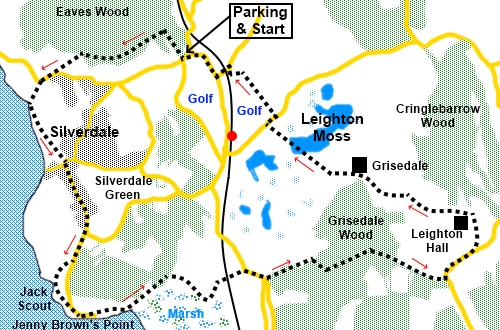
To view route as a dynamic Ordnance Survey map click here. Introduction: This walk in the Arnside and Silverdale AONB takes you round Silverdale, Jenny Brown’s Point and Leighton Moss. It is a varied, easy stroll with a number of interesting aspects. Perhaps the most fascinating of these is an opportunity to watch the fast moving tide of Morecambe Bay. I watched the incoming tide during a picnic on the limestone headland area of Jack Scout and it is quite mesmerising and moves at one heck of a pace. The views from Jack Scout over the bay and to the Lake District are very good. There is a good chance of seeing oyster catchers and curlews too. On the way to Jack Scout, you pass through the rambling, yet strangely alluring village of Silverdale. On the outskirts of Silverdale is Lindeth Tower, built in 1842 as a summerhouse for the Fleetwood family after whom the town of Fleetwood is named. It gained some fame as a writing retreat for the Victorian novelist Elizabeth Gaskell. Past the tower and Jack Scout, you reach Jenny Brown’s Point. Here is a well preserved chimney, believed to be from a short lived copper mining enterprise. There are also remains of Walduck’s Wall, a failed attempt to reclaim land from the sea. Finally the walk crosses Leighton Moss. This has the biggest reed be in the North West and is under the care of the RSPB. From its hides, you could see avocets, otters, bearded tits, marsh harriers, egrets and even red deer plus a whole range of other creatures. The walk starts from a free car park at Eves
Wood on the outskirts of Silverdale. Silverdale and surrounding roads are
quite difficult to navigate. I found the car park by turning off the A6 at
Beetham, then turning along Church Street by the Wheatsheaf pub. Continue to
Slack Head where you fork right for Silverdale. Continue following
Silverdale signs and you should pass the Eaves Wood car park. There are no facilities en route once you leave Silverdale. Start: From the car park, head directly into the wood (Eaves Wood). Follow the main track until you reach a three way fingerpost (SD 470772). Turn left for “The Pepperpot” and “The Cove”. The Pepperpot incidentally requires a diversion to King William’s Hill to visit it. It is a monument erected to celebrate Queen Victoria’s Jubilee and does indeed resemble a pepperpot. The way is signposted. If you visit it, return to this route afterwards. The track starts to follow the edge of the trees, passing a pleasant viewpoint with a stone bench. When the track forks, by a post bearing yellow and white arrows, go left following the yellow arrow. When the track divides again, by a post with more yellow arrows, go right staying on the broader track (SD 465759). Just past some old structures (perhaps part of reservoirs?), the track follows the side of an old, high stone wall. Come to another three way fingerpost and keep straight ahead for “The Cove”.
A few yards further, by a bench, follow the footpath indicated by the fingerpost for “Cove Road”. This runs just to the right of a white painted cottage. Not far beyond this, the path gains the name “Wallings Lane”, indicated by a sign on the wall. The path continues as a broad stony lane. On meeting a tarmac lane, continue straight across it and along a narrow snicket/ginnel/alley (depending on which part of the country you are from), following the fingerpost for “The Cove”. On joining a road, turn right and follow it along. As it bends right, turn left along a no through road (Cove Lane) (SD 458757). Unsurprisingly, this leads you down to “The Cove” on the coast. Turn left to follow the coastal path, following a fingerpost for “The Lots” and “Shore Road”. This takes you along the coast at first, then diverts slightly inland to cross an open green space “The Lots”.
On reaching Shore Road, turn right for only a few yards, then left at the junction following the sign for “Jenny Brown’s Point”. You now walk through the centre of Silverdale. At the junction with Hollins Lane (SD 462742), turn right along the single track road, again heading for Jenny Brown’s Point. Pass the folly Lindeth Tower, with its castellated top, now a holiday cottage.
Continue along this road for just over half a mile. Look out for a walkers’ gate on the right and go through this to follow the footpath to the edge of the coast (avoiding a left fork), an area known as Jack Scout (SD 461740). Turn left at the coast. You could continue along the road to Jenny Brown’s Point but it is worth this diversion either for a picnic spot and/or to watch the amazing tide movement.
Follow the path along the coast. There are various points where you can access the foreshore if you wish but beware the tides. At the end of Jack Scout stretching into the bay is the remains of Walduck's Wall.
Arrive at a kissing gate, by a National Trust sign for “Jack Scout”, rejoin the tarmac lane and turn right.The road runs out at a property with a myriad of privacy signs. The footpath route is to its right along the foreshore. Pass an old chimney. The path then turns inland across a wide grassy area. Keep to the left along by the trees.
Arrive at a four way fingerpost and turn right following the direction for “Quakers Stand” (SD 470738). You follow the top of a raised embankment across marshy land. It curves gently left and you get to a fingerpost. Turn right to follow it through the gate, to a broad track. Pass under the railway, following the fingerpost for “The Coastal Way”.
At the road, turn right along it as far as the bend then turn left following a fingerpost for “Coach Road”. Pass the first farm on the right and just before a second one, turn right up through the trees following a public footpath sign (SD 481739). After a hundred yards or so, the footpath branches off to the left. Do not go through the gate directly ahead. Follow the path through the woods and on joining a broad track, turn left through a slit stile then follow the obvious track to the right. Just before a gate clearly marked private, turn left to follow the yellow footpath arrow (SD 485739). Follow the trees on the left to a gate. Turn right through this to follow the wall on the right. As the wall ends and changes to fence, continue in the same direction straight ahead (i.e. don’t follow the fence) to the opposite corner of the field. As you enter the trees, look out for a difficult to spot post with a yellow arrow and follow its direction. It is about seventy five yards to the right of a gate bearing a white notice. Follow the path as it bears right. Don’t go up the steeper banking ahead. The path leads up to a gated slit stile which you can see from quite a way off. Cross the stile on to a broad track and turn left. Follow it to the road and turn left. Follow the road for just over a quarter of a mile until, just after the second passing place, you reach a fingerpost on the left for “Summerhouse Hill” (SD 500741). Turn left to follow it. Join another footpath and turn left, heading downhill towards the rear of Leighton Hall, the imposing building below.
By the hall, turn right over the cattle grid on to a tarmac lane. Follow this down to some farm buildings, ignoring the paths off to the right for “Yealand Redmayne” and “Yealand Storrs”. Pass Grisedale Farm and in the field beyond, opposite a barn with substantial buttresses, turn right to follow a blue bridleway arrow (SD 487748). You cross Leighton Moss where there are bird hides and the chance to see various water birds, depending on the time of year. Keep an eye out in the reeds also.
At the far side, on reaching the road, turn right for a mere one hundred yards then go left following the public footpath fingerpost for “Redbridge”. Through a kissing gate, enter Silverdale Golf course bearing right to follow the white arrow. A notice tells you to follow the marker posts. Fine instruction but I could not identify which posts. If you are following my GPS route, you will be following the footpath as marked on the OS map, or you could walk a compass bearing of 323°, to arrive at the woods at the far side of the course. There is a step stile (SD 478757). Cross and follow the fingerpost for “Moss Lane”, crossing a broad track and taking the narrow path through the trees. On joining a broad track, turn right to the road, to avoid the pedestrian railway crossing. At the road, turn left over the railway then right. At the next junction, turn left along Park Road, in the direction of Silverdale. The parking is after a few yards on the right. If you need to buy any hiking equipment/clothing before your trip see the Hiking Store All information on this site is given in good faith and no liability is accepted in respect of any damage, loss or injury which might result from acting on it.
| | |||||||||||||||||

.jpg)
.jpg)
.jpg)
%20The%20structures%20mentioned%20in%20the%20text.jpg)
%20The%20Cove.jpg)
%20View%20across%20the%20bay%20to%20grange%20Over%20Sands.jpg)
%20Crosing%20the%20Lots.jpg)
%20Lindeth%20Tower.jpg)
%20View%20from%20Jack%20Scout.jpg)
%20Walducks%20Wall.jpg)
%20Old%20Chimney%20and%20quay%20at%20Jenny%20Brown's%20Point.jpg)
%20Grassy%20area%20after%20rounding%20Jenny%20Brown's%20Point.jpg)
%20Crossing%20the%20marsh.jpg)
%20About%20to%20descend%20to%20Leighton%20Hall.jpg)
%20Part%20of%20Leighton%20Moss.jpg)
%20Part%20of%20Leighton%20Moss.jpg)