|
Lanzarote
Walk - Caldera Blanca
|
Starting
point:

Parking
area just outside Mancha Blanca village
|
Map
I
have found this to be the best map for both walking routes and driving, from
Discovery Walking Guides Ltd
Lanzarote
Tour and Trail Map 1:40,000 scale

| |
Distance:
5.6
miles
| |
Traffic light rating:


(For explanation see My
Walks page)
More great Lanzarote
Walks
|

Click
the PDF logo above to give a printable version of this walk without the
photos.
|
Introduction: This
is the “must do” walk for anyone independently walking on Lanzarote. It
takes you across a dramatic lava field and up the outside of a spectacular
volcanic crater. On reaching the rim, a fine ridge walk is then possible
around its circumference. The views are fantastic in all directions and many
other volcanic creations are visible. It definitely has the “wow”
factor.
Please take sun
precautions on this walk. There is not a square inch of shade. Also take
plenty of water. I took 1½ litres with me, drank the lot and could have
drunk more.
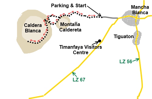
The starting point
for the walk is a car parking area at the end of a good condition dirt road
just ¼ mile west of the village of Mancha Blanca where the LZ 67 turns
south west. Turn west off the bend and follow the dirt road until you can go
no further. There is a parking area and an information board.
Start:
With the information board to your right, walk straight ahead and the marked
out footpath is obvious. You can see your destination Caldera Blanca ahead
with the Montaña Caldereta in front of it.
%20Calderas.jpg)
Continue
along the meandering footpath and eventually it forks. Take the right fork.
If in any doubt, you will by this time be able to see the peculiar rock
formation in the photo below. Head for this. Just near it, you will pass
some stone animal pens (probably for goats).
%20Unusual%20rock%20formation.jpg)
You
are now at the foot of the Caldera Blanca cone and will be able to see the
path gently climbing diagonally up its flank. Turn left and follow the base
of the cone until you reach this path.
On
reaching the top of the crater, after marvelling at the sight, turn left to
follow the rim to the summit marker.
%20Panorama%20as%20crater%20rim%20is%20reached.jpg)
%20Montana%20Teneza.jpg)
%20Panorama%20from%20part%20way%20along%20the%20rim%20out%20towards%20the%20sea.jpg)
%20View%20south%20from%20the%20summit.jpg)
%20View%20along%20ridge%20from%20summit%20marker.jpg)
From
here, I believe it is possible to walk round the crater but there is a
descent and ascent and quite honestly in the heat on the day I did the walk,
I took the softer option and retraced my steps back to the base of the cone.
Here, go right and follow the path across to Montaña Caldereta. This is
less distinct than the outward path but fairly easily discerned.
At
Montaña Caldereta, follow it round clockwise and rejoin your outward path.
Turn right to get back to the car park.
If you need to buy any
hiking equipment/clothing before your trip see the Hiking
Store
All information on this
site is given in good faith and no liability is accepted in respect of any
damage, loss or injury which might result from acting on it.
|


.jpg)
.jpg)
.jpg)