|
Lanzarote
Walk - Rubicon Plain
|
Starting
point:
Faro de Pechiguera (lighthouse), Playa Blanca
|
Map
I
have found this to be the best map for both walking routes and driving, from
Discovery Walking Guides Ltd
Lanzarote
Tour and Trail Map 1:40,000 scale
| |
Distance:
10
miles
| |
Traffic light rating:

(For explanation see My
Walks page)
More great Lanzarote
Walks
|

Click
the PDF logo above to give a printable version of this walk without the
photos.
|
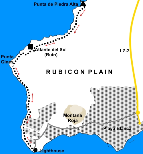
Introduction: The Rubicón
Plain is effectively a desert, in the south west corner of Lanzarote, just
north of Playa Blanca. It is a somewhat eerie area overlooked by the Hacha
Mountain range, the Atalaya de Femes mountain with its forest of
aerials and
Montaña
Roja.
The
walk follows the coastal edge of the Plain where there can be impressive
breakers crashing ashore. Despite the desert nature, there are some
interesting plants here and there.
Somewhat
sadly, the most significant feature on the walk is the ghostly ruin of the
huge Atlante del Sol hotel. Believed to have been built in the 1960s or
1970s, it is difficult to find out much definite information about it. There
are tales of failed attempts to create a golf hotel, embezzlement and
illegal development. Whatever the truth, one wonders at the logic of ever
considering building a hotel in this remote spot in the first place. There
is no beach, although there are Los Charcones – natural seawater pools,
which I did not investigate.
The
hotel was “squatted” at one time by some unsavoury characters but now
seems fully abandoned to its fate. Indeed, it is clearly in a very dangerous
state, with part of it having collapsed and I would not venture too close.
Despite
having perhaps painted a bleak preamble for this walk, it nevertheless seems
quite popular and I saw a few people doing it. Part of the reason for this
is no doubt its proximity to Playa Blanca where in effect you follow its
promenade west to its end and simply keep going past the Faro de Pechiguera
(lighthouse).
It
is an easy walk in that there are no gradients.
If
you have the benefit of access to a couple of vehicles or are prepared to
make use of taxis one way, this could be treated as a linear walk to the
Salinas de Janubio (saltpans). However, I did it as a “there and back”
walk from the lighthouse to Punta de Piedra Alta, where there is a “trig.
point”. You could of course walk less than this by simply turning back
when you have had enough.
I
started from the Faro de Pechiguera, where there is plenty of parking. To
get there by car, turn west off the LZ2 on the northern outskirts of Playa
Blanca at the roundabout with the filling station, following the Faro de
Pechiguera sign. Count the mini roundabouts and at the seventh one, turn
left down to the lighthouse.
As
you are following the coast, directions are really superfluous but I will
give a few.
Start: Facing
the sea, turn right and follow the coast along. After a hundred yards or so,
cross a low (couple of feet) wall where generally, there are some rocks
piled up to make a crude stile. Alternatively, if you follow the fence, you
will avoid the wall altogether.
%20Faro.jpg)
%20Montana%20Roja.jpg)
Pass
to the seaward side of some very smart villas where briefly, the path is a
broad track.
After
passing some open ground, you come to the end of a cul-de-sac road
presumably built for future development. Continue beyond here along the
paved promenade.
Shortly
after the end of the promenade, the broad track curves right. On the bend,
take the path on the left.
Soon,
you pass an iron waymarker with a red arrow pointing along your route. You
will see more of these.
%20Waymarker.jpg)
You
arrive at an “off-grid” habitation where there are a number of caravans
and an old building. Follow the path to the seaward side, passing a small
stone shrine.
Eventually,
arrive at a stone wall At Punta Gines, which no longer seems to serve any
useful purpose. You could be forgiven for thinking the path goes left here
but in fact it goes straight on past the landward end of the wall.
Beyond
the wall the path becomes rather indistinct as you cross a stony area but
the Atlante del Sol ruin is clearly visible ahead. Just make your way
towards it the best way you can.
%20Atlante%20Del%20Sol.jpg)
%20In%20Memorium.jpg)
Pass
the ruin – I opted for the landward side to keep away from the collapsing
area. The broad track you should be on by now turns inland for a while.
Follow the track along passing a stone shelter which could provide a lunch
stop, although it seemed to have been used for fly-tipping as I passed.
%20View%20north%20to%20Punta.jpg)
%20Atlantic%20breakers.jpg)
Simply
follow the coast along until the trig. point at Punta de Piedra Alta comes
into view.
%20Punta%20de%20Piedra%20Alta.jpg)
The
return journey is a matter of retracing your steps.
%20Struggling%20to%20survive.jpg)
If you need to buy any
hiking equipment/clothing before your trip see the Hiking
Store
All information on this
site is given in good faith and no liability is accepted in respect of any
damage, loss or injury which might result from acting on it.
|


.jpg)
.jpg)
.jpg)