|
Appleton-le-Moors
Circular Walk to Hutton-le-Hole and Lastingham
|
Starting
point and OS Grid reference:

Appleton-le-Moors
– On street free car parking (SE
735879)
|
Ordnance
Survey Maps
OL26 N Y Moors - Western area & OL27 N Y Moors Eastern area.
Buy these maps from
List
of OS Maps
Commission from map sales is
used to fund the website, so keeping it free to use.
| |
Distance: 9 Miles
| |
Traffic light rating:

(For explanation see My
Walks page)
| |


For advice on .gpx files see
My
Walks page
|

Click
the PDF logo above to give a printable version of this walk without the
photos.
|
To
view route as a dynamic Ordnance Survey map click here.
Introduction:
This North York Moors walk from
Appleton-le-Moors follows a circular route taking in the picturesque
villages of Hutton-le-Hole and Lastingham. Appleton-le-Moors escapes the
tourism which sometimes overwhelms Hutton-le-Hole and as a result is a
peaceful and tranquil place, unchanged for centuries and which is recorded
in the Doomsday Book. The Moors Inn awaits you there, at the end of your
walk! Its unassuming exterior belies the cosy atmosphere inside.
There are teashops and pubs
in Hutton-le-Hole and Lastingham for sustenance en-route or the bench on the
village green in Lastingham makes a good picnic spot. There are public
toilets on the car park at Hutton-le-Hole.
Very interesting visits
along the way are the Ryedale Folk Museum in Hutton-le-Hole and the
spectacular St. Mary’s Church in Lastingham.
This church could fill a
website by itself! Suffice to say it has a reputation for “Earth
Mysteries”, being supposedly on a “Ley” Line and with its unusual
crypt haunted by good and evil
spirits. My cosy blanket of cynicism seemed to protect me! It does however
have very ancient parts, being founded by St Cedd in 654AD. The crypt dates
from 1078 AD and is built over his grave. St. Cedd’s well in the village
is one of several holy wells hereabouts and probably the best preserved. You
will pass it on the walk.
Rather annoyingly, if you
do not have one (or both) already, this walk spans two maps. Having both
will stand you in good stead for many other walks but if I had to choose
only one for economy, for this walk, I would pick OL 26 as the walls/tracks
used in the directions for the latter part of the walk are pretty obvious.
There is some road walking,
notably about a mile into Lastingham but the roads are quiet.
The walk starts in
Appleton-le-Moors which has a wide street with plenty of room for parking.
To get there, turn north off the A170, about half way between Kirkbymoorside
and Pickering (signposted).
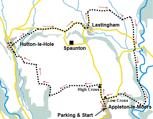
Start:
From Appleton-le-Moors (SE 735879), walk north on the main street passing
the Moors Inn on the left and Christ’s Church on the right. As you leave
the village, note the stump remains of medieval Low Cross on the right at
the road junction signposted to Cropton. Your return journey brings you back
to this junction. Keep straight ahead now.
%20Appleton-le-Moors%20Main%20St.jpg)
%20Appleton-le-Moors%20Church.jpg)
%20Low%20Cross.jpg)
%20High%20Cross.jpg)
Further along the road, you
come to the remains of High Cross on the left and shortly after this, turn
left over a stile indicated by an old metal public footpath post (SE
733886). Follow the left hand boundary of the field until you get near its
end then work your way right to the gap in the hedge about 2/3
of the way along the far boundary where there is another stile. Cross this
and follow the right hand boundary of the next 2 fields.
On reaching a broad track,
turn left then immediately right following the public bridleway sign. This
lane leads to a gate where you keep straight ahead following a blue
bridleway arrow.
Almost at the end of the
next field, turn right through a 5 bar gate (SE 717883), again following the
blue bridleway arrow, through the trees. The track follows the edge of the
woodland eventually bending left. Ignore a right turn and at a three-way
fingerpost, keep straight ahead on the bridleway.
On meeting a broad stony
track, turn right (SE 714887). Continue following the blue bridleway arrows,
ignoring a track off to the left.
The track becomes hedged on
both sides and when the left hand hedge goes left, follow the track round
with it.
Stay on the track as it
bends right, ignoring a track to the left. It now starts to descend. It
emerges on to a tarmac lane. Turn right to follow the direction for
Gillamoor. Turn right at the main road.
You come into the pretty
village of Hutton-le-Hole, with the stream running down its centre. It can
get quite busy with traffic through the village so to avoid this and to get
the best views of the stream, follow the road to the left of the stream,
before turning right across the little footbridge.
%20Hutton-le-Hole.jpg)
Note the Ryedale Folk
Museum, to the left which is well worth a visit if you
have time.
After
crossing the footbridge, turn right on the road and walk down past the
little church on the left. Opposite the village hall, turn left on to the
public footpath indicated by a fingerpost (SE 706899).
%20St%20Chads%20Church%20Hutton%20le%20Hole.jpg)
Follow the
left hand field boundary before crossing a footbridge into the woods. The
route is obvious and on reaching the road, turn right (SE 714904). Follow
the road for half a mile to a road junction and turn left for Lastingham –
about another half a mile.
As you
arrive in Lastingham, the church is on the right and a “must see”. Turn
right just past it. The entrance to the church grounds is on the right after
100 yards or so – it turns back at a sharp angle.
%20St%20Marys%20Church%20Lastingham.jpg)
%20St%20Marys%20Church%20interior.jpg)
%20The%20Crypt.JPG)
After
visiting the church, return to the corner and follow the road sign for
Cropton. You pass to the right of the small village green where there is a
handy bench for a picnic.
Further
along this road you pass St Cedd’s Well on the left, just after the
bridge. There are other wells in the village if you want to hunt them out
but this is the best preserved and most obvious.
%20St%20Cedds%20Well.jpg)
You could now follow the
road to the point marked #
below but it would be a shame not to visit the moor proper,
especially if the heather is out. This only adds about three quarters of a
mile overall. So, take the next (no through road) on the left indicated for
Lastingham Grange Hotel (SE 729904). This is High Street. At the end of the
road, you enter the moor and follow the track which bends right to follow
the wall. Only the first section is shown as a public footpath on the map
and thereafter it is shown as a dotted track but it is plain enough on the
ground.
%20Moorland%20Near%20Lasrtingham.jpg)
%20Moorland%20Valley%20Near%20Lastingham.jpg)
Stay on this route
following the wall/fences for three quarters of a mile at which point it
drops down to a stream (SE 740907). There are a few rocks to help you
across. The path then rises and you need to head for the left hand corner of
a walled wood above you. Ignore the stile on the right.
Follow this wall round and
at another corner (SE 743908) head down to the cattle grid (slightly left).
Cross the cattle grid and follow the lane down to the road, then turn left.
At the next road junction
on the bend (#), turn right for Appleton-le-Moor.
Cross the bridge then go
left over a wooden stile (SE 744897). Follow the left hand boundary of the
next two fields until you enter the trees via a walkers’ gate.
Follow the obvious path to
Appleton Mill Farm then turn right along the farm drive (SE 746880).
At
the road turn left by Low Cross and you are soon back at Appleton-le-Moors.
If you need to buy any
hiking equipment/clothing before your trip see the Hiking
Store
All information on this
site is given in good faith and no liability is accepted in respect of any
damage, loss or injury which might result from acting on it.
|


.jpg)
.jpg)
.jpg)