|
Coxwold
Walk
|
Starting
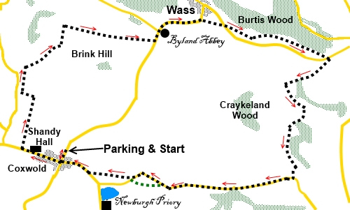
point and OS Grid reference:

Coxwold
– Car park to the rear of the village hall (SE 536773)
|
Ordnance
Survey Map
OS
Explorer 299 - Ripon and Boroughbridge.
Buy this map from
List
of OS Maps
Note: If you use OS Maps on-line, you can download this route via this
link.
| |
Distance: 7.9 miles
| |
Traffic light rating:

(For explanation see My
Walks page)
| |


For advice on .gpx files see
My
Walks page
|

Click
the PDF logo above to give a printable version of this walk without the
photos.
|
To
view route as a dynamic Ordnance Survey map click here.
Introduction:
This walk from
Coxwold, a very attractive village nestling just inside the North York
Moors National Park boundary, takes you to the magnificent Byland Abbey,
before leaving the Park itself to circle back to the start. This is an easy
walk across gently rolling countryside, just below the escarpment of the
Park. There are good views of the escarpment itself, including the White
Horse hill figure at Kilburn.
Coxwold has won several “best kept”
village awards. At the top of the main street stands St Michael’s Church,
with an unusual octagonal tower and an equally unusual horseshoe shaped
communion rail. Further along is Shandy Hall. Laurence Sterne, the 18th
century author lived here and wrote the famous Life and Opinions of Tristram
Shandy, naming the house after the character. The hall and gardens are open
to the public at times – check website for details.
Byland Abbey is both an impressive 12th
Century ruined abbey in the care of English Heritage and the name of the
small hamlet. The lower half of a rose window circle of astonishing size
remains.
Refreshments can be obtained at the Abbey Inn
(now just a café/B&B), at Byland Abbey, the Wombwell Arms at Wass or at
the 17th Century Fauconberg
Arms in Coxwold after the walk.
The
walk starts from a free public car park at the rear of the village hall on
the road north out of Coxwold. Coxwold lies to the east of the A19, between
Thirsk and Easingwold. The road to it from the A19 forms part of the caravan
route to avoid Sutton Bank and is well signposted. Other cross country lanes
to the village can be quite confusing! Assuming arriving from the A19, turn
left at the village centre cross-roads following the road sign for Byland,
Wass, Ampleforth and Helmsley. The car park/village hall are a mere 250
yards further on the right.
Note:
Apologies for the relatively poor photos but it was a very hazy day.
Start:
From the car park (SE 536773), turn left along the road back to the cross-roads and
turn right. Walk through the village, passing the church and Shandy Hall. At
the National speed limit sign, turn right on a public footpath following the
“Village Hall” fingerpost and yellow public footpath arrow (SE 530773).
Unless recently walked, the footpath route has little to indicate it across
the field. Keep straight ahead from the gate and once over the higher part
of the field, you should see another fingerpost in the corner.
%20View%20up%20Coxwold%20Main%20Street.jpg)
%20St%20Michaels%20church.jpg)
%20Shandy%20Hall.jpg)
Cross the stile next to the fingerpost and go
straight ahead. At the end of this next field, go through a gap in the hedge
in the corner and across the middle of the next field.
Once across it, turn left following the
fingerpost for “Cams Head”. At the next three way fingerpost, turn right
for Cams Head, following the left hand boundary of the field and in the
corner, cross the stile and bridge, again following the left hand field
boundary.
%20View%20towards%20NY%20Moors%20escarpment.jpg)
There is another stile/bridge arrangement at
the other end of the field. Cross and turn right, to follow the right hand
field boundary (SE 530784).
%20View%20towards%20Kilburn%20White%20Horse.jpg)
Go through the gate in the corner and follow
the clear path through the trees to a field where you follow the right hand
boundary to the corner where you turn right at a three way fingerpost for
“Byland Abbey” and follow the left hand field boundary to a stile, cross
it and turn right.
Follow the right hand boundary of the next
two fields and Byland Abbey comes into view. The route to the road is clear
and at the road turn left to Byland Abbey (SE
548788).
%20Byland%20Abbey.jpg)
Pass the abbey, staying on the road for about
half a mile, curving to the right, around it. As the road bends sharply to
the left, branch off right, following the public footpath sign. Pass to the
left of the Wass water treatment works.
This section of the route cuts off the corner
where the attractive Wass village sits. An option is to stay on the road
through the village, perhaps calling at the pub! If you do, follow the road
for a quarter of a mile after turning right at the cross-roads and pick up
the directions at the next paragraph.
After the water treatment works, follow the
path to the road and turn right. Just as it bends left, go over a stile on
the left (SE 559789).
Walk up the field 50 yards or so passing the
scant remains of an old barn. There is a line of rocky outcrops along the
field and you need to keep just to their right.
The path more or less follows the contours of
the land to a footbridge over Burtis Beck (SE 566789). Cross this and bear
slightly left to a stile halfway along the field. Cross this and continue
slightly uphill, crossing the access track to the farm.
%20Rolling%20Countryside.jpg)
After a short rise, the path levels out. Its
route is fairly clear. Pass under some power lines and at the next hedge,
turn right to the stile at the bottom of the field. Cross and turn left
along the road for a couple of hundred yards, leaving it on the right to
follow a fingerpost for “Byland and Colley Broach Road” (SE 573586).
%20More%20Rolling%20Countryside.jpg)
The path descends gently to the right to a
footbridge over a stream (Holbeck). Cross it and bear slightly right. There
is a stone barn on the near horizon and you should see the next stile to its
left.
Cross the stile and bear left to climb the
small hill. Follow the left hand boundary of the field and go through a gate
on the left. Follow the edge of the trees (don’t be misled by the track in
the valley bottom). Cross the stile just to the right of the corner of the
field and through a kissing gate. Go straight ahead across the middle of the
next field.
Once across, turn right to follow its left
hand boundary.
At the end of the field, turn right to follow
a broad track past a farm and at the ‘T’ junction of “tracks”, turn
right. I say “tracks” because that is what they look like but the one on
to which you have turned is shown as a road on the OS map (Colley Broach
Road in fact) (SE 568769).
Stay on the road passing Foxfoot Hay Farm.
About half a mile after this, (SE
550768), a footpath branches off left cutting off a corner of the road.
However when I did the walk, the field was full of thriving crops. Although
one is perfectly entitled to follow the route across the field, I didn’t
have the heart to trample the crops for the small saving of distance
involved and remained on the road.
After passing a sharp left hand bend in the
road, turn off right across a field at a public footpath fingerpost (SE
545769) (or more or less straight on if you have crossed the previous
field).
This next field is a little tricky as there
is an extensive boggy area in the centre, obvious from the bog grass. Best
advice is to keep to its left heading for a small copse of trees. From
there, you will see a kissing gate on to the road. Turn right back to
Coxwold.
If you need to buy any
hiking equipment/clothing before your trip see the Hiking
Store
All information on this
site is given in good faith and no liability is accepted in respect of any
damage, loss or injury which might result from acting on it.
|


.jpg)
.jpg)
.jpg)