
|
|
|
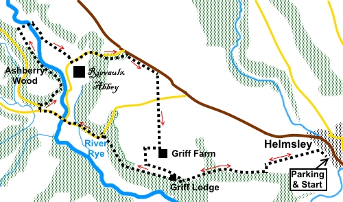
To view route as a dynamic Ordnance Survey map click here. Introduction: This easy walk from Helmsley starts off using the Cleveland Way long distance footpath, giving good views back to Helmsley Castle and to Duncombe Park and over Ryedale. It crosses the ancient Rievaulx Bridge before climbing round Ashberry Hill, from where there are tantalising views through the trees of Rievaulx Abbey. The approach to the abbey along the river provides spectacular views of it. Rievaulx Abbey was one of England's most powerful Cistercian monasteries, founded in 1132. At its peak, there was a community of 650 there. It fell victim to Henry VIII’s suppression of monasteries but a remarkable amount of masonry remains, which gives a clear idea of how important a place this was. It is now under the care of English Heritage. It is open to the public and could be visited as part of this walk. Helmsley is an attractive market town on the A170 Thirsk to Scarborough road. It has a ruined castle and a famous walled garden. There are various places to park in Helmsley but it can get congested and most will probably use the pay and display car park on Cleveland Way (off Church Street) which is where this walk begins. There are toilets. Start: Exit the car park via the “no exit” road then turn left to follow the Cleveland Way, indicated by the fingerpost for Rievaulx 2½ miles (SE 610838). The path starts with a broad track before crossing various fields then, after a walkers’ gate, turning sharply left towards some trees (SE 603836). At the trees, the path turns right to run along the right hand edge of the woods.
The path briefly diverts through the woods, before coming into the open and within a hundred yards, join a broad track and turn right. Almost immediately, the path forks by Griff Lodge. Take the left fork (SE 590834).
Re-enter the woods, meeting a broad track. Continue straight ahead following the yellow arrow.
On reaching the road, turn left (SE 580841). There is a footpath on top of the banking to avoid the (limited) traffic. Continue along the road for just over half a mile, passing and ignoring the right turn to Rievaulx but continuing in the direction of Scorton and Old Byland and crossing Rievaulx Bridge.
At the next road junction, turn right following the road signs for “Cold Kirkby 4 and Old Byland 2 [miles]” (SE 571844). Almost immediately, turn right along the back of Ashberry Farm. There is an old style public footpath sign against the old barn building. Immediately opposite the farm building, go left through a gate climbing a broad footpath indicated by a yellow arrow. Join another footpath and turn right, initially following the edge of the trees.
The path then climbs into the trees through which you get glimpses of Rievaulx Abbey. When the track splits, go right heading downhill following the yellow arrow. After going through a five-bar gate, turn right along a broad track ignoring a footpath off to the left to Hawnby. Cross the river via a bridge (SE 569856) which you see from some way off and continue along the main track as it curves to the right. After about two hundred yards, turn right on to a footpath marked with a fingerpost for “Rievaulx” and the “Inn Way” (SE 571855). Follow the path as it wends its way down to the river and through a walkers’ gate, bear left, indicated by a yellow arrow. Nice views of the Abbey start to open up ahead.
On reaching the road turn left unless you want to visit the abbey in which case, turn right for about two hundred and fifty yards to the entrance. Retrace your steps top this point afterwards. Pass a pretty thatched cottage and St Mary The Virgin church. Just over a hundred yards after the church, take the permissive path on the right signposted to Rievaulx Terraces, indicated by a white arrow (SE 580851). This avoids walking on the road.
Emerge from the trees by the National Trust office and follow its drive. At the road, turn right briefly along the right hand verge of the road. Within a hundred yards, turn right into a drive then immediately left to follow the way-marked footpath “Helmsley to Rievaulx” (SE 584852). This is a permissive path which at the time of writing is not shown on the Ordnance Survey map. The path is parallel to the road initially but at a copse of trees, turns sharp right (SE 587849).
At a road, continue straight ahead following the white arrow. Just before a gate leading into Griff Farm, turn right following another white arrow, to follow the left hand field boundary (SE 588539). Go through two gates and turn sharp left after the second (SE 586839), again following a white arrow. At the next gateway, turn left. Follow the left hand boundary, going left through a gateway. On joining a broad track, turn right. Emerge by Griff Lodge, which you passed on the outward journey. Turn left to retrace your steps to Helmsley. If you need to buy any hiking equipment/clothing before your trip see the Hiking Store All information on this site is given in good faith and no liability is accepted in respect of any damage, loss or injury which might result from acting on it.
| | |||||||||||||||||

.jpg)
.jpg)
.jpg)
%20Helmsley%20Castle.jpg)
%20Griff%20Lodge.jpg)
%20View%20over%20Ryedale.jpg)
%20Autumn%20in%20Ryedale.jpg)
%20First%20sight%20of%20Rievaulx%20Abbey.jpg)
%20Peaceful%20Ryedale.jpg)
%20Approaching%20Rievaulx%20Abbey.jpg)
%20Thatched%20Cottage%20at%20Rievaulx.jpg)
%20Up%20Close%20at%20Rievaulx.jpg)
%20Big%20skies%20over%20NY%20Moors.jpg)
%20Duncombe%20park.jpg)