
|
|
|
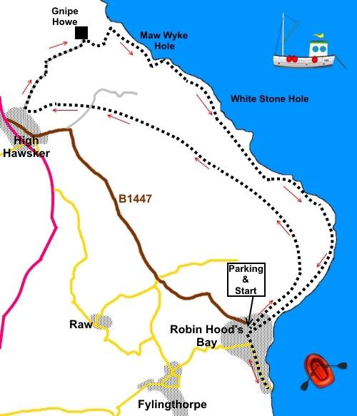
To view route as a dynamic Ordnance Survey map click here. Introduction: Robin Hoods Bay is the picturesque, quintessential fishing /smugglers’ village on the East Yorkshire coast. It is a maze of narrow passages and steep streets. It has both a rocky foreshore and a sandy beach. Although it is not necessary to go through the village as part of the walk route, it would be a real shame not to spend some time exploring it. It is some time since I previously visited Robin Hood’s Bay and I was pleased to see that it looked considerably smarter and better kept this time, though with far too many holiday cottages. Few people actually live there. Robin Hood’s Bay has been in existence since at least 1536. At one time, it was more important than Whitby. Certainly in the 18th century, it was a smugglers haven with fishermen, farmers, the clergy and gentry all trying to outwit the Excise Men. The village was once on the Scarborough to Whitby railway line but this closed in the 1960s. Its route to High Hawsker is now the “Cinder Track” which this walk follows in part. High Hawsker is an attractive village which also once had a railway station. There is evidence of Romans in the area. Its church is All Saints Church, which dates from the 1870s. The walk route is extremely easy to follow and provides for long distance views along the coast as far as Whitby and, on a clear day, as far as the white chalk cliffs at Flamborough Head. As the walk is circular, you could start the walk ay High Hawsker where there is free roadside parking. There are plenty of pubs/cafes in Robin Hood’s Bay for lunch if you wish. However, I started at Robin Hood’s Bay. There is a potential lunch stop at the Hare and Hounds at High Hawsker, which I can thoroughly recommend. The
easiest way to get to Robin Hoods bay, is to turn off the A171 south of
Whitby, at High Hawsker, on to the B1447. Follow the Robin Hood’s Bay
signs. The car park is opposite the Grosvenor Hotel. There is a smaller pay
and display car park which quickly fills but please note there is absolutely
no space for any parking whatsoever in the lower part of the village. Start: From the car park (NZ 950055), turn right to descend into Robin Hood’s Bay.
Return to the car park to start the walk, which is to the left as you exit the car park. Turn on to Mount Pleasant North following the fingerpost for “Cinder Track” and “Cleveland Way”. Follow the road to its end and turning left as it becomes a rougher track, again following the Cinder Track fingerpost. The walkers’ gate to the right is your return route along the cliffs.
The track curves left at first but then curves right. The Cinder Track is obvious, as its name suggests! There is a small sign indicating “Cinder Track to Whitby”, confirming the way. The Cinder Track crosses a tarmac lane at NZ 934078. Go straight across. You start to get views which include the church at High Hawsker and Whitby with its famous abbey beyond.
Simpy continue along the Cinder Track until you get to the first bridge over it at High Hawsker (NZ 928078). Turn right immediately before the bridge, to climb some steps to join a broad track. Turn right to continue the route or, if you want to sample the delights of the Hare and Hounds pub, turn left. The pub is at the end of the lane, past the farm, less than 200 yards. From the bridge, just follow the broad track. At Gnipe Howe Farm (NZ 934085), cross the cattle grid. Ignore the route left indicated by a blue bridleway arrow and go right through a gateway, following the route indicated by the yellow arrow. You should see a fingerpost part way up the field. Head for this. At the fingerpost, by the wall corner, turn left following the “Cliff Path” finger. Follow the path down by the wall until you reach the obvious cliff path, after going over a stile. Turn right for Robin Hood’s Bay. The cliff path is also part of the Cleveland Way.
You pass a number of National Trust signs for Bottom House Farm and Bay Ness.
At NZ 959064 pass beneath a white former coastguard station.
There is a bench with a good view at NZ 959061. At NZ 957059 there is another NT sign, for Rocket Post Field. There is a post in this field with steps up it and a curious metal construction at the top. This is a replica of an actual post, at one time used by coastguards to practising rescue drills using breeches buoys, to extract people from shipwrecks. A breeches buoy was a circular cork float with a pair of stout canvas shorts hanging underneath. An information board explains in full.
As you come into Robin Hood’s Bay, note the fingerpost for “Cinder Track” which is where you started. If you need to buy any hiking equipment/clothing before your trip see the Hiking Store All information on this site is given in good faith and no liability is accepted in respect of any damage, loss or injury which might result from acting on it.
| | |||||||||||||||

.jpg)
.jpg)
.jpg)
%20New%20Road%20Robin%20Hoods%20Bay.jpg)
%20Side%20Street%20Robin%20Hoods%20Bay.jpg)
%20King%20Street,%20Robin%20Hoods%20Bay.jpg)
%20Old%20Steps%20Robin%20Hoods%20Bay.jpg)
%20View%20down%20King%20Street.jpg)
%20The%20cinder%20track.jpg)
%20View%20to%20Whitby.jpg)
%20Telephoto%20Shot%20of%20Whitby%20Abbey.jpg)
%20Coast%20on%20joining%20coast%20path.jpg)
%20Another%20section%20of%20coast.jpg)
%20Old%20coastguard%20station.jpg)
%20Rocket%20post.jpg)
%20Approaching%20Robin%20Hood's%20Bay.jpg)
%20Robin%20Hoods%20Bay.jpg)