
|
|
|
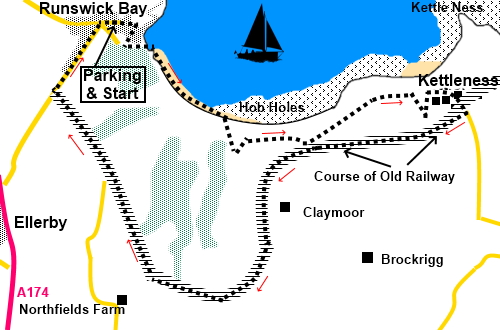
To view route as a dynamic Ordnance Survey map click here. Introduction: This short walk takes you from the pretty village of Runswick Bay to Kettleness, more of a hamlet. Indeed, you could start the walk from Kettleness where there is free parking (you have to pay at Runswick Bay) and you may get the chance of refreshment half way at the Royal Hotel in Runswick Bay but there are a couple of good reasons to follow my route. Firstly, the walk starts along the top of the beach, so you need to be aware of the tides. This is no coast on which to get cut off as the cliffs are very crumbly and dangerous/impossible to climb. Secondly, the access to the old railway route from the Runswick Bay end is very easy to miss. I came across two walkers who had gone a considerable distance out of their way due to missing this. This is one of the easiest walks to navigate (at least in the direction I recommend). There are a considerable number of steps to climb from the beach, hence the amber “traffic light” but there is a welcome bench at the top with a great view. Runswick Bay is in possibly the most attractive setting of any village on Yorkshire's east coast, although you might get arguments from Robin Hood’s Bay or Staithes! The walk down through the narrow paths is a delight, especially as they are impenetrable to cars. The village was originally a bit further north along the coast but there was a landslip in 1682 and it disappeared into the sea! The now mostly, very desirable, holiday cottages were once homes to herring fishermen, with over 20 boats based there. There are few permanent residents today. It is well worth spending a little time wandering about. The beach is renowned for fossils but please do not dig into the cliffs as you could well bring them down on top of you! The village had its own lifeboat from 1866 but it moved to Staithes in 1978. It still has a volunteer rescue boat. Kettleness is a small hamlet but was once larger. It gets its name from the nearby headland Kettle Ness, where, until 1861 this was an important alum works and ironstone mining area. Alum was used in dyeing. Unfortunately, the extensive quarrying/mining undermined the ground with the result that a landslip sent the village into the sea in 1829, fortunately without loss of life. A ghostly black dog known as the Barghest is supposed to haunt the area. I did see a couple with a black dog – no couldn’t have been! I suspect those who claim to have seen the creature have possibly been a “bar guest” for longer than is good for them! The walk starts from the pay and display car park opposite the Cliffemount Hotel. To get there, turn east off the A174 at either Ellerby or Hinderwell and follow the signs. When you get to the fork, with a road sign pointing downhill to Runswick Bay Beach, ignore this and keep straight ahead. The car park is on the right. Although there are other car parks down the hill, using this upper car park gives you the chance to wander through the village and is less busy. Start: Exit the car park and turn right. Walk to the end of the road and follow the narrow footpath down to make your way through the cottages and down to the sea front. The precise route does not matter. Then, walk down the slipway and on to the beach.
Walk along the head of the beach. Ignore an inviting set of steps on the right which are a dead end.
Continue, passing a small group of wooden holiday cottages until you reach the ‘V’ shaped cleft in the cliffs, indicated on the photo (NZ 815155). Turn right here up the right hand side of the ravine to cross the stream via a stepped bridge. Join the long set of steps up to the cliff top.
There is a bench at the top (which you may be grateful for!) from which is a good view of the village.
Continue along the cliff tops until you get to the group of houses which is Kettleness. The path cuts inland slightly to avoid a cleft in the cliffs (NZ 828156) then curves round the left hand side of a large stone barn. Continue along the cliffs briefly. The path does not run through the farm
Join the road out of the hamlet, following the fingerpost for Goldsborough. Pass the old station on the right and about fifty yards further on, turn right on to a broad track where there is a sign for the “Mulgrave Estate” (NZ 832155). You are now on the old railway tack.
After about two and a half miles, pass a brick built house “Ellerby Crossing”, Cross straight over the track here to stay on the old railway route. It is narrower and a little less obvious as an old railway track than the previous section. In just under half a mile, arrive at the road (NZ 804157). Turn right and right again at the ‘T’ junction to return to the car park. If you need to buy any hiking equipment/clothing before your trip see the Hiking Store All information on this site is given in good faith and no liability is accepted in respect of any damage, loss or injury which might result from acting on it.
| | |||||||||||||||||

.jpg)
.jpg)
.jpg)
%20Beach%20at%20Runswick%20Bay.jpg)
%20Runswick%20Bay%20from%20the%20beach.jpg)
%20Looking%20back%20at%20Runswick%20Bay%20village.jpg)
%20Runswick%20Bay%20from%20part%20way%20up%20the%20footpath%20ravine.jpg)
%20Runswich%20Bay%20from%20the%20cliff%20top.jpg)
%20View%20East%20along%20the%20coast.jpg)
%20Approaching%20Kettleness.jpg)
%20Former%20station%20building%20at%20Kettleness.jpg)
%20Elaborate%20Bench%20on%20old%20railway%20line.jpg)
%20The%20old%20railway%20route.jpg)