
|
|
|
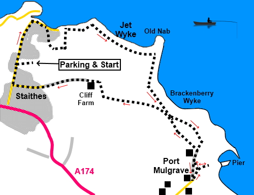
To view route as a dynamic Ordnance Survey map click here. Introduction: This very short walk but it allows for plenty of time to explore the lovely, characterful village of Staithes, where it starts. In my mind, Staithes competes with Runswick Bay and Robin Hood’s Bay for which is the most picturesque. The view of Staithes from the cliff tops is probably the best you will get and there are also attractive views along the coast. The cliff path is easy walking. Staithes was one of the biggest fishing ports in these parts. It is now much diminished in this respect but is still renowned for the “cobbles” – flat bottomed boats which moor in the estuary of Roxby Beck, which flows into the harbour and which are the subject of many a photo. The harbour is in a dramatic setting, beneath a high projection of cliff. There are a number of narrow streets, very pleasant to wander through and virtually no traffic. Most are too narrow. Fish caught here are primarily cod, mackerel and shellfish, crab and lobster. The lobster heritage is celebrated by a huge sculpture near the car park. In the nineteenth century, the village became a centre for artists and that tradition lives on. Staithes has a number of shops, cafes and pubs which cater for visitors but a large proportion of the houses are now holiday lets. Port Mulgrave was an important part of the ironstone industry, from 1855. Ore was initially mined at Rosedale Wyke, in the bay and shipped from the pier to blast furnaces on the river Tees and to Jarrow. When this mine was exhausted, another mine near Dalehouse, just over a mile away, was opened and a narrow gauge railway linked it to Port Mulgrave. Due to various changes in routing of the ore and commodity prices, the port became redundant by 1920 and has gradually decayed since. The pier is now in a very bad state and much worse than when I last saw it in 2009. Fossils can be found on the foreshore, particularly ammonites. On a rocky platform to the rear of the pier remains are a collection of small boats and fishermen’s shacks. All visitors to Staithes have to park in the car park at the top of the hill. There is a council car park but also a private one. This has a number plate recognition system which only allows you 10 minutes to pay. Ensure you have plenty of change as it will take you more than 10 minutes to find change and there could well be a queue at the machine. Failure to enter your correct registration number or pay within the allotted time results in punitive fines! Don’t bother trying to park at Port Mulgrave! To get to Staithes, turn off the A174 about ten miles north of Whitby, following the signs. Start: Walk down the hill from the car park (NZ 782185) into the village. Walk round the right hand side of the harbour, passing the Cod and Lobster pub. Take the next on the right, following the fingerpost for “Port Mulgrave” (NZ 783189).
The steep street eventually becomes a stepped footpath. Keep climbing until you come to a split in the path. Fork left, following the sign for Port Mulgrave.
As the path levels out, pass a large barn then turn left to follow the Cleveland Way footpath.
Follow the Cleveland Way along the cliff tops, until you come to some houses which is Port Mulgrave.
Join the road and follow it, ignoring a footpath off to the left, which will be your return route. As the road bends right, on the left is the National Trust sign for Port Mulgrave. On the left is an information board and through a walkers’ gate is a path down some rough steps to a small bench (“Norm’s Bench”) with a good view of the “harbour” area. To access the water’s edge and the boats, cabins etc, there are some steps to the right of the bench as you approach. Do not try to descend down the route immediately in front of the bench.
Return up the rough steps and at their top, turn right along a narrow footpath. Turn right at the road, briefly retracing your steps then turn sharp left, immediately after the bungalow (NZ 797178). The path is indicated by a yellow arrow but you will not see this until you are through the gate. This rejoins the coast path. Turn left for a short distance. Reach a post with yellow arrows. Fork off left, in the direction of the arrow. When I did the walk, the field had been recently planted and the farmer had helpfully marked out the path with a series of canes. These were not exactly as the path on the OS map but close enough. The path runs past Cliff Farm which you can see. No doubt as the crops grow and are trampled, the route will be self evident. I have shown my route along the way marked out but it may marginally change after each planting. At the farm, the footpath goes round it anti-clockwise to link with a broad track which forms its access. Follow this as it becomes a road through residential housing and at the ‘T’ junction, turn right to return to the car park. If you need to buy any hiking equipment/clothing before your trip see the Hiking Store All information on this site is given in good faith and no liability is accepted in respect of any damage, loss or injury which might result from acting on it.
| | |||||||||||||||||

.jpg)
.jpg)
.jpg)
%20Lobster%20Sculpture.jpg)
%20Route%20from%20Harbour%20at%20Staithes.jpg)
%20Coastal%20view%20from%20the%20cliff%20tops.jpg)
%20Staithes%20and%20its%20harbour.jpg)
%20Coastal%20view%20with%20footpath.jpg)
%20Old%20Nab.jpg)
%20Rocky%20foreshore%20near%20Port%20Mulgrave.jpg)
%20View%20inland.jpg)
%20Looking%20back%20at%20Old%20Nab.jpg)
%20Port%20Mulgrave.jpg)