
|
|
|
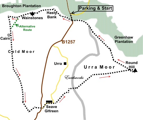
To view route as a dynamic Ordnance Survey map click here. Introduction: This Wainstones Walk takes you along a northern escarpment of the North York Moors, known as Hasty Bank, from where there are superb views over the surrounding plain with its patchwork of fields, towards Middlesborough and Roseberry Topping and over Bilsdale and Raisdale. Depending on the time of year, you may be rewarded by vistas of purple heather. The Wainstones are a prominent, dramatic outcrop of sandstone, at the western end of Hasty Bank and the largest such crag on these moors. They are popular with climbers. According to legend, a Danish chieftain was killed there. After walking along the ridge of Cold Moor, the route drops down to the hamlet of Seave Green before climbing to the trig. point on Urra Moor, the highest point in the North York Moors at 1490ft (454 metres). On the way, you pass through Billy's Dyke, an ancient earthwork some 3 miles long, which is marked on the OS map. Unlike many such features, this one is clearly visible. It is believed to date back to the Bronze Age. This walk is easy to navigate in the main as it follows well walked paths and tracks. However, the start involves a steep climb to the top of Hasty Bank, for which it earns a marginal red traffic light. There are no facilities en route, though there is a handy bench at Seave Green where you can stop for a picnic. The Cleveland Way is followed for part of the walk and here, this is a well manicured path of stone slabs. The walk starts from the large Forestry Car Park at Clay Bank, on the B1257, two and a half miles south-east of Great Broughton, at the junction of a road to Ingleby Greenhow (signposted). If you prefer there are a couple of rough lay-bys on the B1257, just beyond the car park. Start: From the car park (NZ 573036), turn left along the B1257. After a hundred yards or so, just after the brown tourist sign for Bilsdale, turn right to follow the fingerpost for “Cleveland Way” and “Carlton Bank 3½ miles”.
You now begin a steep climb along a “manicured” footpath paved with stone. After a quarter of a mile or so, the path levels out. Continue to follow the paved path to the unmistakable Wainstones at NZ 559036. All along here, you have great views north towards Teeside.
There is now a descent to the right of the centre of the stones. In the bottom of the valley, there is a footpath off to the left from a four way fingerpost, which cuts off a corner, or you can follow the same route as I did and climb the next hill. At the top of this, leave the Cleveland Way and turn left along a smaller path (NZ 551035), heading in the direction of the Bilsdale transmitter mast, which is clearly visible on the horizon. This takes you along the Cold Moor ridge and continues good views, both to the left and right over Raisdale.
At NZ 551028, pass a stone cairn.
At NZ 552016, there is a fork in the track. Go left. You approach a wall bordering a plantation. Follow the path by the wall to a double set of gates. Go through these and follow what looks like a sunken lane. Along this, look out for a stile on the left at NZ 558001. Cross the stile and at the field, follow the left hand boundary to the diagonally opposite corner where there is another stile. Cross this and turn right along a broad track. This takes you down to the road where there is a convenient bench for a picnic stop. Cross the road and follow the lane opposite in the direction of St Hilda’s Church. Follow the lane for a quarter of a mile and when it bends sharply left, turn off right on to a broad track following the Public Bridleway fingerpost. Stay on this track, ignoring a footpath off to the right after a couple of hundred yards. The track twists and turns a little and passes through the unmistakable Billy’s Dyke earthworks, at NZ 573010.
When the track forks, keep left following the wall on the left. Pass a long low stone building, shortly after which go through a gate to follow the Public Bridleway arrow. On meeting a broad grassy track (NZ 573010), turn right. Pass a double fingerpost then, at a three way fingerpost, turn left. On joining a broad stony track, in effect, go straight on passing a sign for the Nawton Tower Estate and then a long row of grouse butts. Stay on the track, ignoring a turn off to the right, until you meet a ‘Y’ junction by a boundary stone with “W V” on it. You are now on Round Hill. The route continues left here but you might like to visit the trig. point which is visible ahead. The easiest way to get to it, if you do not spot the faint track ahead through the heather, is to turn right until you get to an unusual marker stone on the left. The broad path by it leads to the trig. point.
From the trig. point, the direct path through the heather, back to the ‘Y’ junction, is more obvious. At the junction, turn right to follow the Cleveland Way back to the B1257 and the car park. The path is obvious and becomes paved after a while. If you need to buy any hiking equipment/clothing before your trip see the Hiking Store All information on this site is given in good faith and no liability is accepted in respect of any damage, loss or injury which might result from acting on it.
| | |||||||||||||||

.jpg)
.jpg)
.jpg)
%20View%20down%20first%20section%20of%20Cleveland%20Way.jpg)
%20View%20to%20Roseberry%20Topping.jpg)
%20Telephoto%20shot%20of%20Roseberry%20Topping.jpg)
%20View%20to%20Bilsdale.jpg)
%20View%20to%20Middlesborough%20&%20Teeside.jpg)
%20View%20of%20escarpment%20at%20Hasty%20bank.jpg)
%20Arrival%20at%20The%20Wainstones.jpg)
%20The%20Wainstones%20from%20below.jpg)
%20Panoramic%20view%20of%20Raisdale.jpg)
%20View%20from%20cairn.jpg)
%20Billy's%20Dyke%20earthworks.jpg)
%20Looking%20back%20to%20hasty%20Bank.jpg)
%20Boundary%20stone.jpg)
%20Round%20Hill%20Trig%20Point.jpg)