
|
|
|
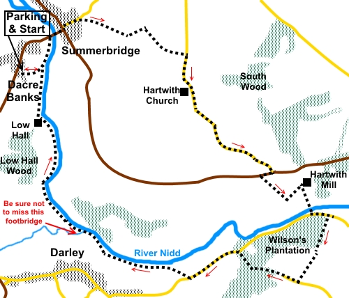
To view route as a dynamic Ordnance Survey map click here. Introduction: This Nidderdale walk takes you from Dacre Banks up through Summerbridge to the edge of Hartwith Moor. From here are great views up and across Nidderdale. Passing Hartwith Church, the walk drops into the valley to cross the River Nidd, via a toll road/bridge, something of a rarity but fortunately free to walkers! The route then climbs past Wilson’s Plantation to Swarcliffe, almost to Birstwith. Although this section could be bypassed by walking along the road, the climb is worth it for the great views across Niddedale to Simon’s Seat which is clearly visible. We then drop down to the river once more and enjoy a pleasant riverside path, back to Dacre Banks. St Jude’s Church at Hartwith is a Grade II listed building dating from 1751 but enlarged in 1830. There is a handy bench by the church should you want to stop for a picnic. On the last leg, we pass Low Hall, above you to the left, which dates from 1635. This really is a lovely walk which provides superb views for relatively little effort. As a bonus, if you are doing the walk during the blackberry season, take an appropriate container. You will pass masses! There is some road walking, primarily just over a mile past Hartwith church. However this is all downhill and very quiet. Less pleasant as more busy is a very short section of only about a hundred and fifth yards along the B6165 where you need to take care. The walk starts at Dacre Banks. This is on the B6451 Otley to Summerbridge road. Turn off the B6451 by the telephone box to the Royal Oak pub. There is a public car park opposite the pub. As a bonus, there is an opportunity for a great pint afterwards – highly recommended! Start: Turn right out of the car park (SE 197619) and after twenty yards, turn left between the cottages, following an old vertical style metal footpath sign, opposite the turn. After a few yards, go through a wider than usual farm gate and at a small stone barn, follow the broad track as it turns left. Enter a field and follow the right hand boundary. In the next field, bear left at about 45° to a walkers’ gate, through which you join the riverside path and turn left. Pass Dacre Tennis Club and at the bowling green, follow the path down the right hand side of the green to climb some steps to the B6451. Turn right to Summerbidge. Arrive at Summerbridge opposite the Flying Dutchman pub and climb Hartwith Bank road to its left. Pass most of the houses and just after the national speed limit sign and a drive to a house on the right, turn right to follow a bridleway indicated by a public bridleway fingerpost (SE 203625). The hedges path opens into a field. Follow the right hand boundary and cross a broad track to follow a bridleway sign next to Summerbridge Service Reservoir. Follow the obvious track through the trees, eventually becoming more open, with fine views across the valley. Ignore a junction with a path heading downhill, at the corner of a wall on the left and continue to follow the main broad track, as it bends left, now walled on each side.
Go through a gate to join a ‘T’ junction of wide tracks, with a stile to a footpath opposite (SE 211624). Turn right here following the fingerpost for “Hartwith”. At the road, turn right, downhill to meet the B6165, passing Hartwith church on the way.
Turn right along the B6165 and after about a hundred and fifty yards, turn left to follow a public footpath fingerpost (SE 224607). Walk down the right hand side of the field to start with but after around two thirds of the way down, head for the far left hand corner of the field. Here, go through the gate and walk between the buildings, curving left to follow the drive. The route is marked with yellow arrows. Cross two cattle grids and turn right at the next buildings (Hartwith Mill) following the blue bridleway arrow and sign for Toll Road. Follow the Toll Road and cross the river via the old iron bridge.
At the road junction, turn left along the road for two hundred yards or so, then turn right to follow the Nidderdale Way fingerpost for “Swarcliffe” (SE 232602). This is just before the village sign for Birstwith. The path climbs moderately steeply along the edge of Wilson’s Plantation. Over to the left are views of Nidderdale.
Exit the trees by the entrance to Bell House and follow its drive. Along here are distant views to upper Nidderdale and Simon’s Seat.
When you reach the tarmac lane, turn right following the Nidderdale Way fingerpost. At Reynard Crag mobile home park, the route goes down to the right hand side of the entrance. There is a blue bridleway arrow and an old style metal vertical sign. As you descend through the trees, keep close to the right hand wall to avoid being side tracked to a tempting track to the left. Go through a five-bar gate and leave the wall behind. Follow the obvious path through the trees which is laid with stone in the main. However, this stone can be slippy if damp, so take care. Follow the path down to the road (SE 222599) and turn left along it for a third of a mile. Ignore the first fingerpost on the right and pass Holme Barn and the post box, then turn right through a walker’s gate following the fingerpost for “Nidderdale Way” and “Summerbridge 2½ Miles”. Head for the diagonally opposite corner of the field and go through a gated stile. The path is now clear and takes you to the river where you turn left along the left hand bank back to Dacre Bank. Do not cross this footbridge.
However, there is another footbridge (SE 204601) after about half a mile which you must cross, over a beck, otherwise you will end up following this tributary to the River Nidd (as I nearly did!).
At SE 202603, note stepping stones which you ignore. On the way back, note Low Hall to the left.
If you are unsure of exactly where to retrace your steps, when you catch sight of the children’s playground, the walkers’ gate you passed through on the outward journey should be visible. If you need to buy any hiking equipment/clothing before your trip see the Hiking Store All information on this site is given in good faith and no liability is accepted in respect of any damage, loss or injury which might result from acting on it.
|
| |||||||||||||||||

.jpg)
.jpg)
.jpg)
%20Path%20through%20the%20woods%20near%20Summerbridge.jpg)
%20Looking%20up%20Nidderdale%20from%20the%20path%20to%20Hartwith.jpg)
%20Another%20view%20on%20the%20path%20to%20Hartwith.jpg)
%20Looking%20back%20along%20the%20bridleway%20to%20Hartwith.jpg)
%20Looking%20to%20NY%20Moors.jpg)
%20St%20Judes%20church%20Hartwith.jpg)
%20Hartwith%20Mill%20Toll%20Bridge.jpg)
%20Nidderdale%20from%20Wilsons%20Plantation.jpg)
%20Stinkhorn%20at%20Wilsons%20plantation.jpg)
%20View%20across%20Nidderdale%20to%20Simons%20Seat.jpg)
%20Telephoto%20shot%20to%20Simons%20Seat.jpg)
%20River%20Nidd.jpg)
%20Himalayan%20Balsam.jpg)
%20Footbridge.jpg)
%20Low%20Hall.jpg)