|
Elslack
To Pinhaw Beacon
|
Starting
point and OS Grid reference:

Car park opposite the Tempest Arms at Elslack
(SD 926498)
|
Ordnance
Survey Map
OL21
- South Pennines.
Buy this map from
List
of OS Maps
Commission from map sales is
used to fund the website, so keeping it free to use.
| |
Distance: 7.4 miles
| |
Traffic light rating:

(For explanation see My
Walks page)
| |


For advice on .gpx files see
My
Walks page
|

Click
the PDF logo above to give a printable version of this walk without the
photos.
|
To
view route as a dynamic Ordnance Survey map click here.
Introduction:
This
walk takes you over some of the same ground, on the Pennine Way, as the
Lothersdale Loop walk but in reverse order and overall is a shorter walk to
Pinhaw Beacon where there are 360° views and in particular long distance
views to Ingleborough and even the Lake District on a clear day. A bonus is
that on return, welcome refreshment can be had at the Tempest Arms (check
opening times).
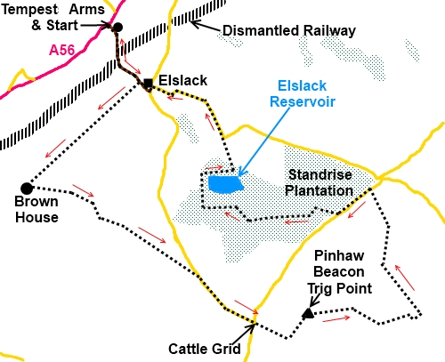
Start:
The
walk starts at the car park opposite the Tempest Arms (SD
926498). To get there turn off the A56 signposted “Elslack” and
“Lothersdale 5 miles”. The car park is immediately on the right.
Turn
right out of the car park and walk along the road. Cross over the brook,
ignoring the finger post to the left and at a large stone barn at Black Hall
Farm, turn right over a stile where indicated by a fingerpost (SD 929493).
Continue
to the far end of the field and in the left hand corner, go through a gate
where indicated with a footpath arrow. Once through that gate, turn right
through the second gateway on the left on to the obvious broad track
indicated by a yellow footpath arrow. Stay on the track ignoring any turns
and as the footpath ends, go through the narrow stile. Follow the line of
the wall then fence and across the ladder stile at the end of the field.
This
ladder stile has a footpath arrow indicating straight ahead (and slightly
left) but ignore this and once over the stile, turn abruptly left and follow
the field edge. You will see a kissing gate on the left bearing an acorn
sign indicating the Pennine Way. Go through this gate and ascend the field
keeping to the right hand side but stay on the higher part of the banking.
%20Ascending%20Fron%20Brown%20House.jpg)
%20Ingleborough.jpg)
At
the top of the field, go through a small gated stile turn 45° right and
ascend this field until you see two finger posts to the right hand side.
Cross the footbridge at this point and turn left.
%20Narrow%20footbridge.jpg)
%20PW%20Sign%20on%20Stile.jpg)
Continue
the gentle ascent via the wooden stepping. Follow the wall and over a stone
step stile with PW and an arrow on one of the treads (indicating Pennine
Way). Over the next ladder stile takes you to the road where you turn right
(SD 935475). At the ‘T’ junction, keep straight ahead on to the bridle
way signed “White Hills Lane 1¼ miles” and the “Pennine Way”.
At
the next finger post, just stay on the main track.
%20Lake%20district%20Hills.jpg)
%20Pinhaw%20Beacon.jpg)
You
arrive at the trig. point, a pleasant spot for lunch with great views (SD
944472). The route then continues straight ahead on the obvious path. Ignore
a fainter path on the left at a wooden post.
The
path descends gently and at the corner of two walls, turn left to follow the
wall walking over flagstones. These run alongside the wall and turn right at
a wall corner. Walk down to a gated stile and as you do, note the stone wall
running parallel on your left. You are going to walk up the other side of
this.
On
reaching the gated stile, do not be seduced by the footpath arrow and clear
path straight ahead but after crossing the stile, turn immediately left and
follow the wall. Next to a concrete water tank, there is a simple stone
stile to the left. Cross this and walk alongside the wall up the field on
the narrow footpath. Follow this path as it turns the corner and ignore the
small gate you come to in the wall. The wall leads you to the road where you
turn left over the cattle grid.
%20Track%20in%20Standrise%20Plantation.jpg)
Walk
along the road to Standrise Plantation but ignore the broad gated track at
its corner. Instead, walk a further 30/40 yards looking out for a finger
post on the right which indicates your way through the trees (SD 950484).
The
path arrives at a broad track. Turn left as indicated by a footpath arrow.
Stay on the main track ignoring any side turnings. It eventually swings
sharp right at a footpath post giving the option to go straight on but you
go right on the main track. Elslack Reservoir should now be visible through
the trees.
Follow
the track round the reservoir fording the outflow from it. If the volume of
water was such as to prevent you crossing, there is a concrete bridge above
the dam which could be utilised with a little fence climbing.
%20Elslack%20Reservoir.jpg)
Stay
on the main track as it curves below the house and exit into a track through
a metal gate. Turn left over the cattle grid and exit into the road at the
entrance to Standrise House. Turn left along the road.
At
the next road junction, turn left in front of The Grange and Grange Cottage
and right at the next. You will shortly see the large stone barn where you
turned off the road on the outward journey. Continue down the road to your
starting point.
If you need to buy any hiking
equipment/clothing before your trip see the Hiking
Store
All information on this
site is given in good faith and no liability is accepted in respect of any
damage, loss or injury which might result from acting on it.
|


.jpg)
.jpg)
.jpg)