|
Great Ouseburn Circular
Starting point and OS Grid reference:

Free
car park at Great Ouseburn village hall. (SE 446621)
|
Ordnance Survey Map
OS
299 - Ripon and Boroughbridge.
Buy this map from
List
of OS Maps
Commission from map sales is
used to fund the website, so keeping it free to use.
| |
Distance:
7.2 miles
|
Date of Walk:
12 December 2019
| |
Ascent:
Descent:
See Walking Time Calculator
|
399ft (121m)
399ft (121m)
| |
Traffic
light rating:

(For explanation see My
Walks page)
| |


For advice on .gpx files see
My Walks page
|

Click
the PDF logo above to give a printable version of this walk without the
photos.
|
To
view route as a dynamic Ordnance Survey map click here.
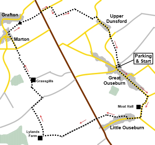
Introduction: This easy walk from Great Ouseburn is a circular route
across relatively flat countryside. It takes you through Great Ouseburn
itself, Little Ouseburn, the curiously named Marton-cum-Grafton and Upper
Dunsforth.
Great
Ouseburn, Little Ouseburn and Marton-cum-Grafton are conservation areas and
looking at the age of some of the buildings and varied architecture it is
easy to see why. The route takes you along the entire main street of Great
Ouseburn, starting with the Millennium Seat with its curious boulder said to
have been on the village green for centuries and gives a real appreciation
of the architecture.
The
route also passes the impressive Moat Hall at Little Ouseburn. It is
possible this was constructed on the foundations of a Roman house but
certainly its origins can be traced back to the 17th Century but
with numerous additions and alterations since.
You
will pass Holy Trinity church at Little Ouseburn which is worth a look, if
only to see the huge ashlar stone, circular mausoleum, built for Henry
Thompson of nearby Kirby Hall who died in 1760.
The
route passes the Punch Bowl Inn at Marton-cum-Grafton. This dates fro the 16th
century and is a cosy pub. I can vouch for the quality of its food and real
ale on the basis of my visit!
You
then come to Grafton Hill, where there is a trig. point. This was once the
site of an Iron Age Hill Fort and is a Scheduled Monument. Unfortunately it
has been badly affected by various quarrying and landscape changes over the
years but you can still get a sense of its ditch at one side. As you pass
the water tower, there are good views to the North York Moors and the White
Horse at Kilburn can be made out.
The walk starts from the village hall in
Great Ouseburn where there is a large car park. To get there, turn east off
the B6265, about four miles south of Boroughbridge. The village hall is a
fairly unmistakable modern building at the north end of the village.
Start: Exit
the car park and turn left down the main street. Immediately you see the
Millennium Seat with its large boulder. An inscription reads “Have More
Care To Stay Than Will To Go”.
%20Millenium%20seat%20at%20Great%20Ouseburn.jpg)
Follow
the road out of the village, crossing the beck via a footbridge alongside
the road bridge.
%20Road%20and%20footbridges%20at%20Little%20Ouseburn.jpg)
%20Holy%20Trinity%20Church,%20Little%20Ouseburn.jpg)
%20Thompson%20Mausoleum.jpg)
Continue
along the road and just past Moat Hall, turn right through a kissing gate
(SE 452610). Cross the field and at the road, turn right passing the village
hall.
%20Moat%20Hall,%20Little%20Ouseburn.jpg)
%20Village%20Hall,%20Little%20Ouseburn.jpg)
Turn
right up Back Lane, opposite the house “The Forge”.
Follow
the lane along and the rough track which continues it, to the far side of
the first field. Follow the track round to the left, keeping the hedge on
your right.
At
the road, cross straight over along the broad track towards Lylands Farm, in
the direction of an old style, metal public footpath marker.
%20Countryside%20on%20the%20outskirts%20of%20Little%20Ouseburn.jpg)
Just
before the farm’s gate, turn right into the field following the public
footpath fingerpost for “Moor Lane ½ mile” (SE 427603).
Follow
the right hand boundary and at the corner, branch off left slightly to a
gate opposite with a yellow arrow.
In
the two fields beyond the gate, follow the right hand boundaries. At the end
of the second field, join a broad tarmac track and turn right (SE 424610).
On the day I dad the walk, this point was marred by the most appalling dump
of mixed rubbish!
Continue
along the track for a quarter of a mile. The next turn has little to
recognise as it is merely a gap in the hedge. Look out for a farm across a
couple of fields to the left (Grassgills). Turn off through the gap, just
before a slight bend in the track which to this point has been straight.
Head initially, for the right hand corner of a wood.
At
the corner of the wood, follow the track as it bears right to the farm.
As
you enter the farmyard, keep straight ahead between the buildings, to the
far side of the field beyond.
The
continuation of the route means finding the stile, which is well hidden
behind the hedge (SE 421623)! Go through a gap then immediately left to find
it. If you have kept a straight line from the farm you should find it.
In
the field beyond the stile, follow the left hand boundary to the far side
where a dog-leg right then left takes you through a gateway.
Follow
the obvious track to the road. Go straight across and along Reas Lane into
Marton. At the junction by the telephone box, turn right.
%20Christ%20Church%20Marton%20cum%20Grafton.jpg)
%20Punch%20Bowl,%20Marton%20cum%20Grafton.jpg)
To
the right of the Punch Bowl pub, turn right, following a public footpath
fingerpost for “Grafton via Playing Fields.
Follow
the path down to a kissing gate where there are several paths. Keep straight
ahead up more steps, to the left of the fence.
At
the top of the steps at a cross roads of paths, keep straight ahead.
The
path leads to the trig point which is up steps on the left (SE 421632).
Return from the trig point, at the bottom of the steps circle clockwise
round the water tower.
%20View%20over%20playing%20fields%20at%20Grafton.jpg)
%20Steps%20to%20the%20trig%20point%20at%20Grafton.jpg)
%20Water%20tower%20at%20Grafton.jpg)
At
a cross roads of paths just beyond the water tower is a public footpath
fingerpost, indicating a route across the field. However based on evidence
on the ground, the convention here is obviously to follow a well worn track
down the right hand side of the hedge to the road. This will avoid damaging
any crops and is marginally shorter than taking the “official” route.
%20View%20to%20the%20North%20York%20Moors.jpg)
%20White%20Horse%20Kilburn.jpg)
At
the road (B6265) cross straight over and down the single track road.
In
less than a quarter of a mile, just after a passing place, take a broad
track on the right to Hundayfield Cottages.
Pass
the cottages and at the farm, go between the first two buildings and on
reaching the centre of the complex, turn left.
Once
through the farm, follow the left hand boundary of the field. Almost at the
end of the field, come to a gate on the left. Go through it and turn
immediately right.
Go
through a gate opposite in the next field then bear right at about 45° to a
gate at the corner of fencing. Through this, follow the obvious track
straight ahead.
The
track emerges into a road. Turn right to walk through Upper Dunsford. At the
‘T’ road junction, cross to follow the obvious path in a straight line
across the field opposite, which returns you to Great Ouseburn village hall.
If you need to buy any
hiking equipment/clothing before your trip see the Hiking
Store
All information on this
site is given in good faith and no liability is accepted in respect of any
damage, loss or injury which might result from acting on it.
|


.jpg)
.jpg)
.jpg)