|
Leyburn to Wensley via Leyburn Shawl
Starting point and OS Grid reference:

War
Memorial in Leyburn Market Place (SE 112906)
|
Ordnance Survey Map
OL
30 – Yorkshire Dales - Northern and Central.
Buy this map from
List
of OS Maps
Commission from map sales is
used to fund the website, so keeping it free to use.
| |
Distance:
6.1 miles
|
Date of Walk:
25 October 2018
| |
Ascent:
Descent:
See Walking Time Calculator
|
708ft (216m)
709ft (216m)
| |
Traffic
light rating:

(For explanation see My
Walks page)
| |


For advice on .gpx files see
My Walks page
|

Click
the PDF logo above to give a printable version of this walk without the
photos.
|
To
view route as a dynamic Ordnance Survey map click here.
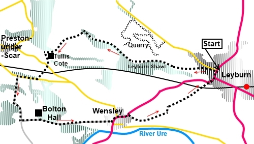
Introduction: This walk from Leyburn to Wensley takes you via the
curiously names Leyburn Shawl to Wensley, then back to Leyburn. The views
over Wensleydale from Leyburn Shawl, a limestone escarpment, are truly
magnificent and you can clearly see Roova Crags, Pen
Hill and Addleborough.
There is a topograph setting it all out.
The
legend version behind the name Leyburn Shawl is that Mary Queen of Scots was
imprisoned at Castle Bolton, around 5/6 miles west of Leyburn. One day, she
managed to escape and fled through woodland, along this escarpment, towards
Leyburn. Her shawl caught on a
branch, where it was found by pursuing soldiers, so indicating that she had
passed that way. The escarpment has thereafter been known as Leyburn Shawl
or just The Shawl.
An
alternative story is that “Shawl” comes from Old Norse schalle or skali
which refers to huts or shelters. You do pass the site of an ancient
settlement along this route. Or it may come from Shaw, meaning wood. In
essence, no one knows!
Prehistoric
remains have been found here. The Shawl was used to host annual tea parties
in the 19th Century
You
pass the impressive Bolton Hall which is home to Lord Bolton and has been in
the family since 1149. It is the centre of a large estate, with a history of
mining, quarrying agriculture and forestry. The house and gardens are
private though the gardens have periodically been opened to the public.
You
will also pass the remains of the Keld Heads Smelt Mill. Derelict and
looking non too safe, especially the chimney, there are the remains of the
engine house and another building. If you look to the right, there are the
remains of the wheel pit. Production began in 1851. By 1859 its flue had
been extended to a length of 3.3 kms, making it the longest in Yorkshire!
Production ceased around 1888.
Wensley
is a small, pretty village from which the dale gets its name, unlike other
dales which take their names from the rivers which run through them. In this
dale, the river is the Ure. Wensley received its market charter in 1202 and
held the only market at that time. It boasts a fine pub, the Three
Horseshoes and the White Rose Candle Workshop where as well as buying
candles, you can watch them being made.
The
walk starts from the war memorial in the market place in Leyburn, which is
on the A684, the main road through Wensleydale. There is parking in the
market place area and there is also a pay and display car park.
This walk could be combined with my
Harmby to Middleham walk by diverting at Wensley. This would give a round trip of about 11 miles.
Start: With
your back to the war memorial,
cross High Street and walk along Commercial Square. Close to the end, you
will see a sign for “The Shawl”. At the end of the street, turn left and
almost immediately right through a kissing gate and follow the path ahead
through the field in front of the houses, known as Shawl Fields. You have
now started crossing the top of the escarpment known as Leyburn Shawl.
%20View%20from%20Leyburn%20Shawl%20to%20Pen%20Hill.jpg)
%20Looking%20along%20Leyburn%20Shawl.jpg)
%20View%20down%20Wensleydale%20from%20Leyburn%20Shawl.jpg)
At
the end of the field, go through a walkers’ gate and follow the path along
the edge of the trees.
%20Autumn%20path%20along%20Leyburn%20Shawl.jpg)
%20View%20up%20Wensleydale%20from%20leyburn%20Shawl.jpg)
Continue
along the top of the escarpment, ignoring a path off left at SE 093910.
Eventually,
the path you are following dips down to the left (SE 086913).
Arrive
at a three way fingerpost (SE 086913). Turn left, following the fingerpost
for Preston-under-Scar and continue down the field to a kissing gate you can
see.
Pass
the corner of a fenced off rough area (SE 081912). Go left at the corner
following the direction of a yellow footpath arrow.
Continue
down, to the gate and beyond, ignoring a track off to the right which goes
to Preston-under-Scar.
Follow
your track until it bends right towards the trees. Almost immediately, cross
another broad track and go through the gateway towards the farm.
%20Unusual%20barn%20at%20Tullis%20Cote.jpg)
Start
anti-clockwise around the farm (Tullis Cote) but as you reach the corner of
a barn, where the main track bends left towards the farmhouse, branch off
right, on to a footpath, just before a power pole.
The
path develops into a broader track. Follow it down past the remains of Keld
Heads Smelt Mill.
%20Remains%20of%20Kelds%20Head%20smelt%20mill.jpg)
%20Chimney%20at%20Keld%20heads%20smelt%20mill.jpg)
%20Remains%20of%20wheel%20pit.jpg)
Follow
the main track down past the cottage to the road, crossing Keld Bridge.
Cross the road and keep straight ahead following the public footpath
fingerpost. A little further on, cross the railway and follow the path to
another road where you turn right (SE 077905).
Opposite
the house “Stoneham” (shown as Stoneham Cottage on the OS map), turn
left down a broad concrete drive (SE 073905).
At
a ‘T’ junction of tracks, turn left, then follow it as it bends right
alongside a high stone wall. Continue past Bolton Hall.
%20Bolton%20Hall.jpg)
At
a crossroads of tracks, turn left, passing the front of Bolton Hall with its
ornate black and gold gates. At the next junction, the left turn is the
private drive to the house, so you turn right.
Arrive
at the main road in Wensley (SE 092897) and turn left along it.
Follow
the main road out of the village, passing the Three Horseshoes Pub
(excellent beer!) and the candle makers. Just after you have passed the
village sign for Wensley, turn right down a tarmac lane, going back on
yourself. Look out on the left for a public footpath fingerpost and follow
the direction into a field (SE 095898).
Initially,
follow the power lines across the field. At the bottom of the field, by a
small barn, turn left and follow the hedge on your right.
Cross
a small field, then go through a kissing gate. Bear left to go round the top
corner of a wood (SE 100897).
Follow
the edge of the wood to a kissing gate, through which you enter the Leyburn
Old Glebe Nature Reserve. Cross a small bridge, then turn left.
At
the end of the field, go through a slit stile keeping straight ahead in the
dir4ection of a yellow arrow, parallel with the left hand field boundary.
As
you get near the top of the field, turn right to head for the top right hand
corner of the next field, where there are two gates. Go through the right
hand gate and follow the hedge on the left.
A
combination of easily discernable path, gates and stiles now guide you to
Leyburn. Cross the railway once again and head for the opposite corner of
this last field. Turn right along the road into Leyburn.
If you need to buy any
hiking equipment/clothing before your trip see the Hiking
Store
All information on this
site is given in good faith and no liability is accepted in respect of any
damage, loss or injury which might result from acting on it.
|


.jpg)
.jpg)
.jpg)