
|
|
|
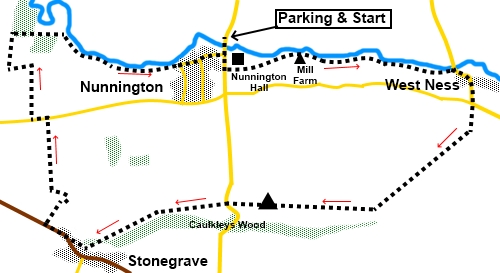
To view route as a dynamic Ordnance Survey map click here. Introduction: This is an easy walk in the Howardian Hills Area of Outstanding Natural Beauty (AONB), starting from Nunnington and along Caulkleys Bank, which affords wide ranging views, before reaching the pretty village of Stonegrave. Nunnington is a quiet attractive village best known for Nunnington Hall, a National Trust stately home. After a stroll along by the River Rye, the route passes via the hamlet of West Ness before passing along Caulkleys Bank, following the course of an ancient lane atop this south facing escarpment. There are wide ranging views over the Vale of York. Its trig. point is at a mere 315ft (96m) but the views make it feel higher. There is a bench next to the trig. point, which makes for a great lunch stop, as you admire the view. Unfortunately, I hit a hazy day, which rather restricted it but hopefully the photos will give you some idea of what to expect. Stonegrave is a pretty spot as you descend from Caulkleys Bank. Apart from some lovely properties, there is not a lot there except for a nice church and unusual church. It is unusual in that it is a Minster, the smallest in the country (a good quiz question?). “Minster” was a title bestowed upon particular churches which were a monastery in ancient times. They were run by celibate monks or nuns. Eventually the term came to refer to large or important churches. Stonegrave served a wide area. It is known to have been on the site since 757, although it has been remodelled a few times over the centuries, the last time being in 1863. It has a rather fine stained glass window. A further stretch of the River Rye returns you to Nunnington. The walk starts from a rough parking area just yards north of the river bridge in Nunnington, or you could park in the National Trust car park across the road. The easiest route to describe there is to turn off the A170, on a sharp bend at Sproxton, on to the B1257, following the brown tourist sign for Nunnington Hall. After three miles, turn left, again following a brown tourist sign for Nunnington Hall and follow similar signs until you get there. From the south, you can join the B1257 at Malton and follow the signs for Nunnington Hall. Start: Cross the bridge and walk up the hill. Just past the village hall, immediately after passing the sign for the Howardian Hills, cross a stile on the left and turn left following the direction of the yellow arrow (SE 669793). Pass Nunnington Hall.
At the end of the first field, go through a gate keep straight ahead to the gate at the end of the next one. Keep straight ahead to pass between the buildings at Mill Farm. Once through the buildings, you will see a high stone wall ahead. The path runs along its left side. At the end, go through a kissing gate and follow the yellow footpath arrow. A series of yellow arrows and kissing gates guide you, essentially following the right hand bank of the River Rye. You will notice a fishing lake at the opposite side of the river.
You arrive at the road at West Ness (SE 688794). Turn right along it. Follow the road as it bends left, then right and turn off it to the right to follow a bridleway fingerpost for “Stonegrave 2½ miles” (SE 689790).
After about three quarters of a mile, come to a broad stony track. Turn left for a few yards then turn right following a public bridleway fingerpost. You are now on Caulkleys Bank with good views to the south over the Vale of York.
After half a mile, arrive at the trig. point with the adjacent bench (SE 672782).
Continue along the track to the road (where there is another bench). Cross and keep straight ahead on the continuation of the track. You arrive at a three way fingerpost, where you can turn right to return to Nunnington, should you wish to shorten the walk but otherwise, keep straight on for “Stonegrave ½ mile”. At SE659779, the path goes over a stile and starts to descend. There is a lovely view down towards Stonegrave and a log seat.
At the road, to see Stonegrave Minster, turn left then first right but otherwise, the route continues by turning right at the road. After passing all the cottages on the right and just before the national speed limit sign, turn right following a public footpath fingerpost for “Nunnington 1¼ miles” (SE 654780). Follow the right hand boundary to the top of the field and turn left, now following the boundary on the right. At the corned, turn left and follow the track as it turns right across the top of another field. Just to clarify, you have walked in a sort of rectangle around the top of the first field.
Continue in the same direction until you reach the road and turn left along it. After around a hundred and fifty yards, turn right following a public footpath fingerpost for “Harome 2 miles” (SE 653789). Follow the broad track as it bends sharp left then right. As you reach some trees, turn right for “Nunnington ¾ mile”. Follow the obvious route as it curves left, then right at the end of the field. At the end of the next field, turn right over a footbridge before turning left to follow the right hand bank of the river. You reach the road on the outskirts of Nunnington. Keep straight ahead through the village emerging at the river bridge. Go left over it to return to the parking.
If you need to buy any hiking equipment/clothing before your trip see the Hiking Store All information on this site is given in good faith and no liability is accepted in respect of any damage, loss or injury which might result from acting on it.
| | |||||||||||||||||

.jpg)
.jpg)
.jpg)
%20Nunnington%20Hall.jpg)
%20River%20Rye%20and%20Fishing%20Lake.jpg)
%20View%20over%20the%20Vale%20of%20York.jpg)
%20Another%20view%20over%20Vale%20of%20York.jpg)
%20Oil%20Seed%20Rape.jpg)
%20Trig%20point%20and%20bench%20on%20Caulkleys%20Bank.jpg)
%20Starting%20the%20descent%20to%20Stonegrave.jpg)
%20Approaching%20Stonegrave.jpg)
%20Outskirts%20of%20Stonegrave.jpg)
%20Stonegrave%20Minster.jpg)
%20Stained%20glass%20in%20Stonegrave%20Minster.jpg)
%20Cowslips%20by%20the%20footpath.jpg)
%20Nunnington.jpg)