
|
|
|
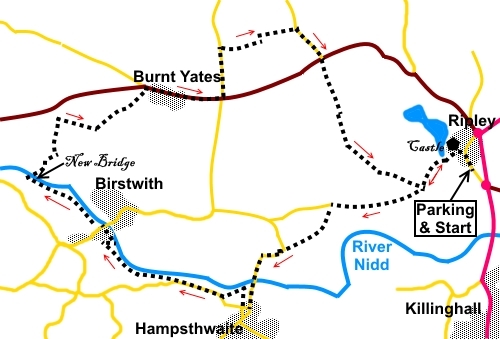
To view route as a dynamic Ordnance Survey map click here. Introduction: This walk from Ripley is an easy 9 mile circuit with little climbing/ascending. The paths/tracks are mostly obvious on the ground and the first section follows the course of the Nidderdale Way. There is some roadwalking but the roads are generally quiet. Ripley itself is a smart, picturesque village dominated by Ripley Castle which is open to the public and still owned by the Ingleby family, after 700 years or so. In the centre is a cobbled square and cross, with stocks if you misbehave! The route works its way down to the River Nidd at Hampsthwaite. This is a large attractive village with a village green. It was awarded a charter to hold an annual market as long ago as 1304. It has a fine church dedicated to St. Thomas a Becket. The village was the ancestral home of William Makepeace Thackery, who wrote Vanity Fair. The river bridge was built in about 1640 but there had previously been a ford there which was on the route of the famous Roman road Watling Street. The route then passes Birstwith before curving round to Burnt Yates and back to Ripley. There are refreshment opportunities at the Joiners Arms or Nelson Inn in Hampsthwaite, the Station Hotel Birstwith or the New Inn in Burnt Yates but check opening times The walk starts from a free car park at Ripley, where there are public toilets. To get there, turn west of the A61 at a roundabout, between Harrogate and Ripon (signposted). My walk was on rather a dull day so apologies for the rather flat photos. Start: Turn left out of the car park and in the centre of Ripley (SE 284603), where the market cross is situated, turn left to follow the Nidderdale Way.
Follow the tarmac path along past the castle. Not far past the castle, a footpath goes off to the right. This will be your return path but ignore it for now and continue on the tarmac path. After going through a gateway, continue straight ahead for Hampsthwaite and Burnt Yates. About fifty yards further on, take the narrow footpath off to the left following the fingerpost for the Horseshoe (SE 269600).
At the road (SE 264595), turn left and follow it to Hampsthwaite.
In Hampsthwaite, at St Thomas a Becket Church, you could turn right through the churchyard to cut off a small corner but it is worth carrying on past the church and turning right at the first junction, by the village green. Here, there is an impressive, cast information board/map, on a stone plinth, which gives you information about the village. Continue on past the information board, following the Nidderdale Way, for a few yards and turn right following a public footpath fingerpost which takes you through a garden (SE 259588), to a small stone stile.
Cross the stile, then a second one. Keep straight ahead to the right hand side of the churchyard and go between some impressive gateposts. Follow the path to the church and turn left to follow the narrow tarmac footpath, as it curves round to a walkers’ gate and a sign which informs you about the Medieval Way. This is an ancient pathway, linking the churchyard with the Birstwith Road. When you reach the road, turn right.
By an old barn, turn right following the fingerpost for Birstwith (SE 252591). This path leads down to the River Nidd. When you get to it, turn left to follow the bank. The path follows the river closely for just over a third of a mile before veering away (SE 246594). Just before arriving at industrial units, turn right through a walkers’ gate, to rejoin the river. Follow the path to the road and continue to follow the river at the other side. Follow the river until you reach an impressive packhorse bridge, called New Bridge, with its cobbled surface (SE 236601). It is a Scheduled Ancient Monument which is on an old route from Fountains Abbey. Cross this, then over the course of the old railway and climb the slight hill at the other side.
Go through a farm gate and follow the left hand field boundary, passing under some power lines. At a wall corner, a bridleway goes off to the left but you go straight ahead through the gate. Follow this path and take a right turn, indicated by a public footpath fingerpost and crossing a wooden stile (SE 239609). To the right along here are views over the Nidderdale and Birstwith.
Cross a field to a walkers’ gate and go over the cattle grid along a tarmac drive towards Dinmore Barn. Half way down this drive, the footpath forks to the left over a stile in the drive fence. Pass to the left hand side of the barn which has been converted into a dwelling. Through the gateway (SE 243608), turn immediately left to follow the left hand boundary of the next three fields, exiting into the road on the edge of Burnt Yates via a stone stile (SE 249613). Turn right along the road. Just after the school, there is a footpath on the left, marked with a fingerpost (SE 252612), which you could use to cut off a corner (turn off right after about a third of a mile to join a road). However, in the hopes of a beer, I continued half a mile along the road to the New Inn, at the next cross roads. Unfortunately it was closed so I turned left at these crossroads. Nevertheless, the stroll along the road was not wasted as there were good views off to the left stretching as far as the North York Moors and the White Horse at Kilburn was clearly visible even though it was a dull day.
The road sign at the crossroads is for Shaw Mills and Bishop Thornton. After a third of a mile, turn right to follow leave the road and follow a public footpath fingerpost (SE 257617). If you have used the short cut mentioned in the previous paragraph, on meeting the road, turn left and almost immediately right. At Manor House Farm, turn right along the drive. Follow it to the road, then turn right along the road. At a ‘T’ road junction with the B6165, cross straight over it, following the public footpath fingerpost, through an impressive pedestrian gate (Se 268616). Cross a small stile and follow the field boundary straight ahead. Pass through a couple of gates and cross a field with a power line. Here, follow the fence on the right. Go through a kissing gate and follow the wall on the left. At a ‘T’ junction of tracks, turn left along a broad track. Pass a dilapidated sign for Monks Cross. I could not see this amongst the trees but maybe missed it. It is marked on the OS map. Stay on this track until after just over half a mile, you rejoin the track of your outward journey from Ripley. Turn left back to the village. If you need to buy any hiking equipment/clothing before your trip see the Hiking Store All information on this site is given in good faith and no liability is accepted in respect of any damage, loss or injury which might result from acting on it.
| | |||||||||||||||

.jpg)
.jpg)
.jpg)
%20Market%20cross%20and%20stocks%20Ripley.jpg)
%20Lake%20overspill.jpg)
%20Ripley%20Castle.jpg)
%20St%20Thomas%20a%20Becket%20church.jpg)
%20Village%20Green%20Hampsthwaite.jpg)
%20View%20SW%20near%20Hampsthwaite.jpg)
%20New%20Bridge%20and%20River%20Nidd.jpg)
%20Countryside%20View.jpg)
%20View%20to%20NY%20Moors.jpg)
%20White%20Horse.jpg)