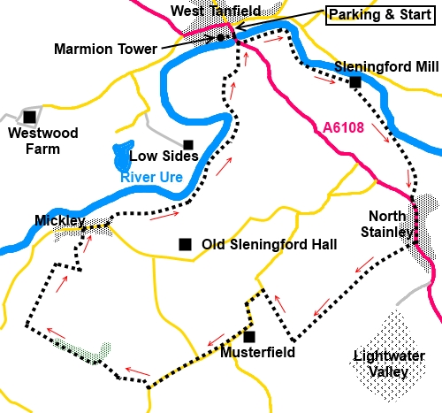
|
West
Tanfield Circular Walk and The Marmion Tower
|
Starting
point and OS Grid reference:

Free
car park (donations) (SE 269788)
|
Ordnance
Survey Map
OS
Explorer 298 - Nidderdale.
Buy this map from
List
of OS Maps
Commission from map sales is
used to fund the website, so keeping it free to use.
| |
Distance:
7.8
miles
| |
Traffic light rating:

(For explanation see My
Walks page)
| |


For advice on .gpx files see
My
Walks page
|

Click
the PDF logo above to give a printable version of this walk without the
photos.
|
To
view route as a dynamic Ordnance Survey map click here.
Introduction:
This walk from West Tanfield in North
Yorkshire, makes use of some of the Ripon Rowel route at the beginning and
end with a “cross country” section in between. The Ripon Rowel walk is a
long distance footpath of some 50 miles in the countryside around Ripon.
West Tanfield is a very attractive village
and the view from the bridge frequently crops up as a “Yorkshire”
picture on calendars etc. The Marmion Tower sits alongside St Nicholas
Church. The Tower, built between 1350 and 1400, is in the care of English
Heritage and was the gatehouse to a long lost manor house. It is free to
look round the Tower. If this was only the gatehouse, one can only wonder
how grand the house itself must have been. There is an impressive projecting
oriel window from which there are nice views. You need to take care on the
spiral staircase. As a matter of interest, did you know that spiral
staircases in castles etc almost always go anti-clockwise on the descent so
that anyone defending against an intruder has the advantage with a sword.
St Nicholas Church is quite impressive too
and contains effigies of Sir John and Lady Elizabeth Marmion. He died in
1387, fighting in Spain and his wife may have lived in Marmion Tower after
his death.
The walk follows the River Ure for some of
its length. There is some road walking – a short stretch on the main A6108
through North Stainley, though worth it, to see the village ponds and the
old toll booth and a mile section on a very quiet road before reaching the
tranquil village of Mickley.
The walk is very easy with little in the way
of gradient. Good views across to the North York Moors.
The walk starts from the free car park at the
West Tanfield Memorial Hall, immediately to the north of the river bridge.
Donations requested. West Tanfield is on the A6108 between Ripon and Masham.
The best spot for a picnic is probably about
half way round the walk, after you turn off the road beyond Musterfield.
There are a few rocks on which to sit by the side of the path.
Start:
From the car park (SE 269788), cross the road and walk along Church Street,
alongside the Bull Inn. The Marmion Tower is at the end of the street, on
the left of the Church.
%20St%20Nicholas%20Church%20and%20the%20Marmion%20Tower.jpg)
%20Marmion%20Tower.jpg)
%20Inside%20Marmion%20Tower.jpg)
%20Oriel%20Window.jpg)
%20Inside%20St%20Nicholas%20Church.jpg)
%20Effigies.jpg)
Retrace your steps to the main road and turn
right over the road bridge. Immediately after crossing it, turn left to
follow the right hand bank of the River Ure, in the direction of the Ripon
Rowel fingerpost.
%20West%20Tanfield.jpg)
%20Weir%20near%20West%20Tanfield.jpg)
The path follows the riverbank for about half
a mile before joining a tarmac track which leads to the Sleningford
Watermill Caravan Park (SE 277784). Turn left and follow the track to the
complex of buildings. The old watermill is on the left and chatting to the
site manager, I learned that it is probably 18th century and that
all the machinery is still in place. It may be restored in the future.
%20Sleningford%20Mill.jpg)
The public footpath exit from the building
complex is to the right of the reception. There is a yellow arrow on a post.
In the field beyond, keep to the slightly raised, flattened, grassy area to
the right. It leads to a walkers’ gate after which, turn left.
As you approach the next group of buildings
(Sleningford Grange), the footpath goes left through a gate and drops down
the banking, to circle clockwise around the property. This is a diversion
from the route on my OS map and the route of the old path inside the fencing
was still visible.
%20River%20Ure%20near%20Sleningford%20Grange.jpg)
You will come to another walkers’ gate on
the right. Go through this and follow the path to the main A6108 at North
Stainley (SE 286773). Turn left to walk along the road, now leaving the
Ripon Rowel route.
North Stainley has a number of village ponds,
the largest on the left having an information board outlining the wildlife
you might see. The church St Mary The Virgin was closed when I passed but
has intricately carved stonework around the doorway, now protected by a
porch.
%20Village%20pond%20North%20Stainley.jpg)
Continue along the road and turn right at
Cock Pit Close (SE 286768), following the Public Bridleway fingerpost.
Before you turn however, if you look ahead along the main road, there is a
curious small round building you might want to investigate. There is no
information about this but it is no doubt an old toll booth.
%20Old%20toll%20Booth%20North%20Stainley.jpg)
At the fork in Cock Pit Close, keep right and
go through the walkers’ gate at the end. Keep to the left of the field
beyond and straight ahead on the broad track, once you have gone through the
5 bar gate at the end.
The track climbs very gently and behind you,
views of the North York Moors start to appear. Pass a quarry on the left and
follow the track as it bends right at 90° (SE 275759) (the public bridleway
seems to have been diverted by quarry workings, no longer going through
Musterfield). Views of the NY Moors are better along here. At the road, turn
left.
%20Views%20to%20NY%20Moors.jpg)
You now walk along this quiet road for a
mile, forking right at the first junction and ignoring the right turn for
Mickley – we are going there but I preferred footpaths to minimise road
walking.
Stay on the road until it does a sharp left
hand turn. On the bend, turn right following the Public Bridleway fingerpost
(SE 262755).
At the end of the first field, go through a
gate, marked with a blue bridleway arrow and shortly at a junction of
bridleways, go straight ahead ignoring the one going left. There are a few
large stones along here where you could perch for a picnic.
Stay on the right hand side of the field and
through a gate at the end, to enter a wood. The path meanders along its left
hand boundary. Judging from the bulb leaves, it looks as though this will be
a riot of blue in the bluebell season, though I was a little early.
Leave the woods through a gate
[It has been reported in 2023 that this gate was locked but it is a Right of
Way and should not be!] where there is
a right hand turn, indicated with a yellow arrow, which you ignore. A few
yards further along, note the fence line to the right, descending the slope
(SE 250761). Turn right here, keeping to the right of the fence. It drops
down, then climbs the banking, going right to a double set of farm gates.
Go through both gates. The continuation of
the path runs along the left of the field boundaries, to the left of the
gates, for the next two fields. At the bottom of the second field, turn
right through a gate, following the yellow arrow (SE 253767).
%20Approaching%20Mickley.jpg)
Over a small stile and ahead is a barn (SE
255766). Proceed to this then turn left, descending a wide track. At the
junction of tracks where left clearly goes to the farm buildings, turn
right, coming out at the road by Mickley Village Hall. Turn right here.
As the road bends right to leave the village
(SE 258770), turn left by a bench, to rejoin the Ripon Rowel walk, clearly
signposted. You enter a field and need to keep just to the right of the line
of trees running ahead of you, along the middle of the field. Go through the
gap in the woods ahead and bear left after the gate.
Stay on the Ripon Rowel walk route, ignoring
one right turn by a dilapidated wall and another further on. Keep following
the river [it
was reported in September 2023 that this section is poorly maintained and
obstructed by high bracken. You may wish to take this into account according
to the time of year]. You pass an interesting seat cum art installation.
%20Seat%20or%20artwork.jpg)
%20Colourful%20bushes.jpg)
As the river bends very sharply away from you
(SE 269780), just by Quarry House Farm, the footpath route crosses two
fields diagonally. However to save crops, I walked along the right hand edge
of the two fields, then turned left along the boundary of the second to join
the broad track to the farm. A right turn here takes you to the bridge at
West Tanfield. Note the precarious steps up it to the old stile – stick to
the track!
%20Approaching%20West%20Tanfield.jpg)
If you need to buy any
hiking equipment/clothing before your trip see the Hiking
Store
All information on this
site is given in good faith and no liability is accepted in respect of any
damage, loss or injury which might result from acting on it.
|


.jpg)
.jpg)
.jpg)