|
Fontburn
Reservoir Walk
|
Starting
point and OS Grid reference:

Fontburn
Reservoir – Car park on north side of reservoir (NZ 047939)
|
Ordnance
Survey Map
OL
42 – Keilder Water Bellingham and Simonside Hills.
Buy this map from
List
of OS Maps
Commission from map sales is
used to fund the website, so keeping it free to use.
| |
Distance: 6.2 miles
| |
Traffic light rating:

(For explanation see My
Walks page)
| |


For advice on .gpx files see
My
Walks page
|

Click
the PDF logo above to give a printable version of this walk without the
photos.
|
To
view route as a dynamic Ordnance Survey map click here.
Introduction:
The Fontburn Reservoir walk is a
mixture of pretty waterside walking and wide open spaces. The going is
straightforward but can be muddy in places during/after wet weather. There
are attractive views for most of the walk not least towards the Simonside
Hills. There is a chance of seeing some interesting birdlife including pied
flycatcher, redstart and lapwing. I was fortunate to see a vole.
Fontburn Reservoir
is in the valley of the River Font and was completed in 1908 to provide
water for the Morpeth and Bedlington areas. It also provides a pleasant
trout fishing opportunity (licences available at the shop).This walk starts
from the free car park by the reservoir and makes use of the waymarked
footpath by its southern shore, created by Northumbrian Water.
You will see the term “Bastle” on the OS
map. Bastles were fortified farmhouses built in the late 16th and
early 17th centuries to protect local people from raiders. This
walk passes two such sites but to be honest, they were something of a
disappointment and have largely been “redeployed” into the existing
farmhouses. According to the Northumbrian Water information board at
Fontburn Reservoir, there is a cup and ring marked rock en route. I
identified a rock which had what might have been “cups” on its top
(though saw no rings) but whether these were man made or natural erosion, I
leave to you!
There were a couple of “interesting”
stream crossings which I go into in more detail below.
To get to Fontburn Reservoir, turn west off
the B6342 at a sharp bend, about 6¼ miles south of Rothbury. It is
signposted by a brown tourist sign from the road “Fontburn 2 miles”.
There are two car parks and I started this walk from the one reached by
turning right over the reservoir dam then left.
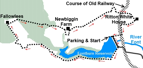
Start:
Cross the dam and turn right along the southern shore of the reservoir. When
you are well along it, the path diverts away from the water to avoid a
nature reserve. The diversion is clearly signposted.
%20Water%20treatment%20plant%20at%20Fontburn%20Reservoir.jpg)
%20Fontburn%20Reservoir%20and%20Simonside%20Hills.jpg)
You pass a large rock which may or may not be
a cup and ring rock, the path bends to the right, then left towards a marker
post on the horizon (NZ 031935).
%20Cup%20and%20Ring%20Rock.jpg)
From the marker post turn right and follow
the path along the bank top as it curves rounds to the left. It crosses a
ladder stile which you wall see ahead.
Once over the stile, the path bends left to
another marker post and is an obvious track. The next turn is a little
difficult to spot (NZ 023936). You will see Fallowlees Farm over to the
right which is your destination and you need to look out for a marker post
over to the right marking a different route to the yellow topped posts you
are following. Turn right here. The track to the farm is obvious. It swings
left then over a footbridge across a pretty stream. Once over this, go up
the hill to the right.
%20View%20to%20Simonside%20Hills.jpg)
%20Wide%20Open%20Spaces.jpg)
At the farm (NZ 019943), turn right to walk
in front of the farmhouse. Here is the first “Bastle” marked and next to
the farm you can just spot some large stones comprising the remnants of the
corner of a wall which look to be all that remains.
The exit from the farm is in the right hand
corner after passing the barns. As you then enter a large field, the route
is via a gate about half way along the opposite wall.
You enter a plantation area where the trees
are in various stages from recently felled to more mature. The path is
reasonably easy to follow. Cross a stony track where a footpath marker at
the other side confirms the route.
After negotiating the plantation, you arrive
at a stream, which the path crosses and there is no bridge. However, when I
did this walk, the stream was in serious spate and I had to go upstream
(left) for a couple of hundred yards, to find a feasible crossing. The rocks
are very slippery so take care if you have to do this.
It was then necessary to re-cross the stream.
It is clear where the bridge had been but no more. To the right was a rough,
ford, spot and I paddled quickly across relying on my gaiters to keep me
dry. Again, take care on slippery rocks under the water.
The next crossing mercifully had a
functioning footbridge. Cross here and turn right. Look out for the
bridleway up to the farm (Newbiggin Farm) on the left after about 200 yards
NZ 035940). Turn right at the farm.
Follow the farm drive, ignoring the path on
the left signposted for Blueburn Farm. After crossing a cattle grid turn
left where indicated by a fingerpost for “B6342” and “Coldrife 2
miles” (NZ 040942). Alternatively, if you want to shorten the walk, you
can follow this tarmac drive back to the reservoir.
Assuming you continue to follow my walk, head
for the centre of the two power poles ahead. After the poles, the evidence
of a walked route is a little clearer but if in doubt head towards the fence
corner ahead.
Keep to the left at the corner and follow the
fenceline. Ignore the path off to the right just past a group of rocks. The
fence turns sharp right. Cross the stile at the next corner (NZ 049947) and
follow the left hand field boundary. You come to a walkers' gate on the left
(NZ 049946). Go through this and follow the path up to Ritton White Farm.
Here is the site of the second Bastle. There looks to be clear evidence of
older components of the farm but again, positive identification of anything
in particular was determined. There are good views however back towards
Fontburn Reservoir.
Follow the bridleway alongside the west of
the farm then after going through a gate, look out for a stile on the right
(NZ 055944). Over this, walk downhill heading for the base of the roundish
hill ahead at its centre.
%20Approaching%20Fontburn%20Reservoir.jpg)
Turn left to follow the old railway track (NZ
051943) and you soon come to a five bar gate on the right. Go through this
and turn left. At the children’s’ play area, turn right past the water
treatment centre and the houses, back to the car park – turn right at the
dam. This last section is not designated as public footpaths or Access Land
but the old railway line looks well walked.
If you need to buy any
hiking equipment/clothing before your trip see the Hiking
Store
All information on this
site is given in good faith and no liability is accepted in respect of any
damage, loss or injury which might result from acting on it.
|


.jpg)
.jpg)
.jpg)