|
The
Cheviot
Walk
Starting point and OS Grid reference:

Langleeford
– free grassy roadside parking (NT 953225)
|
Ordnance Survey Map
OL16
The Cheviot Hills.
Buy this map from
List
of OS Maps
Note: If you use OS Maps on-line, you can download this route via this
link.
| |
Distance: 8.1 miles
|
Date of Walk: 24 April 2013
| |
Ascent:
Descent:
See Walking Time Calculator
|
638m (2092ft)
638m (2092ft)
| |
Traffic
light rating:
 

(For explanation see My
Walks page)
| |


For advice on .gpx files see
My Walks page
|

Click
the PDF logo above to give a printable version of this walk without the
photos.
|
To
view route as a dynamic Ordnance Survey map click here.
If you need to buy any
hiking equipment/clothing before your trip see the Hiking
Store
Introduction:
The Cheviot walk takes you to the
highest point in Northumberland, at 2674 ft (815 m). This is a remote
hill and it is likely that outside of holiday periods/weekends that you will
see few people on this route. The Cheviot is however on the Pennine Way, so
you may encounter some long distance walkers on one section.
The Cheviot itself is a wide dome of a hill,
which boasts what must be one of the ugliest trig. points in the country!
Its flat summit means that from the summit itself, the views are not
special. However, the views on both the ways up and down are spectacular,
stretching to the North Sea, over the Simonside Hills and to Cumbria. The
approach walk along the pretty valley of the Harthope Burn is lovely as
indeed is the drive to the start.
From a navigational point of view, the walk
is straightforward and various aspects (stream, fences and “manicured”
paved paths) mean you would struggle to get lost, even in thick mist. These
are detailed below.
Getting to the starting point at Langleeford
is something of an adventure in itself due to the remote nature of the
valley. In my view the most assured car route is via Wooler. I say this
because although there is an (unsigned) approach from the A 697 at NU
019242, just south of Wooler, this involves crossing a ford at Happy Valley
(NT997249). I went this way after heavy rain and the ford was in serious
spate and over a foot deep. To get there via Wooler, take the first left
into the town (assuming travelling north on the A697) and turn left on to
Cheviot Street by the Anchor pub. After that, just follow the signs for
Langleeford. A long, single track, dead end road eventually takes you into
the valley. Keep going, until you reach a white railed bridge (see picture).
There is a notice warning you that there is no parking further on. Just
before the bridge, are various places where you can park (free).
[N.B. Since I did the walk, it has been
brought to my attention that there are in fact two white bridges in the
valley, both with parking before. Make sure you go to the second one where
the "No Parking Beyond This Point" notice is.]
This is a definite gaiters walk as it can be
very, very boggy! There are no refreshment opportunities en route other than
what you bring yourself.
There is one very steep section at the end of
the Harthope Burn valley (hence the red traffic light) and the descent from
The Cheviot earns amber on account of its seemingly never ending continuous
nature. Some might prefer to do this walk in reverse but I prefer the less
steep (if longer) descent as I find it kinder on the knees.
%20End%20of%20the%20road.jpg)
%20No%20parking%20notics.jpg)
The White Bridge Showing
The End of the Road at Langleeford and the No Further Parking Notice
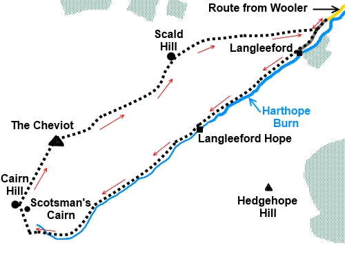
Start:
From the parking just before the bridge (NT 953225), cross the bridge and walk along
the tarmac farm drive. At
Langleeford Farm, the track splits, the left hand arm going to the farm.
Keep straight ahead through the walkers’ gate marked with a yellow arrow.
%20View%20along%20Harthope%20valley.jpg)
Ignore a path to the right signposted for
Scald Hill and The Cheviot and continue to follow the path alongside
Harthope Burn. This instruction is all you need for the next 3 miles or so.
The Harthope Burn valley is very attractive and as you get higher, there are
good views east.
%20Harthope%20Burn.jpg)
%20View%20East%20from%20the%20end%20of%20Harthope%20Valley.jpg)
Continue to follow the Burn as it climbs. Do
not worry too much if you think you have lost the path at any point. The
path can be obscured by bracken in the summer. Head
initially for the ‘V’ shaped notch at the head of the valley,then as
Burn/path eventually bend right (west), head for the fence visible on the
skyline ahead.
%20View%20south%20towards%20Simonside%20Hills.jpg)
You should reach the fence at a stile (NT
905190) (which you do not cross) but It does not matter too much at which
point you reach the fence as once you reach it, simply turn right to follow
it to the higher ridge. This is the steepest part of the climb which earns
it the red traffic light.
%20Hedgehope%20Hill.jpg)
You arrive at Cairn Hill on the wide ridge,
by Scotsman’s Cairn (more like a circular shelter). Cross the stile ahead
to join the paved path which is part of the Pennine Way and turn right (NT
903195). A finger post confirms The Cheviot summit is ¾ mile.
%20Cairn%20Hill.jpg)
%20En%20route%20for%20The%20Cheviot.jpg)
%20The%20Cheviots%20ugly%20trig%20point.jpg)
Follow the paved path to the trig. point (NT
909205) and beyond. You cannot really go wrong here unless snow is obscuring
the paving – in which case the route is 32° magnetic from the cairn and
69° magnetic from the trig. point.
%20The%20wide%20dome%20of%20The%20Cheviot.jpg)
When you come to a ladder stile, cross it and
begin your descent to Scald Hill, following the fence on your left. You will
notice some quite large cairns on the other side of the fence which might
make you think you are on the wrong side. However, the route is to the right
of the fence as will become obvious further down.
%20Stile%20to%20Scald%20Hill.jpg)
When a fence crosses your path, go over the
stile and continue to follow the fence on the left. Do not turn right along
the grassy track.
Keep following the fence until it turns left.
There is a gate at the corner. Turn right here, indicated by a post stuck in
the peat (NT 933221). In practice, the path actually forks right a few yards
before this.
%20Looking%20Back%20at%20The%20Cheviot.jpg)
The route now descends past a series of
grouse buts on the right. The footpath proper is actually a few yards to the
left but the path/track by the butts is less boggy! They join up anyway just
before a stile. Cross this and keep straight ahead on the obvious track.
When you reach the corner of a wood, go down
its left hand side and at the road, turn left back to the parking.
%20Housey%20Crags.jpg)
All information on this
site is given in good faith and no liability is accepted in respect of any
damage, loss or injury which might result from acting on it.
|


.jpg)
.jpg)
.jpg)