|
Caer
Caradoc Walk
Starting point and OS Grid reference:

Cardington
Village – On street or village hall parking (SO 506952)
|
Ordnance Survey Map
OS
Explorer 217 The Long Mynd and Wenlock Edge.
Buy this map from
List
of OS Maps
.Note: If you use OS Maps on-line, you can download this route via this
link.
| |
Distance: 6 miles
|
Date of Walk: 20 May 2013
| |
Ascent:
Descent:
See Walking Time Calculator
|
510m (1675ft)
516m (1693ft)
| |
Traffic
light rating: 

(For explanation see My
Walks page)
| |


For advice on .gpx files see
My Walks page
|

Click
the PDF logo above to give a printable version of this walk without the
photos.
|
To
view route as a dynamic Ordnance Survey map click here.
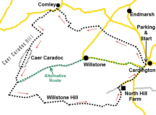
Introduction:
Caer Caradoc is a distinctive hill of volcanic rock 1500 ft (459 m) high
overlooking the Shropshire town of Church Stretton. It offers panoramic
views which include The Wrekin, Long Mynd and
Wenlock Edge and on a clear
day as far as the hills in North Wales and the Brecon Beacons.
On Caer Caradoc summit are the remains of an
ancient Bronze or Iron Age hill fort and, unlike at many such sites, the
remnants of the defensive ditches can easily be see.
This Caer Caradoc walk is a circular route
which starts and finishes at the pretty village of Cardington and takes in a
pleasant countryside walk before the ascent and incorporates a ridge walk
along Willstone Hill on the return.
To get to Cardington, turn north off the
B4371 at Wall Under Heywood, about 4 miles east of Church Stretton. Please
note the approach roads are very narrow with passing places. Parking in
Cardington is limited. Best options are probably the large village hall car
park opposite the main church entrance or the car park for the Royal Oak pub
but please get permission if using the pub car park and have the courtesy to
patronise the pub afterwards (I can vouch for the quality of the food and
beer – as at May 2013!).
There is a small amount of road/lane walking
but traffic is virtually non-existent. Overall, the walk is straightforward
but the climb up Caer Caradoc itself is steep and there is a moderate climb
up Willstone Hill.
Start:
Finding the start is almost the hardest part of the walk! From the main
entrance to the church, walk clockwise on the road, round the church
grounds, until you reach the back gate. Opposite is a cul-de-sac lane with
an unusual “Sat Nav Error” sign
(SO 506952). On the power pole is an orange arrow sign for the
Cardington Walk and these indicate your way for the first section of the
walk. Proceed along this lane and at the entrance to the Old Vicarage, turn
right.
%20Walk%20starts%20here.jpg)
%20Cardington%20Walk%20Sign.jpg)
As the track bends left, go straight ahead
across the field and through the gate at the end, following the right hand
right hand boundary of the next field and the following field. The
Cardington Walk arrows guide your path.
At the end of this second field, ignore the
yellow arrow indicating a path to the right and continue in the next field
following the right hand boundary.
At the top of this field, cross the stile in
the top right hand corner and go left to follow the left hand boundary of
this and the next field. At the road (SO 495960), cross straight over and
follow the wide track, leaving the Cardington Walk arrows behind.
After going through a gate, the track becomes
more grassy and curves left. There are good views along here, on the right,
towards the valley and the hill "The Lawley” and of course Caer
Caradoc to the left.
%20View%20NE%20from%20Folly%20Bank.jpg)
%20Caer%20Caradoc.jpg)
Stay on this track until it terminates at a
gate. Ahead is a bungalow and you need to aim across the field to its left
where, between it and the stone built house, you will find a stile in the
hedge, leading on to another wide track (SO 487961). Turn right on this
track, then left at a ‘T’ junction of tracks.
At the road (SO 485965), turn left, shortly
passing the site of Comley Quarry. This rather unprepossessing site is owned
by the Shropshire Wildlife Trust , where fossils of the first creatures with
shells were found in the 1880s. Rocks here are used as a reference for rocks
found all over the world.
As the road starts to descend, take the
footpath off to the left indicated by a finger post.
(SO 483965) It does say “Caer Caradoc 0.1 mile. 2 mins”, but you
will need to look at its reverse face as you approach.
Go through a gate with a small information
board and ignore the path climbing to the left. Stay on the broad track
until you reach a stile on the right, just before a gate (SO
479961). Take the steeply climbing path on the left to the col. Pausing for
breath (you will probably need to!), cross the stile on the right (SO
481959) and take the path to the summit.
%20View%20from%20the%20Col.jpg)
Here you can clearly see the remains of the
defensive ditches and there are some rocks which provide shelter from the
prevailing winds for a picnic lunch. There are good views SW over Church
Stretton to the Long
Mynd, NE and over The Lawley (hill) to The Wrekin and
more.
%20Top%20of%20Caer%20Caradoc.jpg)
%20Looking%20Down%20at%20Church%20Stretton.jpg)
Continue along the summit and as you start to
descend, you will see a broad grassy path bearing off to the right, towards
Church Stretton. Ignore this and keep more to the left of the ridge, where
you will soon come across a clear narrow path descending to a broad track in
the valley bottom, through a metal kissing gate.
%20Rock%20Formation%20on%20Caer%20Caradoc.jpg)
At the track (SO 475948), there is the option
to turn left for an easy walk back to Cardington. To continue on my route
and get the advantage of more good views, turn right instead.
As it descends, look out for another track
after about a quarter of a mile (SO 473944), almost doubling back on itself, heading into the trees.
Follow this for a short distance before bearing right to follow the course
of the stream, along its left hand bank. The path along here is not very
clear in places. Just let the stream be your guide.
The next turn is easy to miss but just short
of a quarter of a mile from the broad track, the stream splits (SO 477944).
Here, you should see across the stream an old, small, metal gate. It is past
the point where it can be opened but you can step over the old fence next to
it.
Once over the gate/fence, you are on an
obviously little walked route. Best advice is to aim for a mid-point between
the hills (75° magnetic if you want to check with a compass). On meeting a
clear broad path, turn left.
%20Looking%20Back%20at%20Caer%20Caradoc.jpg)
When you meet another track at a marker post,
just before a gate (SO 480945) turn right on a climbing path. At the stile
at the top, turn left, once again picking up arrows for the Cardington Walk.
Keep straight ahead, following the fence line on the right, ignoring the
paths off to left and right.
Follow the fence along the right. When it
bends right, keep straight ahead descending to a kissing gate. Turn left
following the orange arrow, heading for the brow of the small kill ahead.
Keep on the obvious path, arriving at North Hill Farm. Follow the concrete
drive, then tarmac road, downhill. At the road junction, turn left back to
Cardington.
If you need to buy any
hiking equipment/clothing before your trip see the Hiking
Store
All information on this
site is given in good faith and no liability is accepted in respect of any
damage, loss or injury which might result from acting on it.
|


.jpg)
.jpg)
.jpg)