
|
|
|
The ridge gives super views from along its length, not least across to the Long Mynd to the South East and Snowdonia to the North West. The largest tor is the Devil’s Chair, complete with an obligatory legend whereby the Devil was supposedly carrying stones in his apron when a string broke causing him to drop them. There is an unusual “window” in the Devils Chair through which, if you climb up, gives a good view across to the Long Mynd. On Midsummer’s Eve, the Devil evidently returns to sit on the chair and call on his followers to turn up and choose their king – but wouldn’t that be him? I doubt he would sit there for long! It is a bit lumpy! The Stiperstones Ridge was at one time an important area for lead mining, as evidenced by Snailbeach, with its Lead Mine, from where I started the walk. At its peak, it employed over 500 people. It closed in 1911 although some smaller scale mining for barites (used in paint and paper manufacture) continued until 1955. There is much industrial archaeology remaining and the site operates as a heritage centre. Unfortunately, it was closed at the time of my visit. Towards the end of the walk, the routes passes through the attractive village of Stiperstones, where the Stiperstones Inn offers a refreshment opportunity – well it would be rude not to!
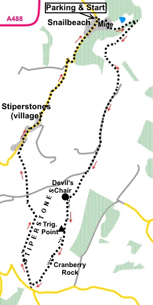
The walk begins at Snailbeach where there is an honesty box car park and public toilets. Please support with a donation to keep these facilities going. To get to Snailbeach, turn East off the A488, between Bishop’s Castle and Minsterley. Inclines on the walk are easy, apart from a very short steep section out of Stiperstones Village. There is a small amount of road walking but the roads are very quiet. Start: From the car park at Snailbeach (SJ 373023), cross the road and head up the cul-de-sac, signposted for Lordshill. You follow this tarmac lane for just over half a mile to Lordshill Farm. The lane climbs quite steeply. You quickly arrive at Snailbeach lead mine.
As the lane climbs further, views to the North, through the trees, start to open up. Follow the lane for almost to Lordshill Farm. Just before entering the farmyard, turn right over a stile and follow the footpath, as it curves anti-clockwise round the farm. The route is marked with yellow arrows and as you come round the farm, you will see one on a post ahead of you, by a stile. Cross the stile and turn right along a broad track (SJ 378020).
Follow the track to a gateway. Cross the stile next to it and in the field beyond, follow the left hand boundary. In the left hand corner at the end of the field, turn left through a kissing gate, following the yellow arrow direction. Head for the left hand corner of this next field and go through a kissing gate to pass a sign for the Stiperstones Natural Nature Reserve. At the head of a pretty valley, the path forks. The most direct route to the Stiperstones would be to fork right into the valley but this will mean a steep descent and ascent. As I prefer not to descend, only to have to climb up again, I opted for the marginally longer route and took the left direction, following the left hand field boundary.
Follow this path, through a patch of gorse bushes to a farm gate, and once again, stick with the left hand boundary to another gate at the top of the field, joining a sunken lane. Beyond this gate, follow the clear, broad track as it follows open moorland (SJ 377010).
Pass and ignore a more level green track going off to the right. The rugged outline of the Stiperstones starts to appear and to the left, in the distance, the Long Mynd.
Arrive at a large cairn, where blue arrows show bridleways in all directions (SO 373999). The main track you have been following curves left but you leave it at the cairn to go straight ahead on a greener path, towards the Stiperstones.
Meet another cross-roads of tracks at SO 371996 and go straight across. You arrive at the main outcrop of the Stiperstones, the Devil’s Chair. You can climb to the top by taking the logical route up the more gentle slope to the right. There is a dramatic view through a stone arch but you need to take great care, as there is potential to come a cropper!
Whether you cross the Devil’s Chair or stay on the main path along the front of it, follow the obvious path along the ridge, passing Manstone Rock where the trig. point sits (SO 367986). This path is very rocky underfoot and you need to watch where you put your feet.
At SO 368988, pass an ancient cairn, a huge pile of stones.
Continue following the path as it descends slowly, passing a prominent upright rock. At SO 367983, arrive at a large cairn. Branch right here to Cranberry Rock.
At the next group of rocks SO 366981, keep on the path to the left initially. About half way along the line of rocks, the path crosses to the other side (SO 645980), then turn left. At SO 364778, join another footpath and turn right. At SO 362977, join a bridleway by a Stiperstones Natural Nature Reserve and turn right following a blue bridleway arrow. At SO 361982, pass and ignore a footpath off to the left. Cross a broad track and keep straight ahead (SO 361992). After two or three hundred yards, as you get to another Stiperstones Natural Nature Reserve sign, turn left through a gate, following a blue bridleway arrow (SO 341994). Immediately through the gate, head for the far right hand corner of the field and cross a stile. Beyond this, aim to the left of the farm you can see in the valley below. After a short distance, the route becomes obvious. Follow the path down through the trees. Cross a stile, then swing right to follow the left hand boundary of the field. The village of Stiperstones is ahead, in a beautiful setting.
The field narrows to a point and at the point, cross a stile to join the road. The stile is not visible until you get to it. Pass the Stiperstones Inn and on the bend of the road (SJ 363004), turn right, keeping to the left of the telephone box and follow the tarmac drive as it climbs. It changes to a rougher stone track. Cross a stile where there are two yellow footpath arrows, then turn immediately left up the steep bank. After the short steep section, the path levels out. Keep to the path, which follows the fence on the left. Good views over the Hope Valley.
The path emerges in the drive to some cottages (SJ 369015). Turn right to the road then right along the quiet road back to Snailbeach. If you need to buy any hiking equipment/clothing before your trip see the Hiking Store All information on this site is given in good faith and no liability is accepted in respect of any damage, loss or injury which might result from acting on it.
| | |||||||||||||||||

.jpg)
.jpg)
.jpg)
 Introduction: The
Stiperstones walk takes you along the famous Stiperstones ridge, which is
part of the Shropshire Way. At its centre are the rocky jagged tors of The
Stiperstones themselves, quartzite outcrops from what some 500 million years
ago, would have been a marine area. They are a distinctive landmark rising
to 536 metres visible for miles around.
Introduction: The
Stiperstones walk takes you along the famous Stiperstones ridge, which is
part of the Shropshire Way. At its centre are the rocky jagged tors of The
Stiperstones themselves, quartzite outcrops from what some 500 million years
ago, would have been a marine area. They are a distinctive landmark rising
to 536 metres visible for miles around.
%20Mine%20buildins%20at%20Snailbeach%20Mine.jpg)
%20Winding%20gear%20at%20Snailbeach%20Mine.jpg)
%20View%20NE%20near%20Lordshill%20Farm.jpg)
%20Pretty%20valley%20referred%20to%20in%20text.jpg)
%20View%20west.jpg)
%20Stiperstones%20Village.jpg)
%20First%20sight%20of%20the%20Stiperstones.jpg)
%20After%20turning%20off%20at%20SO%20073999.jpg)
%20Approaching%20the%20Devil's%20Chair.jpg)
%20Window%20on%20Devils%20Chair.jpg)
%20Looking%20through%20the%20window.jpg)
%20View%20to%20the%20Wreakin.jpg)
%20Prominent%20Rock%20at%20Manstone%20Rock.jpg)
%20Manstone%20Rock%20with%20Trig%20Point.jpg)
%20Ancient%20cairn%20with%20Devils%20Chair%20behind.jpg)
%20Cranberry%20Rocks.jpg)
%20Beautiful%20setting%20of%20Stiperstones%20village.jpg)
%20View%20over%20the%20Hope%20Valley.jpg)