
|
|
|
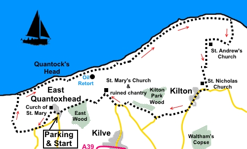
To view route as a dynamic Ordnance Survey map click here. Introduction: This easy walk from East Quantoxhead is an interesting mix of coastal footpath walking, countryside and interesting churches. Along the way is all that remains of the Somerset Oil Boom (that never was!), a good view of the Bristol Channel and the Wales coast. Not to be missed amongst the churches is St. Andrew’s Church at Lilstock and a ruined chantry not far from Kilve. Please note when walking on the coast path that the cliffs in these parts are very crumbly, so do not walk too close to the edge or sit on the beach immediately below them. Having said that, one advantage is that the cliffs are made of layers of shale embedded with fossils. Their ongoing collapse means loose fossils can be found on the beach, if you are inclined to search. This same shale is oil-bearing, hence the establishment of the Shaline Company in 1924 to exploit the resource. A retort house was established to convert the shale to oil. However, unable to raise the necessary finance, the anticipated oil bonanza never happened and all that remains is a rather ugly but interesting brick built oil retort. Far from ugly are the churches you pass on the walk. One in particular has to be picked out, namely St. Andrew’s Church, small and cute (if that is an apt description for a church), with only two rows of pews and only one service a year according to a notice board. Do not miss this. It is recorded in the Domesday Book in 1086 but there had been a church here for years before. The present church was built on the same site in 1532. After a mixed history, by 1554, it was described as “greatly ruined”. However in the 19th Century, services were being held every Sunday. Sadly, by the late 1800s, it was in ruins again and the nave was levelled. In 1980, it was declared redundant and deconsecrated. To cut a long story short, the church was restored by 1993 and is now under the ownership of a charitable trust. The church publishes a pamphlet with far more information. Near Kilve on the return leg, there is a ruined chantry. The remains are only standing thanks to extensive steelwork but there is a lovely café alongside. The walk starts from a large car park, by the duck pond in East Quantoxhead.. To get there, turn right off the A39 just west of Kilve. Start: From the car park, take the path from the rear corner, closest to the church – The Parish Church of St Mary the Virgin, which is worth a look.
Go through a kissing gate just before the church and turn left. Go through a metal gate and head for the diagonally opposite corner of the field where you meet a road. Turn right along the road for not much more than two hundred yards. At the bend, branch off right along a broad bridleway. There is a yellow arrow pointing the way. After about a third of a mile look out for a three way fingerpost on the left. Turn right here following the yellow arrow. Follow the right hand boundary of each field which follows until you join the West Somerset coast path. Turn right following the fingerpost for “Kilve two miles”.
Across the Bristol Channel, on a clear day (which I was not blessed with), you can see the south coast of Wales and should be able to pick out the islands of Flay Holm and Steep Holm. In the distance is the mass of the Hinkley nuclear power station but a better view of this follows later. There are some dramatic patterns in the shingle created by the tides.
At ST 137443 the path diverts inland indicated by a fingerpost for “English Coast Path” and “Kilve ½ miles”. This is a little misleading as it is only for a few yards, after which it turns left by steps down to the beach, to rejoin the cliff edge, confirmed by another coast path fingerpost. At ST 142443 is a large open area where there are a number of benches which make for a pleasant picnic spot. At the far side of which is the curious brick structure of the oil retort house. The path curves anti-clockwise round it.
Continue to follow the coast path. It eventually becomes part of a broader farm track between cultivated crops and the cliff edge.
Continuing along this brings you to what looks like a coastguard station but is actually a Royal Navy aircraft range observation post (ST 161453).
Keep following the coast path. At ST 168455, you reach a section of cliff which has been reinforced with large boulders. There is also an information board about this patch of coast. Evidently there was a harbour here at one time. Go through the kissing gate and follow the rocky path beyond. Just after passing an old pill box and the Lilstock Outfall, turn right to follow the finger post for “Stolford 6 miles”. Within a few yards is a post marked with a yellow footpath sign and one for the coast path (acorn) off to the left. Ignore this and stay on the obvious main track, which emerges into the car park via a metal gate. Follow the access track out of the car park. On joining the tarmac road, turn right (ST 171449). Follow the road until just after a sharp, left hand bend, you pass the entrance, on the left, to St. Andrew’s Church. (ST 166449) It is easy to miss this gem of a church as the entrance looks, at first glance, like the entrance to a private house and there is no roadside sign. It is well worth a few minutes to see this.
After St. Andrew’s Church, continue along the road, keeping straight ahead at the next junction, to the village of Kilton. On the outskirts, turn right to see St Nicholas Church (ST 166441), then return to follow the road as it bends right, ignoring the left turn.
Pass Kilton Farm West as you leave the hamlet and just as you reach the second farm on the left after that, turn right through a metal gate. There is a yellow arrow on the left gatepost, indicating the correct direction to another metal gate which you can see. In the two fields beyond it, follow the left hand boundaries, dropping down to Lower Hill Farm. Cross the stream and turn right along its drive, then through a walkers’ gate on the corner. Follow the right hand boundary to another walkers’ gate. The footpath then follows the edge of the woods. At the end of the woods, go through a metal gate and follow the path round to the left following a yellow arrow, along a wide, hedged track. At the road, turn right, then, at the ‘T’ junction, turn right. You arrive at the Parish Church of St. Mary the Virgin (your second St. Marys of the day!), unusual in being rendered. The route continues from the rear of the churchyard but before continuing, walk a short distance down the road to see the ruined chantry.
Returning to the churchyard, walk along its path and through the gate at the back. Turn left to follow the yellow arrow on a fingerpost. Arrive at a junction of paths where there is a fingerpost amongst the trees. Keep straight ahead following the fingerpost for East Quantoxhead. The obvious path takes you back to the duck pond and car park where you started. If you need to buy any hiking equipment/clothing before your trip see the Hiking Store All information on this site is given in good faith and no liability is accepted in respect of any damage, loss or injury which might result from acting on it.
| | |||||||||||||||||

.jpg)
.jpg)
.jpg)
%20Duckpond%20at%20East%20Quantoxhead.jpg)
%20Parish%20church%20of%20St%20Mary%20the%20Virgin.jpg)
%20Coastal%20View%20West%20towards%20Minehead.jpg)
%20Tidal%20patterns%20in%20Bridgewater%20Bay.jpg)
%20Remnant%20of%20the%20Somerset%20oil%20boom.jpg)
%20Coastal%20scene.jpg)
%20Telephoto%20shot%20of%20Hinkley%20Power%20Station.jpg)
%20Royal%20Navy%20aircraft%20observation%20post.jpg)
%20St%20Andrews%20Church.jpg)
%20St%20Nicholas%20Church.jpg)
%20Parish%20church%20of%20st%20mary%20the%20virgin.jpg)
%20Chantry%20Ruins.jpg)