
|
|
|
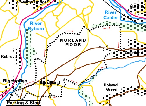
To view route as a dynamic Ordnance Survey map click here. Introduction: There is a bit of allsorts on this walk from Ripponden. Part of it crosses Norland Moor from where there are great views, there are field, woodland paths and streams and a close look at the historic Barkisland hall. The route utilises some of the Calderdale Way. Ripponden sits by the River Ryburn, a tributary for the River Calder and is not far from Halifax. It evidently has evidence to prove that the first Co-op was opened there in 1832 which predates Rochdale’s claim to have had the first in 1844. Originally, Ripponden was a farming community but morphed into a cotton and wool producing area. The damp Pennine atmosphere was conducive to cotton working. The river provided power. On the walk, various mill buildings are passed, mostly now converted to apartments. Another claim to fame is as host to the annual Pork Pie Appreciation Society! Norland Moor, a gritstone plateau, is popular heather moorland, is crossed by many footpaths. It rises to 932 ft (284m). There is a trig. point at the summit, which this walk visits. There is evidence of quarrying and ancient use. Standing stones, ditches and banks have been found. There are views over Halifax and Sowerby Bridge. The famous Wainhouse Tower in Halifax, originally intended as a chimney but converted to a ‘folly’ following objections, is clearly visible. Barkisland hall is a magnificent building. Built in 1638, originally for the Gledhill family. It is Grade I listed. It is not open to the public. There is some ‘up and down’ on this walk but I begin the traffic light rating with an amber indicator, simply because of the very steep rise from the start. After that, everything else pales. There is also some road walking. The walk starts from the free, public car park, off Mill Fold. To get there, turn left off the A58 at Ripponden, about three and a half miles from Halifax. Start: Exit the car park to the road. Turn left very briefly then right to St Bartholomew’s Church at Bridge End. Turn right at the church and follow the road as it curves left. You now embark on what is probably the steepest part of the walk out of the valley, along this partially cobbled road (Ripponden Old Bank).
At
the road junction at the top, turn left along the B6113. Pass the Fleece pub and at the next road junction, turn left off the B6113 on to a broad track marked by a fingerpost for “Calderdale Way”. You go through a gateway to follow a walled path. When it opens into a field, follow the left hand boundary. At the end of the field, go through a stile and turn right.
Follow
the path as it climbs the hill, ignoring a path off to the left signposted
for “Longley”. Arrive
at the drive to a house and turn left along it. At the road, turn left (SE
069220), soon passing a caravan site. About
a hundred yards after the caravan site, turn right on to the Calderdale Way
and “Clough Bridge”. Continue to some distinctive rocks at SE 054214 and turn right to the trig. point.
Turn left at the trig point (as you approached) and on meeting the Calderdale Way path again, turn right.
At
a crossroad of paths, keep straight ahead. At
SE 060219, ignore a path off to the left, to stay on the Calderdale Way. A
few yards further on, the path splits. Just by some iron railings. Turn
right here (SE 060220). Come
to a major cross roads of paths (SE 064219). Keep straight ahead. Arrive at a ‘T’ junction of paths by a very ‘neat’ conical cairn (SE 066219). Turn left.
At the next crossroads of paths, turn right across a stream and immediately afterwards, take the right fork (SE 068222). Join
the road by the sign “Welcome to Norland”. Turn right and follow the
road as it turns left. Ignore
the first footpath on the left. Shortly after that turn left on a wide track
by some impressive gates. There was the post for a sign here but at the time
of my visit, the ‘finger’ was missing. Follow
this track and the left hand boundary of the field beyond. At
the end of the field, cross a stile and follow the obvious path through the
woods. Emerge
from the woods to join another path by North Dean Wood farm and turn right
to follow the access track. At a crossroads of tracks (SE 082220), keep
straight ahead on Moor Bottom Lane and follow it for around half a mile to
join the B6113. There is a bench on the corner here should you wish a stop. Cross
straight over the B6113 and down Brian Royd Lane. As it bends quite sharply
left, keep straight ahead on a track path with a fingerpost for “Kent
Lane”. When the path divides, keep left following a public footpath sigh
on a telegraph pole. Follow
the path past the cottages to the road (the B6114). Cross straight over and
follow the grassy track. At what is effectively the bottom of someone’s
lawn, turn left through a stile and follow the left hand boundary of the
field. At
the bottom of the field, go through another stile and turn right. On joining a tarmac lane, turn right and just before the lane crosses the stream, turn right down some stone steps and follow the path ahead, keeping the stream on your left.
On
reaching some mill buildings, go between them to the road and turn left (SE
068202). Stay on the road for just under a quarter of a mile until just after a large stone built house on the right, go through a gate to its left, indicated by a fingerpost for “Sandyfoot” and “Clough”. Follow the right hand boundary of the field and the stream.
After
almost half a mile, at the end of a long field on the left, turn left over a
stile. The point can be confirmed by noting a large rectangular slab of
stone not quite bridging the stream below (SE 061202). The
path goes straight up the field, alongside a dilapidated stone wall on the
right. At the top of the field, keep to the left of a brick built building
and go through two gates to join a walled track. This will bring you out at Barkisland Hall (SE 060200). Emerge at the road and turn right for only a few yards before taking a footpath on the left signposted for “Steel Lane”, immediately past the old stocks.
At
the bottom of the field, cross the stream and up the steep hill beyond,
where the path bears left and curves clockwise. It
opens into a field. Follow the dilapidated wall on the left. At the top of
the field go over a stile and turn right along the broad track. It becomes
tarmac. Stay on it to the road and turn left. Take
the footpath on the right opposite a bus stop. It is marked by a fingerpost. Cross
two fields and in the second, make for the far right hand corner, where
there is a stile. Over this, follow the right hand boundary to the road. Go
straight over the road (slightly left) and over another stile. Bear left
towards the farm buildings and at the far side of the field, go through a
gate on to the road. Cross and go down Fiddle Lane. After a quarter of a mile, just before Fiddle Kane bends right, take a bridleway on the left (SE 047197), heading towards Ripponden which you can see. Note that when I did this walk, there is a cobbled section of this bridleway over which water was flowing after heavy rain. This made the cobbles slippery.
On
reaching a tarmac lane, turn left and right at the road. At
the next junction turn left to return to the parking. If you need to buy any hiking equipment/clothing before your trip see the Hiking Store All information on this site is given in good faith and no liability is accepted in respect of any damage, loss or injury which might result from acting on it.
| | |||||||||||||||||

.jpg)
.jpg)
.jpg)
%20Ripponden%20with%20St%20Bartholomews%20Church.jpg)
%20Spring%20and%20trough%20on%20Ripponden%20Old%20Bank.jpg)
%20Ripponden%20from%20Ripponden%20Old%20Bank.jpg)
%20Looking%20towards%20Sowerby%20Bridge.jpg)
%20Another%20view%20over%20Riponden.jpg)
%20Rocky%20outcrop%20at%20SE%20054214.jpg)
%20Trig%20point%20on%20Norland%20Moor.jpg)
%20View%20from%20quarry%20on%20Norland%20Moor.jpg)
%20Neat%20cairn.jpg)
%20stream%20near%20Greetland.jpg)
%20View%20towards%20Halifax.jpg)
%20Barkisland%20Hall.jpg)
%20Stocks%20at%20Barkisland.jpg)
%20Bridleway%20back%20to%20Ripponden.jpg)