
|
|
|
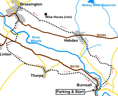
To view route as a dynamic Ordnance Survey map click here. Introduction: This circular walk from Burnsall to Grassington is an alternative to (and borrows sections from) my Burnsall to Grassington walk which sets out along the River Wharfe and my Grassington to Appletreewick walk via Thorpe. The big difference is that this walk does not use the riverside path at all, which has the advantage of keeping you away from the multitudes that walk this section. It takes you on a higher level way above the river through the sleepy village of Hebden. The village grew through lead mining in the area but since this ceased, it has reverted to a quiet rural place with a large contingent of second homes. It has a tea-room and a pub and is popular with walkers because of the large number of routes which can be walked from there (see also my Hebden to Grassington via the Mines and Hebden to Grassington via Yarnbury Henge walks for example). En route to Hebden you pass a trout farm. The walk passes through the very popular and pretty village of Grassington. Although it has much of the frippery of all tourist villages, it is a real place where you can buy a bag of spuds or joint of beef as easily as postcards. From Grassington, the route descends to the dramatic Linton Falls and weir, before climbing to the secluded hamlet of Thorpe with its pretty manor house and back to Burnsall. There are good views of the Wharfe valley on most of this route. The going is easy overall but there is a steep section just after the start, hence the amber traffic light. Refreshments can be obtained at Hebden and of course Grassington (I have a penchant for the Foresters Arms). On return to Burnsall, there is the Red Lion, if you can afford it! Start the walk in the Dales village of Burnsall. There is a car park although on quiet days, it is possible to park on the main street by the river where there are benches to sit and feed the ducks or put on boots. #
Note the observant among you will spot that all the pictures do not all look
appropriate to the date of the walk. This is because the day in question was
a very grey day with low cloud/mist. I did not therefore take a camera but
have borrowed appropriate pictures from other times I have walked in the
area. Start: Turn right out of the car park (SE 032612) and right at the junction to cross the river bridge. Immediately after crossing the bridge, turn left through a slit stile to descend the steps, following the fingerpost for “Scuff Road”.
Cross a stone stile and follow the river as far as a ladder stile. Cross this then fork right to climb the hill. At the road, go straight across and over a gated stile to follow the fingerpost for “Hartlington and Raikes Road ½ mile”. You will note some irregular depressions in the field. Keep to the right of these to another stone step stile. The next stile along the route is then visible – i.e. the one straight ahead, not the one in the corner. Follow the footpath as it bears left. Cross a gated step stile and head for another straight ahead. As you head towards the farm, look out for another gated stile and fingerpost next to a gate (SE 037621) – not the one nearest the farm. Cross this stile and turn sharp left to follow the fence. At the wall, cross another stone step stile and turn right to follow the public footpath fingerpost. This takes you to yet another gated step stile. Cross this and turn left once again following the public footpath fingerpost. Bear off slightly right to about half way along the far side of the field. The village ahead is Hebden and if you head for that, you will be on course. There are good views along the valley from here. Keep well to the left of a stone barn and as you crest the rise, you will see a farm gate below. Go through the gate and head to the farm. Go through the farmyard, to the left of the farmhouse and through the gate (SE 030624). There was a faded yellow “blob” on the right gatepost when I passed. Go through a gate in the opposite corner of the field, then follow the broad track, descending to link up with another and following a fingerpost for “Hebden”. At the junction, go straight ahead to follow the obvious footpath, the first part of which is paved with stone slabs. Here you pass the trout farm. You cross a footbridge (SE 029628), then keep to the obvious route following the left bank of the stream initially then climbing to the Hebden Main Street. Turn right along this then at the main road (B6265) turn left. Pass the Clarendon Hotel and a bus depot. Immediately after the depot is a broad track. Ignore this and take a walled footpath on the right shortly after, following the fingerpost for “Grassington via High Lane” (SE 024632). The route is now obvious, more or less in a straight line and indicated by a series of stiles. At a copse of trees, where there is a fingerpost indicating “Grassington”, go straight through the trees. There is an information board for “Grassington Park Estate Meadows”. In the rough field beyond, the footpath is paved with stone flags.
Go through a gap in a hedge, where the path divides. Ignore the left branch and keep straight ahead. Cross a tarmac drive and continue in the same direction beyond. Keep a look out for the ruin of Wise House farmhouse a little way off on the right. As you draw level with this, join a broad track and follow this to the gate. Go through and follow the right hand boundary. At the next corner, bear slightly right following the public footpath fingerpost to the corner opposite.
At the corner is a public footpath fingerpost. Continue straight ahead and along a walled lane (High Lane) which leads you into Grassington. At the junction, turn right then left to walk down Grassington Main Street (SE 003642). Plenty of choices for refreshment!
At the bottom of Main Street, turn left to the large car park and Yorkshire Dales National Park Information Centre.
With your back to the Yorkshire Dales National Park centre in the car park (SE 003638), walk across the car park, bearing left, until you come to the footpath going right, down to Linton Falls. Cross the falls by the bridge and turn right then left at the old packhorse bridge (do not cross it). On reaching the road turn left.
If you want to visit Linton Church, this can be visited by following this road for a few hundred yards to its end. Otherwise, after passing the car park and public toilets, watch out for a footpath on the right (SE 003632) indicated by a sign on the side of a house stating "B6161 via Stickhaw ½ mile" and "Linton Camp ¼ mile". Note, this is easy to miss! After 50 yards, turn right by the sign “Linton via B6160”. On reaching the road, turn right and at the fork, go left. About 300 yards from the junction, take the footpath on the left indicated by a fingerpost for “Thorpe Lane ½ mile”, “Threapland 2¾ miles” and “B6160” (SD 999629). The path goes straight through the farmyard and enters a large field. Head for a spot about half way along the opposite wall and join a broad track through a walkers’ gate. Turn left. You pass a fingerpost for Threapland but do not go in that direction. You soon pass another fingerpost pointing in your direction of travel to Thorpe. Pass and ignore a track on the left which just goes into a field. At the top of a slope, enter a large field and follow the left hand boundary to a gate next to which is a gated stile. Through this, head towards the left hand side of the trees straight ahead.
Pass the trees and follow the right hand field boundary to the top right hand corner of the field, go over a gated stile and turn left on Thorpe Lane (SE 005621). You arrive at a ‘T’ junction (SE 013620). Turn right into the hamlet of Thorpe. Turn left at the fork in the road (SE 013618) and climb the hill out of the hamlet. As it bends sharp left (SE 015619), take the track on the right signposted “Burnsall 1¼ miles”.
It starts off as a stony track then turns grassy. Follow the track to a walkers' gate, go through it and follow the well marked path downhill, a few yards right of the trees. At the end of the trees, follow the wall and fence round to the left crossing a stream via a plank, after going through a gated slit stile. The path, which is easy to follow, then crosses a series of gated stiles and a couple of stone tracks before arriving in Burnsall. Turn right and follow the road round to the bridge over the river Wharfe.
If you need to buy any hiking equipment/clothing before your trip see the Hiking Store All information on this site is given in good faith and no liability is accepted in respect of any damage, loss or injury which might result from acting on it.
| | |||||||||||||||||

.jpg)
.jpg)
.jpg)
%20Burnsall%20Bridge.jpg)
%20Paved%20path%20across%20field.jpg)
%20Ruined%20Farmhouse.JPG)
%20View%20back%20along%20the%20valley.jpg)
%20Grassington%20Main%20Street.jpg)
%20Weir%20at%20Linton.jpg)
%20Linton%20Falls.jpg)
%20View%20over%20Grassington.jpg)
%20The%20manor%20house%20Thorpe.jpg)
%20Approaching%20Burnsall.jpg)
%20Burnsall.jpg)