|
Fremmington
Edge and Langthwaite
Starting point and OS Grid reference:

Reeth - parking on the village green (SE 038993)
|
Ordnance Survey Map
OL
30 Yorkshire dales – Northern and Central.
Buy
this map from
List
of OS Maps
Commission
from map sales is used to fund the website, so keeping it free to use.
| |
Distance: 8.7 miles
|
Date of Walk: 15 June 2011
| |
Ascent:
Descent:
See Walking Time Calculator
|
| |
Traffic
light rating: 

(For explanation see My
Walks page)
| |


For advice on .gpx files see
My Walks page
|

Click
the PDF logo above to give a printable version of this walk without the
photos.
|
To
view route as a dynamic Ordnance Survey map click here.
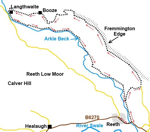
Introduction:
I
am sure that many people who go to Reeth to walk are probably thinking of
upper Swaledale, Gunnerside for their walking route etc but when I parked in
Reeth, I found myself looking up at the ridge towering above (Fremmington
Edge) and wondering what was up there. This walk was the result. It gives
good views of Reeth and Swaledale plus some of the ubiquitous mining remains
in that part of the world but also ventures into a little known Yorkshire
Dale of
Arkengarthdale whose main claim to fame is that the bridge in
Langthwaite featured in the opening credits of All Creatures Great and
Small, the 1970s TV series based on the books of the vet James Herriot.
This
walk starts in the centre of Reeth where there is parking on the village
green (SE 038993). Note, market day is on Friday when it will be much busier
with reduced parking. There are public toilets here. Reeth is the main town
in Swaledale on the B6270.
Firstly
it is important to note that the footpath route shown on the Ordnance Survey
map as crossing the river near Town End Hall at SE 040997 is impassable. The
route is marked with footpath arrows and a sign warns of a “difficult”
river crossing but this is a gross understatement. I believe there once was
a route across the dam but this has long since disappeared. I wasted time
trying this route so do not fall into the same trap.
Start:
To
get to Fremington Edge therefore begin by following the main road B6270
south east out of the village (that is downhill from the centre of Reeth
with the bus shelter on your left). Cross Arkle Beck by the road bridge and
just after the bend immediately afterwards, take the footpath on the left
indicated by a fingerpost, over a gated stile (SE 042992).
Follow
the wall on the left. Through a gate, head for the right hand side of a
stone barn. There is an orange arrow on the barn indicating the way. There
is a gated stile straight ahead.
%20Fremmington%20Edge.jpg)
In
the next field bear right and climb the small rise heading for the right
hand corner of the field where a finger post points the way. The route is
now clear and after a couple of stiles, there is another stone barn. Pass to
the left of this to the gated stile at the top of the field. There is a
three way finger post and you want the middle route straight ahead climbing
the hill (NZ 041001).
The
steeply climbing path meets a broad track. Turn left ignoring the strangely
directed old green footpath sign. Climb the broad track and where it forks,
keep left. You get to a fingerpost indicating Fremington Edge to the right
following the main track but there is a grassy track here to the left which
makes for a more comfortable route. There is a broad track and bridle way
shown on the OS map at Fremington Edge Top but the continuation of the
grassy track (NZ 044006) keeps you closer to the edge for the best views
back to Reeth and up Arkengarthdale.
%20reeth.jpg)
%20View%20East%20along%20Fremmington%20Edge.jpg)
%20Cairn.jpg)
Follow
this path until as the Edge starts to decline after almost 2 miles. There is
a large stone cairn (NZ 025024) where the path turns away from the Edge
amongst some old mining remains. Use the gash in the hillside opposite as
the direction to follow and you will quickly join the broad Fremington Edge
Top track (NZ 025025) which is marked at intervals with stone cairns. Turn
left and follow this track. It swings left heading downwards
for Arkengarthdale. It wends its way down below some old spoil heaps
and eventually turns left through a wall (NZ 020024) signposted “Langthwaite”.
At
a ‘T’ junction of tracks by a farm, turn right (NZ 018022). Follow the
concrete track slightly uphill from the farm and take the sharp right hand
turn sign posted Slei Gill (NZ 017021). Very shortly the path forks at a
fingerpost. Take the left fork. At the top of the field, go through the
right hand gate.
At
the farm, pass through two gates close together and you are in the hamlet of
Booze. I am assured this is pronounced Bose and is nothing to do with drink
but comes from either the Old English for house on the bend of the road or a
reference to “bousing”, a process connected with lead mining which was
prevalent in these parts. Turn left to climb the hill, passing Maple
Cottage.
%20Lamgthwaite%20Bridge.jpg)
%20Footpath%20through%20tunnel.jpg)
This
track becomes a tarmac road which takes you to the small village of
Langthwaite. The entry into the village on this route is particularly
picturesque. Refreshments can be obtained at the Red Lion pub.
With
your back to the pub, walk straight ahead and follow the path to the left
hand side of the beck. At all junctions now, keep right following the course
of Arkle Beck to Reeth but do not
cross it.
You pass under
an old bridge.
You
arrive at a stone barn in a field with an orange arrow pointing left. This
is where you join the same path on the outward journey. Keep right and
return to Reeth.
If
you need to buy any hiking equipment/clothing before your trip see the Hiking
Store
All information on this
site is given in good faith and no liability is accepted in respect of any
damage, loss or injury which might result from acting on it.
|


.jpg)
.jpg)
.jpg)