
|
|
|
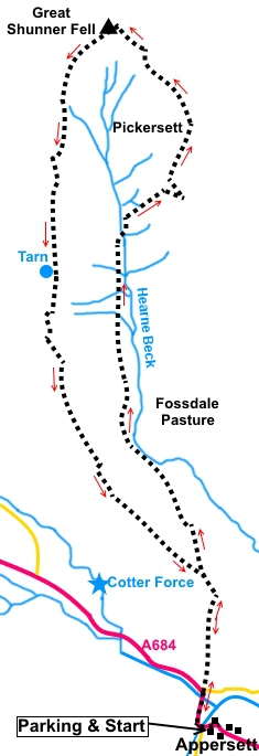
Introduction: Great Shunner Fell, between Swaledale and Wensleydale, is the highest point in Wensleydale at 2349 ft (716m) and the third highest in the Yorkshire Dales, being surpassed only by Whernside and Ingleborough. The Pennine Way passes over it. Both the rivers Swale and Ure begin life on its slopes and coal was mined in a few places until the 1880s. My route passes some old, black tips. The views from the summit are possibly the best in the Dales, although I did not pick a day of best visibility for my walk, as you can see from the photos. On a clear day, you will see Buckden Pike, Pen-y-ghent, Ingleborough and Whernside plus the Lake District hills and Howgills. There are also good views of Swaledale and Wensleydale. This Great Shunner Fell walk whilst not being particularly steep overall (with a couple of short exceptions) is not a particularly easy ascent because of the need to plough through long spiny grass along part of it. It was also quite boggy when I did the walk and I was grateful for my gaiters! The walk is also “off piste” for about a mile and a half, using the benefits of Access Land to create a circular route. In consequence, some of the route is not overly obvious on the ground. Having said that, there are rows of poles and grouse butts to help navigate. The GPS route I show is the route I actually took and whilst in parts it may not be the most direct, it seemed the best way at the time. Having said all that, I feel you should be fairly confident of your navigational abilities, especially if visibility is poor as the higher levels are relatively featureless. The descent is straightforward as it follows the well walked Pennine Way. There is a cross shaped shelter on the summit, with seating and a group of boulders on the ascent, either of which will provide a potential lunch stop. There is not much else. The walk starts from the small, rather plain hamlet of Appersett, which lies a mile west of Hawes on the A684. There is a large rough lay-by on the north side of the road in the hamlet, next to the village green, where the locals often hang washing (SD 859907).
To
view route as a dynamic Ordnance Start: From the parking spot (SD 859907), turn right along the road and cross Widdale Beck, a tributary to the River Ure, via the road bridge. Around three hundred yards further on, cross the river Ure itself via a second road bridge. Within a hundred yards of the second road bridge, meet a road junction and take the footpath through a walkers’ gate indicated by a fingerpost for “Bluebell Hill ½ mile”. Head for the far left hand corner of the field and through a walkers’ gate there. Cross the stream. The path then veers left.
At a three way fingerpost, all of which say “Footpath”, continue straight ahead, up the steep hill, passing to the left of a solitary rock. At the top of the hill, cross a ladder stile and continue straight ahead. Follow the wall on the right as it curves round to a gate. Through this, join a broad track and turn left (SD 859919).
After the next ladder stile (or use the gate), arrive at a three way fingerpost. The main track (now the Pennine Way) curves left but you branch off right (SD 858921), to follow the fingerpost for “Pickersett Nab 22/3 miles”. You are now following the Hearne Coal Road shown on the OS map. Just after crossing a stream, follow the main path as it bends left.
The path soon becomes indistinct in places, not least because it is obscured by the stiff coarse grass (I believe it is called Juncus) which is quite hard to progress through. There are 3 to 4ft tall bare poles at intervals which will guide you, as long as you can spot them amongst the tall grass! Essentially, you follow the course of the Hearne Beck valley. It is worth trying to locate the poles because they will guide you down to the point at which you cross the beck via a dilapidated gate at SD 850954. The gate is at the right hand end of a short length of wall, with fencing at either end. A good way to work out when you get there, apart from the poles, is to look out for an area of boulders which are close to the wall and which will provide somewhere to sit for lunch if you want it. Once
across the beck, climb the steep bank beyond. Walk parallel with the fence
line initially, for something like a hundred and fifty yards, then branch
off right up the steeper part of the hill. Before you have gone very far,
you will see what at first glance might be mistaken (hopefully?) for a seat
but in fact it is a grouse butt.
Make your way to the grouse butt and you will then see that it is the end one of a row. Follow the row along, passing some old tips, to arrive at a wide stony track (SD 856957). Turn left along it.
The stony track gives way to grass but the onward route was fairly clear on the ground with evidence of 4x4 traffic. Follow this as it curves to follow yet another line of grouse butts.
Look out for a dilapidated wall on the right. The route continues parallel to this. The summit of Great Shunner Fell is ahead and you will probably be able to make out the shelter on the top.
The last grouse butt is number 8 (you might have to look at the opposite side to see the number) is at SD 855967. The compass bearing from here is 311°, if you cannot see the summit. After the dilapidated wall ends, it is replaced with a fence. If you spot a stile over it, you can cross, then follow the fence, then to your left. I did not realise this at the time, there not being an “official footpath” here and I continued to the left of the fence until I reached a gate bearing a notice (the notice has to be read from the other side), at a corner of the fence. It was secured in such a way as to make opening it difficult but the fence is low enough to hop over. Follow the fence on your left towards the summit.
Arrive at a low stile. Cross, turn right and climb the few steps to the summit shelter. The trig. point is at the end of the nearest arm of the shelter, built into the wall.
The descent from the summit is clear, along the well trodden Pennine Way, at the opposite (south-west) end of the shelter to which you arrived. Much of it has been “manicured” with stone slabs etc as protection from erosion.
At SD 843950, pass to the left of a small tarn.
Around one and a quarter miles after the tarn, join a broad track at a three way fingerpost (SD 848932), and turn left to follow the sign for “Pennine Way”, “Public Bridleway” and “Hardraw 1¾ miles”.
You arrive at the three way fingerpost met on the outward journey. Turn right following the Pennine Way fingerpost and retrace your steps. If you need to buy any hiking equipment/clothing before your trip see the Hiking Store All information on this site is given in good faith and no liability is accepted in respect of any damage, loss or injury which might result from acting on it.
| | |||||||||||||||||

.jpg)
.jpg)
.jpg)
%20View%20to%20Widdale%20Fell.jpg)
%20View%20SW%20during%20ascent.jpg)
%20View%20SE%20over%20Wensleydale.jpg)
%20End%20of%20row%20of%20grouse%20butts.jpg)
%20Row%20of%20grouse%20butts%20from%20above.jpg)
%20Ingleborough%20through%20the%20gloom.jpg)
%20Approach%20to%20summit.jpg)
%20Notice%20seen%20on%20gate.jpg)
%20View%20to%20Swaledale.jpg)
%20Great%20Shunner%20Fell%20summit%20shelter.jpg)
%20Great%20Shunner%20Fell%20summit%20shelter.jpg)
%20View%20over%20Cotterdale.jpg)
%20Tarn%20by%20the%20path.jpg)
%20Widdale%20fell.jpg)