
|
|
|
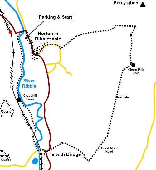
To view route as a dynamic Ordnance Survey map click here. Introduction: Most walkers venturing forth from Horton in Ribblesdale head for Pen y ghent. I am no exception, having climbed it many times over the years, including only a few weeks before this walk. However on this occasion, I thought it might make a change to try a circular route to Helwith Bridge and on up to Great Moor Head. This would provide a ridge walk to the foot of Pen y ghent itself with the chance for views on the way. Unfortunately, contrary to forecast expectations, the area was bedevilled by low cloud and hazy conditions, as you can see from the photos, so views were not at their best. If you are doing this walk and want to make a greater expedition out of it, you could pick up my Pen y ghent and Plover Hill walk - see # on that walk and the corresponding mark below. This would give a walk of about twelve miles altogether. Returning to this walk, it follows the course of the river Ribble, with views to Moughton Scar and the vast quarry there. Unexpectedly, I saw a cormorant! At Helwith Bridge is the Helwith Bridge Inn where you might pick up sustenance but check opening hours. It was originally built in the 1820s as a canteen for the quarry workers. The bridge itself crosses the Settle Carlisle railway, with the chance of seeing steam trains (as long as you time it right!). It is a Grade II listed structure. An interesting feature on this walk is Churn Milk Hole. This is a large sink hole, which sits on a geological fault line. There is a longstanding hope amongst cavers that there might be a pothole here but I do not think any has been found as yet. This walk gives a good view of what might be termed the ‘backside’ of Pen y ghent, an aspect most climbers of the hill will not see as clearly. The walk is on easy to follow paths/tracks. The walk starts at the main car park close to the Crown Inn on the B 6479 at Horton-in-Ribblesdale (SD 808726). Alternatively, you can park at the Golden Lion Hotel at more modest cost. To get there, take the signposted turn off by the river bridge in Settle. Horton is also accessible via train from the Settle Carlisle route. At peak times you will find Horton very busy because Horton is the starting point where many entrants “clock in” for the Three Peaks Challenge. Start: From the car park, turn left, over the footbridge behind the toilets. This brings you out at the river bridge. Turn left over the river, then immediately left following a public footpath fingerpost for “Cragghill Farm 1¼ miles” and the “Ribble Way”.
Follow the riverbank, ignoring a footbridge signposted for Horton. After passing Cragghill Farm, go through a farm gate, then branch off right following a fingerpost for “Ribble Way” and “Helwith Bridge” (SD 808707).
Cross the field in the direction of the fingerpost and about half way along the field at the far side, cross a ladder stile. Walk parallel with what looks like the remains of a walled lane on the left but do not walk in it. Go through a couple of walkers’ gates and cross a small footbridge. Cross a stone stile over a wall and turn right, still following the riverbank. About a hundred and fifty yards further on, the path bends right to go under the railway. Beyond the railway, cross a tarmac lane and go through a kissing gate. Turn left to walk alongside the road. This path has clearly been established to protect walkers from some heavy lorries which use the lane. Arrive at another kissing gate. Cross the gate and go through another kissing gate and follow the fingerpost to Helwith Bridge.
Cross a ladder stile to the rear of the pub, then climb some steps at the far side of the pub car park. Turn left over the bridge.
Follow the road to a junction and turn left following the road sign for “Horton-in-Ribblesdale” and “Hawes”. Follow the road for a hundred and fifty yards or so, then, as it bends left, branch off to the right up a broad stony track (Moor Head Lane), following a fingerpost for “Byway Open To All Traffic” “Dale Head 2¾ miles” (SD 814696). When the path forks (SD 818697), you can go either way eventually to arrive at the same point at Churn Milk Hole. I chose the right fork to climb slightly higher, in the hope of better views although the weather conditions rather inhibited this. However, this is the route I describe. Continue climbing the track after the right fork, until you meet a gate across it. Through this, turn immediately left to follow the wall (SD 824693). Note the ancient boundary stone by the gate. As you continue to gently climb, there are views to Pendle Hill. Cross a gated step stile (SD 830701). Over this are a few boulders where you can perch for a picnic. Continue in the same direction, with the wall on your left, until you reach a ladder stile. Cross this then turn right in the direction of a fingerpost for “Churn Milk Hole”.
Go through a couple of gated stiles, continuing in the direction of the end of Pen y ghent ahead. At SD 835719 arrive at a junction of broad tracks. Churn Milk Hole is to the right. Turn left following a fingerpost for “Pennine Way” and “Pen y ghent 1 mile”.
The broad track gradually narrows to normal footpath proportions and leads to a stone step stile at the top of the ridge. Cross and turn right following the obvious path, which is the end of the alternative route described above. You arrive at the foot of the steep ‘nose’ of Pen y ghent (SD 836728). (# This is the point at which you can if desired follow my route over Pen y ghent and Plover Hill).
To return to Horton in Ribblesdale, turn left here following the fingerpost for “Bracken Bottom 1¼ miles”. Follow the path down for about a mile and a quarter, to meet a road at Bracken Bottom farm (SD 817723). Turn right. Just after passing the school building, turn right over a bridge then left along the road. At the main road, turn right back into Horton, passing the church.
If you need to buy any hiking equipment/clothing before your trip see the Hiking Store All information on this site is given in good faith and no liability is accepted in respect of any damage, loss or injury which might result from acting on it.
| | |||||||||||||||||

.jpg)
.jpg)
.jpg)
%20River%20bridge%20at%20Horton%20in%20Ribblesdale.jpg)
%20Pen%20y%20ghent%20glowering%20in%20the%20gloom.jpg)
%20Cormorant.jpg)
%20Looking%20up%20to%20Moughton.jpg)
%20Moughton%20Nab.jpg)
%20Limestone%20Quarry.jpg)
%20Helwith%20Bridge%20Inn%20and%20River%20Ribble.jpg)
%20View%20from%20Helwith%20Bridge.jpg)
%20Approaching%20Pen%20y%20ghent.jpg)
%20Churn%20Milk%20Hole.jpg)
%20Nose%20of%20Pen%20y%20ghent.jpg)
%20View%20SE%20from%20foot%20of%20Pen%20y%20ghent.jpg)
%20St%20Oswald's%20Church%20Horton%20in%20Ribblesdale.jpg)