
|
|
|
To view route as a dynamic Ordnance Survey map click here. Introduction: This walk from Ribblehead is an easy fairly level walk, avoiding the exertions needed to climb Whernside or Ingleborough, for which Ribblehead is a common starting point. The ascent and descent are each only just over 600 feet. The walk was arranged to aid the recuperation of someone, following a recent replacement hip operation so was of necessity fairly easy – until he is “broken in” once more! Straightforward as the walk is, it nevertheless offers some lovely views of Whernside and Ingleborough with Pen y ghent peeping through occasionally (the links will take you to routes up each of them). The route also passes some limestone pavement, reminiscent of Malham Cove’s top and the cute little church at Chapel-le-Dale. It also passes within “supping distance” of the Old Hill Inn, although it is recommended you double check opening times before relying on it. A downside of the walk is that it involves walking for about a third of a mile along the B6255. This can be quite busy with a fair number of lorries. It can be avoided by turning off the described route at Bruntscar Farm although this would reduce the walk distance by one and a half miles. However you would miss the limestone pavement, church and the Hill Inn! Maybe take the rough with the smooth? The return passes under Ribblehead Viaduct, a masterpiece of Victorian engineering, on the Settle to Carlisle railway line. It was built between 1870 and 1874 by as
many as 1000 navvies. It is 400m (440 yards) long with 24 arches. During
construction the navvies lived in nearby shanty towns, named Batty Wife
Hole, Belgravia and Sebastopol. These were effectively complete communities
with pubs, schools libraries etc. However, conditions were not particularly
sanitary. Between fights, accidents and disease, hundreds were killed. It
was scheduled to be demolished due to its deteriorating state in the 1980s
but was saved by the then Transport Minister Michael Portillo (now of the
Great British Railways and This Week TV programmes fame), who subsequently
said it was “the greatest achievement of my political career”.
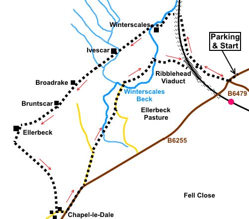
At least one politician with a concrete achievement! Start: From the car parking, head south-west towards the Ribblehead Viaduct, along the B6255. Opposite the junction with the B6479, turn right along the “manicured” path indicated by the fingerpost. When it joins a broad track closer to the viaduct, turn right.
At a fork in the track, just after passing an information board, which tells you about the Ribblehead Locomotive Depot and Brickworks, take the right fork. There will be a chance to see the viaduct up close when the return leg passes under it. The path goes up some stone steps. Ignore the first tunnel under the railway line and stay on the path running parallel to the right hand side of the line. At the next tunnel, turn left under the line, following a bridleway fingerpost (SD 758803). At SD 75380, pass farm buildings and almost immediately, cross a bridge over Winterscales Beck. Continue along the path quickly passing to the left of another farm.
At a junction with another track to the left, ignore this and carry on straight ahead following the fingerpost for “Scar End 5½ miles”. At SD 950799 pass another track on the right, by a bench, keeping straight ahead once more. At the next farm, pass a three way fingerpost and follow “Scar End 4½ miles”. The path passes between the farmhouse and the barn with the “semi-circular” roof, resembling an air-raid shelter. There is a yellow marker on the gatepost, just after the farmhouse. At SD 744795, there is was an impressive waterfall to the right, although there had been recent heavy rain.
The next farm is Broadrake. Ignore the path which bends left just after it and keep straight ahead through the gateway. Arrive at a three way fingerpost by a barn. Follow “Yorkshire Three Peaks” and “Hill Inn 1¼ miles”. At the next fingerpost, follow “Scar End 3½”. Pass Bruntscar Hall (SD738 790) but note that just before this at SD 739790, is a left turn which you can use to shorten the walk and avoid the walk along the B6255 – see Introduction.
Go through the farmyard, in front of the
farmhouse at Ellerbeck (SD 731785) and about three hundred yards beyond it,
cross Ellerbeck Gill and turn left to follow the track alongside its right
hand side. Alongside this section, after about a quarter on a mile, predominately on the right (SD 733781), there are some areas of limestone pavement with their “clints” (the limestone blocks) and “grikes” (the fissures between).
Continue down this track passing the drive to High Scales. At the ‘T’ junction with the road, turn left. Here, you will see the attractive if tiny Parish Church of St. Leonard, which is only 48 feet long and 20 feet wide.
Follow this minor road until it reaches the B6255 and turn left along it for a third of a mile. Take the next left Philpin Lane (SD 724776). Easy to spot because it is just before the Hill Inn! On reaching a cattle grid, turn right to follow a bridle way fingerpost (SD 744782). This was well hidden in the foliage! When it opens into a field, follow the right hand boundary. At the end of the field, you may hear the stream falling into a pot hole, amongst the trees although sight of it is not easy. Go through a gate next to this working your way clockwise around it, though not for very far. Once you have crossed the stream, turn left to follow its right hand bank (SD 745784). Follow this path for about a third of a mile until you reach a tarmac lane (SD 747788). Turn left along it, crossing a cattle grid. After about a quarter of a mile, the lane forks (SD 749792). Turn right, through a gateway, following a fingerpost for Ribblehead. The viaduct is ahead of you. Just short of half a mile later, turn right over a bridge to cross Winterscales Beck once more following the fingerpost for “Ribblehead ½ mile”. Pass under the viaduct, taking the opportunity to wonder at its construction and turn right along the broad track beyond it to retrace your steps to the car parking.
If you need to buy any hiking equipment/clothing before your trip see the Hiking Store All information on this site is given in good faith and no liability is accepted in respect of any damage, loss or injury which might result from acting on it.
| | |||||||||||||||||

.jpg)
.jpg)
.jpg)
%20Ribblehead%20viaduct%20with%20Whernside.jpg)
%20Rushing%20Winterscales%20beck.jpg)
%20Distant%20view%20of%20Pen%20y%20ghent.jpg)
%20Ingleborough%20through%20the%20murk.jpg)
%20Waterfall.jpg)
%20Ribblehead%20Viadust%20from%20Bruntscar.jpg)
%20Ingleborough%20improving%20weather.jpg)
%20Limestone%20pavement.jpg)
%20St%20Leonards%20Church%20Chapel%20le%20Dale.jpg)
%20Lych%20gate%20at%20St%20Leonards%20Church.jpg)
%20Ingleborough%20from%20Ribblehead%20Viaduct.jpg)