
|
|
|
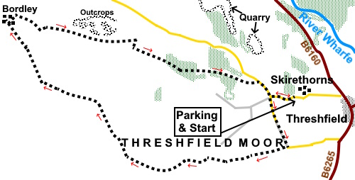
To view route as a dynamic Ordnance Survey map click here. Introduction: This walk circuits Threshfield Moor passing through Bordley, sometimes known as Bordley Town. The route passes some lovely limestone scenery typical of the Yorkshire Dales and gives good views too. I selected this route following the incessant rains of the 2023/24 winter, when mud was in plentiful supply in the hope that the clear tracks included would be less muddy. In that respect it was largely successful with the worst mud being in gateways. Bordley is a small farming hamlet named “Borelaie”
in the Domesday Book. It evidently had two “carucates” to be taxed (being the
amount of land tillable
by a team of eight oxen in a ploughing season. Most of the walk crosses Access Land but it
all follows distinctive Rights of Way. The walk starts from the entrance to the quarry on Skirethorns Lane at Threshfield where there is a very wide area where you can park safely. To get there, take the B6160 NW from Threshfield (near Grassington). Just after the filling station, turn left on to Skirethorns Lane. The quarry entrance is just short of half a mile from the B6160. Start: Exit the quarry entrance and turn right along the road. You will come to a crossroads with tarmac going right and left, with a stony track straight ahead. Turn left, following a sign for Grisedale Holiday Cottages (SD 978639).
Continue up the lane passing Grisedale Holiday Cottages. Arrive at a ‘T’ junction where the road turns left. Turn right along the broad stony track (SD 981632). You follow this for a mile and a half up on to Threshfield Moor.
You reach a gate with a two-way fingerpost. Go through the gate and turn right following the Public Bridleway sign.
Reach a fork (SD 962629) and keep straight ahead. Reach a gate at SD 958630 and turn right following the fingerpost to “Malham Moor Lane”.
In less than a quarter of a mile, you will pass a footpath off to the right closely followed by one to the left. Ignore these and stay on the broad track. After a further quarter of a mile, you reach two gates opposite each other. Turn off through the left gate (SD 955637) then bear right at about 45°. At the far side of the field, go through another gate and continue in roughly the same direction as you approached it, along a slightly less distinct path. Pass a fingerpost at SD 951639. Follow the direct of the finger for Public Bridleway following the wall on the left. There are good views over Winterburn Reservoir here.
Follow the path to a gate and go through it at the corner, bear left. Keep to the right of an isolated rounded rock in the field. And head for the gate in the wall ahead which you will soon see. Go through the gate where there is a four-way fingerpost (SD 947641). Turn right following the “Public Bridleway to Bordley 2/3 mile”.
At Bordley, follow the track ahead, ignoring one off to the left. Half way through the hamlet there is a three-way fingerpost. Turn right following “Public Bridleway to Malham Moor Lane”. After just over a hundred yards, turn right in the direction of a fingerpost for “Threshfield 3 miles”. Follow the wall on the right down to a corner and turn left, continuing to follow it, passing an upright stone with white paint on the top. After less than a hundred yards, turn right over a gated step stile (SD 947648). There is now quite a steep climb parallel with the wall on the right and passing a large water tank. As you reach the top, there are plenty of rocks, should you be looking for a sandwich stop. Continue following the path through a series of gated step stiles and pass a lime kiln and old barn on your left.
Cross an ungated stile where there is a four-way fingerpost. Keep straight ahead following the sign for “Wood Nook”. The path drops down to a double walkers’ gate, by a barn (Height Laithe) (SD 560646). Go through this and straight ahead across the yard. At the far side go through a gate and follow the public footpath fingerpost.
Climb the short hill for about a hundred yards then, just as it starts to level out, turn left through a walkers’ gate and following the wall on the left.
The path is obvious and drops down, passing to the right of a farmhouse, abandoned but still in good condition (Height House) (SD 963644). Beyond the farmhouse is a double gated stile. Cross this and turn right following the wall on the right. The path soon bears to the left of a small valley. Further left are limestone outcrops and a wood of small trees.
The path initially passes to the right of a caravan park (Wood Nook) before turning into it and joining its drive. Follow this to the road and turn right. You soon reach a junction which you should recognise from the outward journey. Turn left to return to the parking area. If you need to buy any hiking equipment/clothing before your trip see the Hiking Store All information on this site is given in good faith and no liability is accepted in respect of any damage, loss or injury which might result from acting on it.
| | |||||||||||||||||

.jpg)
.jpg)
.jpg)
%20View%20over%20Wharfedale.jpg)
%20View%20over%20Skirethorns.jpg)
%20View%20towards%20Threshfield%20Moor.jpg)
View%20to%20Threshfield%20Quarry%20and%20Buckden%20Pike.jpg)
%20Field%20Barn%20with%20Buckden%20Pike.jpg)
%20Moorland%20View%20with%20Pendle%20Hill.jpg)
%20Telephoto%20shot%20to%20Sharp%20Haw%20and%20Rough%20Haw.jpg)
%20View%20to%20Winterburn%20Reservoir.jpg)
%20En%20Route%20to%20Boardley.jpg)
%20Lime%20Kiln.jpg)
%20View%20to%20Cave%20Scar%20and%20Height%20Cave.jpg)
%20Field%20walls%20and%20many%20rocks!.jpg)
%20Rock%20outcrop%20and%20hawthorn%20trees.jpg)