
|
|
|
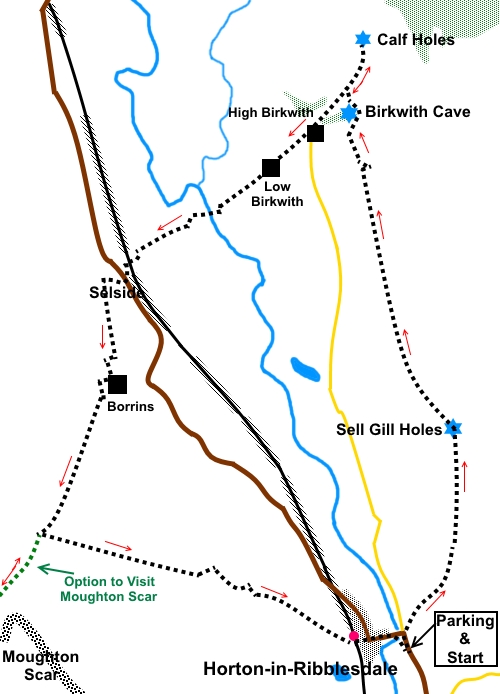
To view route as a dynamic Ordnance Survey map click here. Introduction: This walk from Horton-in-Ribblesdale takes you on a circular low level walk around the upper reaches of the Ribblesdale valley. The distinctive profile of Pen y Ghent is evident for much of the walk and there are also good views of Whernside, with Ribblehead Viaduct and the rear of Ingleborough. The walk also takes you past the three interesting pothole entrances of Sell Gill Holes, Birkwith Cave and Calf Holes. These are next to the footpaths we follow and are easy to find. Whilst it is interesting to see the streams disappearing underground, these potholes are for experienced cavers with the right equipment and as a “mere” walker, entry should not be attempted. Keep well back from the entrances and beware some steep drops. At Calf Holes, there are a number of rocks to sit on which make for a pleasant picnic stop. The walk is straight forward without any severe gradients. There are some muddy sections so, after wet weather, you will appreciate gaiters. Horton-in-Ribblesdale
is of course the main starting point for the Yorkshire Three Peaks walk
which begins at the Pen-y-ghent Café. They operate a clock card system and
the idea is to complete the walk of some 24½ miles over Alternatively, you can adopt a more leisurely approach by tackling each hill on separate occasions, making for three great days out – see the links in the first paragraph. Horton is dominated on one side of the valley by Pen y Ghent and on the other by the truly huge limestone quarry, covering around 80 hectares. It has the consent and reserves to keep going for about another 70 years! I have started this walk from the main car park in Horton where there are public toilets. However you can also park for about half the price at the Golden Lion Hotel. There is also roadside parking just to the west of the river. To get to Horton-in-Ribblesdale, take the B6479 from Settle. There are no facilities en route, but two pubs and a café on return to Horton. Start: Turn left out of the car park (SD 808726) and walk along the road to the Crown Inn. The route continues through the pub car park, from the rear left hand corner signposted “Pennine Way, Restricted Byway and Birkwith Moor 3 miles”
Follow this clear track for just over a mile, to a stream running down the hillside on the right. This disappears into a pot hole at Sell Gill Holes. The entry on the right of the footpath is Sell Gill (wet) and on the left of the path, Sell Gill (dry) (for obvious reasons!) (SD 812744).
Just past here, there is a ladder stile by a ruined barn (SD 811744). Cross this and turn right through a gateway behind the barn to follow the footpath. There is a fingerpost marked, with amazing precision, for “Birkwith 17/8 miles”. However the positioning of this could lead you to believe you need to walk along a broad track to the right of the wall – which leads to a dead end! If you miss this, there is a gateway in the next field to regain the path which is obvious on the ground.
Follow the path until you pass through two gates close together and where there is a two way fingerpost, pointing left and straight ahead. Take the straight ahead route. At the next stream (SD 804765), turn right to follow the path briefly along its right hand bank. After 50/60 yards, there is a slit stile. Go through this and turn left to resume the route. The path is clearly trodden. This is easier than trying to scramble down to a small footbridge to cross the stream.
As you approach a plantation, the path forks. Take the right hand fork. Round the right hand end of the plantation and turn left along a broad track to a gateway. To visit Birkwith Cave, turn sharp left through the gate and follow the wall closely to a stile. A short walk through the trees on a clear path takes you to the cave mouth (SD 804770). Beware steep drops into the stream below.
Return to follow the track to a junction with another main track. The onward route for the walk is to turn left but to visit Calf Holes, first turn right. A few yards further on, go through a gate where there is a fingerpost (SD 805774). Follow the left direction, signposted for Pennine Way and Cam End.
After 350 yards or so, there is a ladder stile on the right and Calf Holes is immediately over this (SD 804776). Once over, take great care near the pot hole as the limestone will be slippery where wet and it’s a long drop!
Retrace your steps to rejoin the main route. Follow the track down to High Birkwith Farm (SD 800768). Just after passing the white painted farmhouse, turn right over a stone step stile to follow a fingerpost for Selside 1¼ miles. Keep to the left hand side of the field and cross a ladder stile into the trees. Exit the trees opposite the entry point and head down the field, towards the farm at the bottom and cross a gated stile in a corner. Continue towards the farm, passing to the right of some sheep pens. Go straight through the farmyard and head to a gate by the stream. Follow to the left of the fence running along left hand bank of the stream. Cross a gated stile at the end of the field. Continue following the left hand bank of the stream, crossing another stile. Cross two footbridges close together (SD 792762) then, go through a gate ahead and turn slightly right, to follow the fence on the left. Go through a gate in the left corner of the field, to follow a short walled track to a junction with another, where you turn right to follow a fingerpost for “Selside 1/3 mile. Pass a farm and go under the railway bridge to the hamlet of Selside. At Selside Farm, turn left past the red telephone box and at the road, turn left.
Walk along the road for no more than 150 yards and turn right up a driveway to follow a fingerpost for Borrins ¾ mile (SD 785756).
Pass between the dwellings and at the far side, cross quite a high stone step stile then keep straight ahead, following the left hand boundary initially, then head towards the farm visible to the right on a hilltop. Cross a step stile by the farm, then head very slightly right to another step stile. Although not the official footpath route, in this field, I turned right through a gate to join the main access track, turning left to the farm Borrins. Opposite Borrins farmhouse (SD 784748), turn right along a broad track. Look out for a ladder stile on the left. Cross the stile and follow the left hand boundary of the field until the field narrows, then go through the farm gate on the right hand side. Follow the clear, broad track across the field, which is clear on the ground and clearly marked with yellow marker posts. At a four way finger post. Turn left along Sulber Nick for “Horton-in-Ribblesdale 2 miles” (SD 778735). However, before turning down this path, it is worth continuing ahead for half a mile to see the dramatic Moughton Scar, before returning to this point.
After about 1¾ miles, the path comes out at Horton station. Keep straight ahead to cross a footbridge, which leads you back to the car park. If you need to buy any hiking equipment/clothing before your trip see the Hiking Store All information on this site is given in good faith and no liability is accepted in respect of any damage, loss or injury which might result from acting on it.
| | |||||||||||||||||

.jpg)
.jpg)
.jpg)
%20Pen%20y%20Ghent.jpg)
%20Panorama%20over%20Horton.jpg)
%20View%20to%20Whernside.jpg)
%20Sell%20Gill%20Hole%20(wet).jpg)
%20Sell%20Gill%20(Dry).jpg)
%20Barn%20and%20Ingleborough.jpg)
%20Ingleborough%20and%20Whernside.jpg)
%20Limestone%20Outcrop.jpg)
%20Birkwith%20Cave.jpg)
%20Whernside%20with%20Ribblehead%20Viaduct.jpg)
%20Ribblehead%20Viaduct.jpg)
%20Stream%20disappearing%20into%20Calf%20Holes.jpg)
%20Hamlet%20of%20Selside.jpg)
%20Settle%20Carlisle%20railway%20and%20Pen%20y%20Ghent.jpg)
%20Moughton%20Scar.jpg)
%20Limestone%20pavement.jpg)