
|
|
|
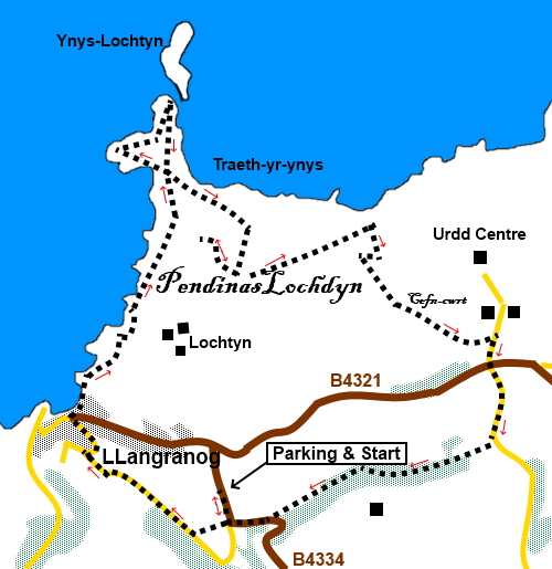
To view route as a dynamic Ordnance Survey map click here. Introduction: This walk is a pleasant cliff and countryside walk. The cliff section provides stunning views of Cardigan Bay and there is a chance of seeing bottlenose dolphins. Llangranog (sometimes spelt Llangrannog), named after St Crannog, is a small seaside village, at one time a small port. The older part of the village stretches up the valley. It is a popular holiday spot with a smattering of pubs, cafes etc. There is a prominent rock called Carreg Bica. Legend has it that this was a giant’s tooth which was causing him toothache and which fell out, thanks to the intervention of a helpful dwarf! Alternatively, it is a sea stack created by a cave collapse, which sounds more likely! An interesting feature is the grass topped island of Ynys Lochtyn which sits off a small peninsula (and which was created by the above giant as a thank you to the dwarf, who wanted to live on an island!). It is cut off from the mainland except at very low tide. It is worth venturing on to the peninsula to see the waves crashing against the island and there are good views of Cardigan Bay, stretching to the Llyn Peninsula if the air is clear. There is a vein of white quartz on it which stands out quite clearly. With a bit of a struggle, you could possibly get on to the island but beware the tides as it gets cut off. I did not venture! The route takes you to the hill of Pen y Badell, which evidently means “upturned saucepan”. On top is the site of an ancient settlement of Pendinas Lochdyn, a Middle Stone and Iron Age fort. Clearly this would have been a great spot for an ancient fort settlement as it commands views all around, not least of Cardigan Bay. If you look very closely you can spot the remnants of probable ancient earthworks but I found them hard to spot. The walk is easy, once you have climbed the steps from Llangranog! The
walk starts from a free car park on the outskirts of Llangranog. To get
there, turn NW off the A427 between New Quay and Cardigan at Brynhoffnant,
on to the B4334. The car park is on the left, after two miles, opposite a
caravan park, after a couple of very sharp bends. Start: Exit the car park on to the road and turn right (SN 316538). Turn right at the road junction, after only about a hundred and fifty yards. Immediately, turn right again on to a footpath, descending some steps. After crossing a stream, enter a field and head for the far right hand corner. Cross a stile and ascend some steps to a tarmac lane. Turn right to follow it. At the road junction, turn right into the village of Llangranog.
Cross the top of the beach (with the sea on your left) to pick up the coast path, indicated by a fingerpost and climb some steps. At the top are a bench and an information board about the immediate area.
Follow the obvious coast path. Eventually, it joins another, through a walkers’ gate, at a three way fingerpost. Keep left on the coast path. You arrive at the peninsula by the tidal island of Ynys Lochtyn (SN314551). It is worth a brief exploration of the peninsula.
After exploration, return to the coast path and follow it as it curves clockwise round the hill Pen y Badell. The map shows Pendinaslochdyn, the site of the ancient hill fort. To get there; ignore a footpath leading off left at SN 317549. Reach a broad track which climbs the hill to a very ugly building, clearly some sort of Government structure. However the purpose of the climb is for the magnificent view and to try to spot the hill fort remains.
Return along the track to the coast path and turn left.
Go through a walkers’ gate within a metal, larger gate. Further along the coast path, go through another walkers’ gate. Immediately on the right is a second one (SN 322549). Leave the coast path here and follow the right hand field boundary to the corner of the field where you go through another walkers’ gate. Once through this gate, head away from the fence at about 45° and head for the brow of the hill. As you reach it, you will see the far right corner of the field. Go through a walkers’ gate (SN 323546). turn left following the left hand field boundary in the direction of the yellow footpath arrow. In the next field, also follow the left hand boundary.
Go through a walkers’ gate at the end of the second field, following the obvious path to the road where you turn right. At the cross roads, go straight over. Follow the road downhill, over a stream and up the other side for just under a quarter of a mile from the junction. Immediately after the first left bend in the road, turn right along the footpath to Pigeeonford Farm (SN 327541). Go through the white painted gateway to follow the public footpath route up the drive. There is a small footpath sign but it is easily missed. The path then passes between the white painted buildings and there was a yellow arrow indicating it. Follow the obvious path through the woods ignoring a broad track off to the left at one point and further on a path to the right. On reaching the road, turn right to return to the car park. If you need to buy any hiking equipment/clothing before your trip see the Hiking Store All information on this site is given in good faith and no liability is accepted in respect of any damage, loss or injury which might result from acting on it.
| | |||||||||||||||||

.jpg)
.jpg)
.jpg)
%20Llanranog%20stretching%20up%20the%20valley.jpg)
%20Carreg%20Bica.jpg)
%20Sea%20front%20at%20Llangranog.jpg)
%20View%20along%20the%20coast.jpg)
%20Peninsula%20and%20Ynys%20Lochtyn.jpg)
%20Fungus%20on%20the%20peninsula.jpg)
%20Looking%20north%20along%20Cardigan%20Bay.jpg)
%20Ynys%20Lochtyn.jpg)
%20View%20south%20from%20Pen%20y%20Badell.jpg)
%20Pen%20y%20Baddel%20with%20Ynys%20Lochtyn.jpg)
%20Berries.jpg)