
|
|
|
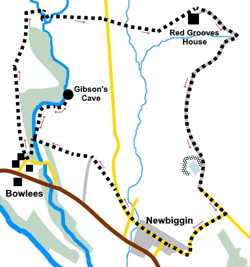
To view route as a dynamic Ordnance Survey map click here. Introduction: This is a walk with some lovely scenery, visits Gibson’s Cave and passes through the tranquil village of Newbiggin. However there are some ‘hard work’ sections involving steep descend and ascents into small valleys and the fording of streams. I would not recommend the walk after heavy rain as the streams could be impassable. Gibson’s Cave comes with the obligatory legend! It is supposedly named after a 16th Century outlaw William Gibson, a ‘lovable rogue’, who hid away in a recess behind Summerhill Force (waterfall) at the cave. Popular locally, friends kept him supplied with food and dry clothing. The cave and Summerhill Force which flows over it can only be accessed from the one side as described and this is a ‘dead end’, so you have to return to the car park to continue the route. The walk passes Red Grooves House, now a ruin. This is at the eastern end of the ‘Coldberry Gutter’, a ‘hush’ where (not surprisingly) ‘hushing’ took place in the 18th Century as part of the lead mining process. This ancient technique, dating back to at least Roman times, used the sudden release of water from dams to scour the hillside, washing (in this case) lead ore from the hillside. The route passes a large, quite attractive lake in an old limestone quarry, above Newbiggin. The walk starts from the free car park at Bowlees which is situated on the B6277 between Barnard Castle and Alston, about three miles NW of Middleton-in-Teesdale. Start: From the car park (NY 907282), walk past the stone building with the information boards and past the toilets following the sign for Gibson’s Cave. When the path forks, keep right. You pass an old limestone quarry and information board. Climb the steps ahead but before you do, it is worth venturing to the edge of the stream, where there is a nice view of a waterfall. Follow the path above the steps to Gibsons's Cave..
After the Gibson's Cave, you have to retrace your steps to the car park. Turn right there to cross the footbridge to the Bowlees Visitors’ Centre. Ignore the first footpath to the right into the trees and go clockwise round the visitor’s centre. Go through a walker’s gate and follow the footpath up the hill. The path starts by running parallel with the trees on the right. As you get to the corner of the trees, go through a gate. The official path then follows the wall on the left briefly before bearing off to the right but to be honest, the easiest thing is to simple follow the line of the steep little valley on the right.
Look for where the section of the field boundary at the other side of the valley abruptly points towards you in a ‘V’ formation. Here, in the wall, to the left of the ‘V’, you should see a stone step stile. You need to descend the steep valley somewhere here and climb to and cross this stile (NY 906289). The field you enter is rough pasture. Follow the wall on the right to the trees then turn left to follow their boundary. You could just head straight across to the corner of the trees but it is quite hard going. At the end of the trees, cross a stone step stile into a field. Keep straight ahead for just over a hundred yards where you theoretically meet a crossroads of paths (NY 907293), though in practice, this was invisible when I did the walk. Turn right at 90° here and head for the steep valley, through which runs Bowlees Beck (or possibly Wester Beck at this point). Look out for a grassy ‘ridge’ down which you descend, curving right, to the valley floor, by the wall, which is the easiest place to cross the stream.
Go through a kissing gate at the far side of the stream. You arrive at a second stream (Flushimere Beck). I found the best way to cross was to turn briefly left for a few yards, where there were some suitable rocks (NY 909293). Head up the hill, bearing left. I recommend a zig-zag to even out the slope! As you near the top, you will see a corrugated steel barn. Head for that and cross the style at its right hand side. Turn left at the barn to a point about a third of the way (from the left), along the far wall of the field, where there is a stile. Cross the stile, passing under some power lines. Cross the field to the right of its high point. If you look at the hill in the distance there is the grey mass of an old spoil head. If you head for that, you will be going in the right direction. Exit via a stone stile into the road (NY 913292). Cross the road and go through the kissing gate and follow the direction of the fingerpost. Exit from this field is supposed to be via (I assume) a stile in the far wall but I could not find it and I think the approved exit must now be through the left of the two adjacent gates you can see. Then head for the diagonally opposite corner of the field, again using the grey spoil heap as your aiming point. Go through two gates in quick succession and head up to the ruined house (Red Grooves House) (NY 919293).
Circle the house clockwise, to join its access track which leads you through old mine workings. Stay on the clear track for the next mile, passing a flooded quarry. The stony track then becomes a tarmac road.
At the road junction (NY 922278), turn right and follow the road down and through the village of Newbiggin. There are some footpaths where you could cut the corner if you wanted but I opted for the easy walk down this quiet road which has good views.
Keep straight on through the village and as you leave it, head up the hill, following the road sign for Westgate. There is also a blue sign warning that the road is unsuitable for heavy goods vehicles.
Just before the road bends to the right, look out for a gate set back at an angle and turn left, over the stile, to follow the public footpath fingerpost (NY 913280). Head across the field in the direction of the white house ahead. In the next field, keep to the left of the old barn and cross the step stile and turn left, as indicated by a yellow arrow (NY 911282) and follow the left hand field boundary in this and the next field At the end of this second field, go through a gate on the left to return to the Gibson’s Cave woods. Turn left back to the car park. If you need to buy any hiking equipment/clothing before your trip see the Hiking Store All information on this site is given in good faith and no liability is accepted in respect of any damage, loss or injury which might result from acting on it.
| | |||||||||||||||||

.jpg)
.jpg)
.jpg)
%20Waterfall%20on%20the%20way%20to%20Gibson's%20Cave.jpg)
%20Gibsons%20cave%20and%20waterfall.jpg)
%20Looking%20south%20to%20Holwick%20Scars.jpg)
%20View%20along%20Teesdale.jpg)
%20View%20to%20Bowlees%20Beck.jpg)
%20Waterfall%20on%20Bowlees%20beck.jpg)
%20Red%20Grooves%20House.jpg)
%20Quarry%20Above%20Newbiggin.jpg)
%20Descending%20the%20road%20to%20Newbiggin.jpg)
%20Hedgecutting%20with%20pride.jpg)