|
Egglestone
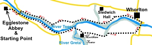
Abbey to Whorlton
|
Starting
point and OS Grid reference:

Free
car park at Egglestone Abbey (NZ 062151)
|
Ordnance
Survey Map
OL31
North Pennines – Teesdale and Weardale & OS Explorer 304 Darlington
and Richmond.
Buy this map from
List
of OS Maps
.Note: If you use OS Maps on-line, you can download this route via this
link.
| |
Distance: 6.4
miles
|
Date of Walk: 6
October 2014
| |
Traffic light rating:

(For explanation see My
Walks page)
| |


For advice on .gpx files see
My
Walks page
|

Click
the PDF logo above to give a printable version of this walk without the
photos.
|
To
view route as a dynamic Ordnance Survey map click here.
Note: This
walk is now unlikely to be feasible in its entirety until Summer 2026 (revised
date - yet again!), due to
closure of Whorlton Bridge. The date keeps being put back. See the Durham
County Council website for the latest position.
Introduction:
This Teesdale walk to
Whorlton Village takes you along an attractive section of the River Tees. It
passes Mortham Tower, a Grade I listed, medieval house with a pele tower,
supposedly built during the reign of Henry VIII and one of the oldest
inhabited houses in the north. It is privately owned. It is close to Greta
Bridge where the waters of the rivers Greta and Tees meet in a dramatic
setting.
En route, you will see a number of unusual,
cast iron parish boundary markers.
The walk starts from a free car park at
Egglestone Abbey. The abbey was founded in the 12th century and was occupied
by Cistercian “White Monks”, a reference to the white choir robes they
wore over their habits (as opposed to the Benedictines who wore black). They
were not a wealthy order, relying on self sufficiency – agriculture,
brewing etc. Later, education and academic activities predominated. Like
most monasteries, it suffered from Dissolution in 1538, under Henry VIII and
fell into disrepair, although the east range evidently was occupied by
estate workers until the late 1800s.
As you approach the abbey, it looks quite
complete and impressive and only when you get closer does its fragmented
nature become apparent. However as it is an unmanned English heritage site
and so “free,” it is worth a look.
Whorlton is a charming and classy village,
with a large green, church and a good pub (Bridge Inn). Whorlton is
approached by means of an attractive suspension bridge, still supported by
its original chains. This was built to replace an earlier bridge swept away
by floodwaters in 1829 and opened in 1832. To stand on it as a car crosses
is quite strange! Alongside is the old toll house.
The OS map still shows “Whorlton Lido”,
which at one time was a popular tourist spot with natural swimming pools in
the river and even a miniature railway. However as far as I can gather, the
area was bought by a local and shut down. It is now private land and there
is no access and nothing to see.
Refreshment opportunities are available at
the Bridge Inn in Whorlton (check opening times) and one or two picnic spots
along the way.
The walk starts from Egglestone Abbey car
park. To get there, take the B6277 south from Barnard Castle and about half
a mile after the river bridge, turn left along Abbey Lane, signposted
“Egglestone Abbey 1¼ miles”. The lane to the abbey is on the right
after a mile.
%20Egglestone%20Abbey.jpg)
%20Part%20of%20Egglestone%20Abbey.jpg)
%20Undercroft.jpg)
Start: From the abbey car park (NZ
062151), walk back down the road and turn right at the road junction.
At the traffic light controlled bridge, look
out for the footpath to the right of the bridge, before crossing the bridge.
Turn right along this footpath to follow the Teesdale Way fingerpost (NZ
066149).
After 50 yards or so, the path zig-zags back
on itself, to follow the riverbank more closely.
%20Early%20section%20of%20footpath.jpg)
After crossing a stream via a couple of
stepping stones, the path climbs some steep steps to a field. Turn left
here.
Follow the path to a tarmac drive to houses.
Turn left along this, again following a Teesdale Way sign. At NZ 085145,
described as Meeting of The Waters on a notice, the River Greta flows into
the Tees.
%20Meeting%20of%20the%20waters.jpg)
%20Meeting%20of%20the%20waters%20looking%20along%20River%20Greta.jpg)
%20River%20Greta%20from%20Greta%20Bridge.jpg)
Cross Greta Bridge (NZ 085144) and shortly after, you enter the
estate of Mortham Tower. Follow the drive and, as it turns right to the
house, turn left to follow the yellow arrow denoting the Teesdale Way.
%20Mortham%20Tower.jpg)
The path now follows the banking at the top
of a field, for some way, with good views across the valley. As you leave
the Mortham Tower estate via a stile, turn left and follow the field
boundary.
%20Parish%20Boundary%20Marker.jpg)
When you get to the opening into the field
beyond, do not go through it but turn right, keeping the wall on your left.
Pass the ruin of a farm and keep straight ahead. A yellow arrow directs you
to follow the right hand boundary of the next field.
Through the next gate, the path bears
slightly left. Follow the line of the power poles and when the ground dips
to the left, you will be able to see the road. Aim for the stile by the
“road bends” sign and turn left along the road and over the suspension
bridge (NZ 107145).
%20Whorlton%20suspension%20bridge.jpg)
%20View%20from%20suspension%20bridge.jpg)
%20Toll%20House.jpg)
As the road bends, just to the right of the
old toll house, there is a short steep footpath which brings you out at the
village of Whorlton, by a continuation of the Teesdale Way, which is your
onward route. However, it is worth having a look round the village, with its
attractive St Mary’s Church and village green and perhaps taking
sustenance at the Bridge Inn pub, before continuing.
%20St%20Mary's%20Church%20Whorlton.jpg)
Return to the Teesdale way and follow what is
to start with a very clearly defined and fenced footpath. It is at a high
level above the river, with good views. The path opens into a field via a
walkers’ gate. Follow the left hand boundary. The route is clearly
arrowed. This is quite a good spot for a picnic.
%20Picnic%20spot%20view.jpg)
After a brief spell through some woods, go
straight ahead, through a metal gate following the Teesdale Way signs.
Follow the top of the banking as it curves to the left and descends to a
walkers’ gate. Go through the gate and follow the edge of the trees for
quite a way, crossing a stream via a narrow footbridge, with the now
familiar steel marker posts.
You leave the edge of the trees (NZ 084146),
going through a walkers’ gate into a large field. This has two distinct
levels. Keep straight ahead on the higher level. Head for the right hand
corner, where there is a walkers’ gate. Go straight ahead, indicated by
the Teesdale way arrow.
Half way across the field, there is a ditch
(NZ 080147) and a piece of fencing, around a water trough. From here, bear
slightly left. As you get closer to the wall, you should see the stone step
stile. Cross this and head left, for the diagonally opposite corner of the
field.
Cross the stile here and follow the edge of
the trees (NZ 077146).
Over a couple of fields, then after going
over a stile, look out for a not easily spotted path on the left, into the
woods. Go through the walkers’ gate, set back a little from the field and
turn right, indicated by a Teesdale way arrow.
%20River%20Tees%20view.jpg)
The path descends through the woods. At a
‘T’ junction, turn right. You are now close to the river. The path
arrives at the bridge where you began the walk. Retrace your steps to the
abbey car park.
If you need to buy any
hiking equipment/clothing before your trip see the Hiking
Store
All information on this
site is given in good faith and no liability is accepted in respect of any
damage, loss or injury which might result from acting on it.
|


.jpg)
.jpg)
.jpg)