|
Coverack to Kennack Sands
|
Starting
point and OS Grid reference:

Coverack
Harbour (SW 785182)
|
Ordnance
Survey Map
OS
Explorer 103 – The Lizard - Falmouth and Helston.
Buy this map from
List
of OS Maps
Note: If you use OS Maps on-line, you can download this route via this
link.
| |
Distance: 8.3 miles
| |
Traffic light rating:


(For explanation see My
Walks page)
| |


For advice on .gpx files see
My
Walks page
|

Click
the PDF logo above to give a printable version of this walk without the
photos.
|
To
view route as a dynamic Ordnance Survey map click here.
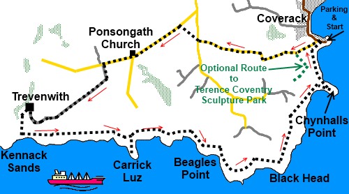
Introduction: This
walk is from Coverack, a typical
Cornish fishing village with an attractive harbour and beach on the eastern
side of the Lizard peninsula, to Kennack Sands. Kennack Sands are an
important geological site and part of the Lizard National Nature Reserve.
They have been declared a Site of Special Scientific Interest.
There is also an
opportunity to see the Terence Coventry sculpture park if you have time but
be warned, you are likely to spend longer there than you expect as it is
fascinating. Click the link for the separate description of this diversion.
Parking is “on
street” in Coverack but this is limited and the bulk of the parking spaces
are on the northern approach to the village on the B3293, where there is an
“honesty box”. There is also a pay and display car park and toilets next
to it. There is also a small “honesty box” car park to the rear of the
Paris Hotel (by the harbour) but chances of there being space are slim.
The bar at the
Paris Hotel (names after a ship which ran aground in the 19th
century) provides for welcome refreshment at the end of the walk and there
are other alternatives in the village.
Some of this walk
takes place on roads but these are quiet lanes with little traffic. Overall,
this is an easy walk. There are just a couple of steepish climbs from two
coves and for this reason, I have awarded the amber traffic light.
The walk starts
from Coverack harbour.
To get to Coverack,
follow the B3293, off the A3083 from Helston to Lizard.
%20Coverack%20Harbour.jpg)
Start: Walk up the steep road west from the harbour
(SW 785182), passing a
yellowish brick house on the
left bearing a tablet in honour of Elizabeth Coad. As the road turns sharply
right, note the post on the left indicating the Coast Path which will be
your return point. Continue on the road and, at the top of the rise, pass
the school and the youth Hostel.
Just
past the school play area is a junction on the left (SW 780180) which will
take you to the Terence Coventry sculpture park, if you have the time –
see my other walk description Coverack to the Terence Coventry Sculpture
Park. Otherwise, stay on the road for a mile, until you reach a ‘T’
junction opposite a house called Penhallock (SW 766182). Continue on a
footpath straight ahead to the right of the house. The footpath is like a
green tunnel and when it ends at another road (SW 763184), turn left.
%20Tunnel%20Footpath.jpg)
%20Pretty%20Cottage.jpg)
Pass Ponsongath
Methodist Church, ignoring the left turn. At the next junction, which is the
farm lane to Trevenwith Farm (signed), turn left (SW 751178).
Ignore the left
turn to Poldowrian and further on one to Wild Acres.
On reaching
Trevenwith Farm (SW 740172), go left in the centre of the farmyard passing
through a gateway in the direction indicated by yellow footpath arrows and
proceed to the diagonally opposite corner of the field and go through
another gate.
The path bends
round to the right. Follow the obvious track as it gently descends and when
it opens into a field, follow the left boundary.
Go through another
field, again following the left boundary. Pass through a gate at the end of
the field, then follow the obvious path between the hedges to the coast,
joining the South West Coast Path at SW 739168, clearly indicated by a
marker post bearing the acorn symbol. Turn left here, although it is worth
spending a little time to enjoy the lovely Kennack Sands.
%20First%20Sight%20of%20Kennack%20Sands.jpg)
The route back to
Coverack is now simply a case of following the Coast Path. There are a
couple of steepish climbs from Downas Cove (SW 764168) and especially
Beagles Cove (SW 769165).
%20Kennack%20Sands.jpg)
%20Spernic%20Cove.jpg)
%20Lankideen%20Cove.jpg)
You pass through
the National Trust land at Beagles Point, Black Head (where there is an old
coastguard station and where I witnessed the Royal Naval Air Sea Rescue
practising) and Chynhalls Cliff.
%20Air%20Sea%20Rescue%20Practise%20at%20Black%20Head.jpg)
%20Wild%20Flowers%20by%20the%20Coast%20Path.jpg)
There are two
promontories at Carrick Luz and Chynhalls Point where ancient forts are
marked on the map but there is little evidence now.
%20Approaching%20Coverack.jpg)
The footpath
returns to Coverack along the front of a row of whitewashed cottages. Turn
right at the end to reach the harbour.
If you need to buy any
hiking equipment/clothing before your trip see the Hiking
Store
All information on this
site is given in good faith and no liability is accepted in respect of any
damage, loss or injury which might result from acting on it.
|


.jpg)
.jpg)
.jpg)