|
Lizard
Point
|
Starting
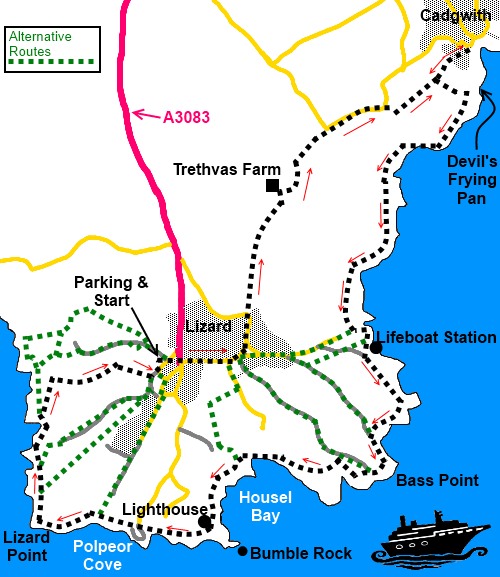
point and OS Grid reference:

Lizard
village (SW 703126). Large car park (honesty box)
|
Ordnance
Survey Map
OS
Explorer 103 - The Lizard – Falmouth and Helston.
Buy this map from
List
of OS Maps
Note: If you use OS Maps on-line, you can download this route via this
link.
| |
Distance: 6.2 miles
| |
Traffic light rating:

(For explanation see My
Walks page)
| |


For advice on .gpx files see
My
Walks page
|

Click
the PDF logo above to give a printable version of this walk without the
photos.
|
To
view route as a dynamic Ordnance Survey map click here.
Introduction:
This easy walk from Lizard (the
village) takes in the old, very picturesque village Cadgwith with its
thatched cottages and Lizard Point, the most southerly point on the British
mainland. There are also various other interesting things to see.
Lizard village itself is rather spoiled by
its homage to tourism but it is a very useful start point partly because
there is a large amount of parking (voluntary charge for charity) but mainly
because in relation to the walk it is like the hub of a wheel with many
footpaths as the spokes. This means that the walk is easily lengthened or
shortened according to circumstances, although depending on which
“spoke” you pick, you may miss some of the points of interest. The route
described includes all the following:
- The Devils Frying Pan
- Church Cove
- Lizard Lifeboat Station
- Bass Point
- Bumble Rock
- Lizard Point Lighthouse
- Polpeor Cove and the old lifeboat
station.
In late spring/early summer, the cliff tops
are a mass of wild flowers including the intriguingly name Hottentot Fig, a
South African invader, which blankets the cliffs at Lizard Point. There is
also the possibility of seeing a variety of sea and marine life.
The open grassland to the NW of Lizard Point
has been awarded Site of Special Scientific Interest due to the great
variety of rare and wild flowers, best seen between spring and mid summer.
As stated, the walk starts from Lizard
village. To get there, take the A3083 from Helston to Lizard.
There are toilets and various choices for
refreshment in both Lizard and Cadgwith.
Start:
In the main car park area in Lizard (SW 703126) with your back to the toilets,
turn right and go straight across the sets of cross roads and walk along
Beacon Terrace, which becomes Cross Common.
Pass the school, curving left past the postbox, signposted Helston 10 miles.
Ignore the right turn signposted to the Lifeboat Station and Church Cove and
a second also to the Lifeboat Station
As you get to the edge of the village, on a
left hand bend (SW 708129), go straight ahead over the stile following the
public footpath fingerpost to Cadgwith and follow the right hand boundary of
the first field to the stile in the corner.
Cross the stile and follow the left hand
boundary of the next two fields.
At the end of this second field, go over
another stile then turn left on a concrete track for a few yards to the
farmhouse.
Walk right, in front of the farmhouse at
Trethvas Farm (SW 710136), following the fingerpost for Cadgwith and Ruan
Minor but watch out as you get to the gate because, you climb some steps set
into the wall on the left. The footpath actually follows the top of the
walled banking between the fields, a quite unusual arrangement.
%20Footpath%20on%20raised%20banking.jpg)
As you reach the end of the footpath on the
banking, the path bears off to the right at about 45° to some trees. Join a
road beyond the trees and turn right.
Stay on the road for about a quarter of a
mile and where it bends sharply left, turn right where there is a finger
post for St Anthony (SW 716141). Only follow this track for about 50 yards,
then turn left through a gate and follow the left hand boundary of the
field. Go through a gate at the end of the field, turning right as indicated
by the yellow footpath arrow on the gatepost. The footpath actually crosses
this field diagonally but by following the boundary, damage to any crops
(including grass for silage) is avoided.
You arrive through a gateway, at a junction
of tracks – to the right is a track to a property called “White
Feather”, which you ignore. Go straight ahead from the gateway along a
broad bridleway marked with a red arrow.
You arrive at a National Trust black on
silver sign for Inglewidden and Devils Frying Pan to the right plus a
fingerpost for the Coast Path. Ignore this for now and continue straight
ahead to visit Cadgwith (I can recommend the Cadgwith Cove Inn which
had an “Open all day” sign when I visited). Cadgwith can be quite a
bustling place with opportunities to buy fresh fish.
%20Cadgwith%20Cove.jpg)
%20Thatched%20cottages%20at%20Cadgwith%20Cove.jpg)
Return to the National Trust sign mentioned
above and head for the Coast Path. As
you reach the coast, below you is the Devil’s Frying Pan (SW 721142), the
remnants of a collapsed cave open to the sea.
Now simply follow the Coast Path.
%20Devils%20Frying%20Pan.jpg)
%20Coastal%20marker.jpg)
At SW 714130 you pass a large diamond shaped
coastal marker, known as the Balk Beacon, a daytime navigational aid to help
boats to avoid the Vrogue Rock south east of Bass Point. Not far after this,
arrive at the National Trust property Church Cove, an attractive cluster of
houses at the top of a slipway.
%20Church%20Cove.jpg)
Further on arrive at the Lifeboat Station at
Kilcobben Cove, with its lift down to the boathouse - which is usually open
for viewing. The footpath passes to the right of the lift/radio station at
the top of the cliffs.
%20Radio%20and%20Lift%20Station%20for%20Lizard%20Lifeboat.jpg)
%20Lizard%20Lifeboat%20Station.jpg)
%20Coastal%20View%20near%20Lizard%20Lifeboat%20Station.jpg)
Next is Bass Point with its coastguard
station.
%20Bumble%20Rock.jpg)
After passing the old Lloyds Signal Station,
come to the old Lizard Wireless Station, which is open by the National Trust
volunteers, periodically through the summer.
%20Approaching%20Lizard%20Lighthouse.jpg)
Pass to the coastal side of the lighthouse
and get to the over touristy Lizard Point. Here, it is worth a brief descent
to the cove where the old lifeboat station is situated.
%20Old%20Lifeboat%20Station.jpg)
The continuation of the Coast Path is in
front of the cafe on the left at the top of the concrete slope.
The next National Trust area is Pistil
Meadow, then Old Lizard Head.
%20Looking%20NW%20towards%20Kynance%20Cove.jpg)
Shortly after the sign for Old Lizard Head,
come to a public footpath marker for Lizard Village (SW 695120), by the
remnants of a post with steps which fishermen used to climb to spot fish
shoals. Take this path back to Lizard, unless you want to walk further when
there are other footpath “spokes” to choose from.
The path comes out at the parking area.
If you need to buy any
hiking equipment/clothing before your trip see the Hiking
Store
All information on this
site is given in good faith and no liability is accepted in respect of any
damage, loss or injury which might result from acting on it.
|


.jpg)
.jpg)
.jpg)