|
Morwenstow
to Hawkers Hut
|
Starting
point and OS Grid reference:

National
trust car park at Morwenstow (SS 205153)
|
Ordnance
Survey Map
OS Explorer
Map 126 Clovelly and Hartland.
Buy this map from
List
of OS Maps
Note: If you use OS Maps on-line, you can download this route via this
link.
| |
Distance: 4.8
miles
| |
Traffic light rating: 

(For explanation see My
Walks page)
| |


For advice on .gpx files see
My
Walks page
|

Click
the PDF logo above to give a printable version of this walk without the
photos.
|
To
view route as a dynamic Ordnance Survey map click here.
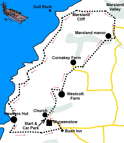
Introduction:
I was actually staying in North Devon and writing about walks there when I
strayed over the border into North Cornwall for this walk. It starts in the
hamlet of Morwenstow with its church and its unusual roof and memorial to
sailors then proceeds through the countryside before emerging on the coast
path and following an attractive stretch of coast to Hawkers Hut before
returning to Morwenstow.
Although the walk is not
especially long, there are three very steep descents/ascents on the coast
path hence the red traffic light.
There is free parking at a
National Trust outside the Refectory Tea Rooms. To get to Morwenstow, turn
off the A39 about half way between Clovelly and Bude.
Start:
With your back to the Refectory Tea Rooms facing the church, take the
footpath opposite (not the one going left). Go through the church lych gate
into the churchyard. The church is worth a look for its roof which inside
looks like the hull of an upturned boat. On the left as you walk to the
church door is an unusual monument to the sailors of a brig Caledonia who
perished 7 September 1842. It is a replica of the figurehead (the original
is in the church).
%20Morwenstow%20Church.jpg)
%20Monument%20to%20Caledonia%20crew.jpg) Immediately through the
lych gate is a railed path which is your route. Follow it down turning right
and as the rail runs out, turn right and immediately left down towards the
vicarage.
Immediately through the
lych gate is a railed path which is your route. Follow it down turning right
and as the rail runs out, turn right and immediately left down towards the
vicarage.
Pass the vicarage and walk
down through the trees, ignoring a left turn for the coastal path. After
crossing a footbridge and coming out into a field, go straight ahead,
ignoring the path to the left.
Go through a gateway at the
top of the field. The official footpath turns right at a gate to go through
the farmyard to Westcott but an alternative route has been provided so that
you can avoid the hazards of the farmyard. Take this alternative path ahead
to a stile with wooden steps at the top of the field (SS 206158). Cross this
and turn right.
As you emerge at the farm,
avoid following the concrete farm track by mistake and turn left through a
gate indicated by a footpath arrow (SS 208158). Follow this to the road and
turn left.
You soon come to Cornakey
Farm where another alternative path guides you round the farm to the right
of a wooden barn. Go through the walkers gate in the hedge on the left and
turn right on the track (SS 211162).
The next section of the
walk to Marsland manor is clearly marked with footpath arrows and via yet
another alternative route, exits into a road. Turn left here past the manor.
Walk along the road for 100
yards or so and as it bends sharply right, you continue straight ahead on a
broad track (SS 218169) signposted to Marsland Mouth. There is also a green
footpath arrow indicating the way to the coastal path.
As the track bends right,
there is a notice telling about the Marsland Valley with details of a short
circular walk should you wish to visit it. Feel free but otherwise, turn
left at this notice indicated by the yellow footpath arrow, Go through a
kissing gate and take the left path.
You reach the coastline
above Marsland Mouth joining the coastal footpath at SS 211173. Turn left.
%20Marsland%20Mouth.jpg)
%20Dramatic%20Rock%20strata.jpg)
%20Rock%20Arch.jpg)
It is now a case of simply
following the coast path including the three steep ascents/descents – but
I was kind bringing you out at the top of Marsland Mouth avoiding a fourth!.
You pass a metal bench and a notice advising about visiting the Bush Inn
(you will pass this later). The church and vicarage at Morwenstow appear on
the left.
You reach Hawkers Hut (SS
199152) indicated by a National trust sign on a piece of slate but to see
it, you need to go down a few steps. It seems the Reverend R.S. Hawker had
this hut built from driftwood
and timber from wrecked ships round about the 1840s and spent time here in
contemplation and smoking opium! It is the smallest property belonging to
the National Trust and although it has been maintained, much of the original
remains. There are some old carvings on the walls.
%20Coast%20Near%20Hawkers%20Hut.jpg)
%20Hawkers%20Hut.jpg)
Back on the coast path,
continue beyond Hawkers Hut and after going through a kissing gate (SS
199150), turn immediately left to follow the wall. I was shocked (sorry!) to
find an electric fence here at the time of my visit but there was
fortunately an insulated bar to lift to pass through.
The footpath becomes a wide
farm track lined with hedges which leads you to the centre of the hamlet
Crosstown by the Bush Inn – which thankfully was open all day at the time
of my visit! With the pub at your back, turn left and follow the road back
to your starting point.
If you need to buy any hiking
equipment/clothing before your trip see the Hiking
Store
All information on this
site is given in good faith and no liability is accepted in respect of any
damage, loss or injury which might result from acting on it.
|


.jpg)
.jpg)
.jpg)