
|
|
|
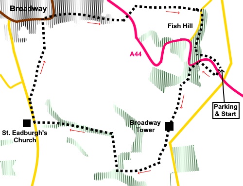
To view route as a dynamic Ordnance Survey map click here. Introduction: This fairly short, easy walk takes you from Fish Hill/Broadway Beacon Hill past Broadway Tower and round through Broadway itself. The tower stands on Broadway (or Beacon) Hill, which, at 1027ft (313m) is the second highest hill in the Cotswolds after Cleeve Hill. Not surprisingly, its height in the landscape provided an ideal place for beacon bonfires. Unfortunately, its height also made it a hazard for aircraft and in 1943, a Whitley bomber on a training mission crashed into, it killing all the crew. A memorial to them is passed on the walk. The 65 foot Broadway Tower is an 18th Century folly built for the 6th Earl of Coventry of nearby Croome Court. It was completed in 1798. It is a mixture of architectural styles from battlements to French windows. It houses a museum and has a great vantage point from its roof. It was disappointing to discover it wrapped in scaffolding and sheeting, due to renovation work but I have discovered a picture I took of it some years ago, to give you the full effect. My walk drops down to the 12th Century St. Eadburgha’s Church, just outside the village of Broadway. This is dedicated to the grand-daughter of King Alfred the Great. It is Broadway’s only Grade I listed building. Its tower is 15th Century. If you are looking for a picnic stop, there is a handy seat at the entrance to the churchyard. We then progress to Broadway itself. It was one of the six new market towns founded after the Norman Conquest but its true origins are uncertain. Archaeological finds suggest it could be over 5000 years old. It takes its name from the wide main street, now called High Street. It was on a toll road and an important stagecoach stop on the main road from London to Worcester from the early 18th Century and displays a prominent sign to celebrate the fact. Fish Hill from which the walk starts was a steep incline for stagecoaches and extra horses often had to be hitched up. Today, it is a very upmarket town catering for relatively wealthy shoppers, with plenty of bars/cafes etc. This has made the bulk of the High Street somewhat ‘twee’. However, the section High Street my route uses, is a dead end (for cars) section and in my opinion the best part, with some beautiful buildings. The walk starts from the Fish Hill picnic area, about one and three quarter miles south east of the roundabout linking the A44 and B4632. Turn off the A44, following the sign for “Picnic Area”, “Farncombe Estate” and “Saintsbury 2 miles”. The picnic area is on the left after a short distance. Note you cannot access the parking area direct from the A44. Start: From the car park (SP 120369), take the footpath alongside the information boards, opposite the toilets. You will quickly pass a fingerpost for the “Cotswold Way” and “Broadway 2 miles”.
Cross the A44 very carefully as it is a busy, fast road. Once across, turn right along its wide verge and after fifty yards or so, turn left following the “Cotswold Way” fingerpost, along a tarmac cul-de-sac. Just past the house named “The Fish”, the tarmac ends and you follow a rough stony track/footpath, which curves left through the trees, where there are posts with yellow arrows marking the way.. The footpath emerges on to a grassy hillside in what almost looks like a grassy ditch. Follow it along to a great viewpoint and ahead is Broadway Tower.
Go through the metal gate by the tower and follow the gravel path, along the ridge. At SP114361 you pass the memorial referred to in the introduction.
Continue along the ridge to another set of metal gates where you follow another gravel path into the car park, passing a café. Exit the car park, turning right down the tarmac lane (SP 113358). Note the proliferation of “No Entry” signs relates to the land at the other side of the fence. The lane is public access. Stay on the lane past some houses, then turn right following a sign for “Shepherds Huts Pods and Cabin”. Shortly after this sign is a yellow arrow on a post. To guide you. Go through a metal gate and turn 90° right. Follow the obvious path downhill, which curves left in front of a stone built bungalow (SP 107359). After going through another metal gate, arrive at a junction of paths. There is a post bearing multiple arrows. Turn left, descending a broad track (SP 107361). This is marked on the 1:25000 map as Coneygree Lane. Follow this down to the road and turn right. St. Eadburgha’s Church is immediately on the left.
Continue along the road. It is quite busy but there are some good verges to keep you out of the traffic. Not far after the village sign for Broadway, look out for a public footpath fingerpost on the right. It is set back, on the left of a drive. There is a sculpture of a head in the wall! Go through the walker’s gate following the fingerpost (SP 097365). The field were marked out for horse trials. I am not sure whether these are permanent, but they clearly directed walkers anti-clockwise round the edge of the field. The footpath path into Broadway is well marked via gates, signs and trodden path. Emerge in the main street opposite the Horse and Groom pub. Turn right along the high Street. At the mini roundabout, keep straight ahead. You will soon pass the sign indicating the coaching route.
The road ands at a turning circle for cars but continue along the old road. After a hundred yards or so, turn left to follow a public footpath fingerpost and pass under the A44 (SP 109375). Once under the road, ignore the right turn to “The Fish” and stay on the broader track climbing the hill, following a fingerpost for “Chipping Campden”. The track bends sharply left after a few yards then right to follow the hedge (SP 110377). It is marked with a yellow arrow. Stay on the broader track between the trees, ignoring a fainter path off to the left. The track continues in a fairly straight line, climbing gently.
Emerge on to the road by a sign for Foxhill Manor. Cross the road and follow the fingerpost to “Fish Hill Picnic Area”. The route is a bit indistinct at the start but you should spot a building with a curved roof on the skyline above the trees. The route turns right here, below the building and keeping below the top of the banking. Once you get going, the path is fairly clear on the ground, though there are a lot of tree roots to negotiate. You reach a point where the path divides, marked by arrows on posts. Keep to the higher level path. Climb some rough steps then very shortly descend some. And join a path at a ‘T’ junction. Turn left. It is marked with a yellow arrow. You reach the A44 but as you do, the path cuts back left to stay in the trees. At another junction of paths, keep right. Reach a viewpoint with topograph at SP 118371. Descend the steps from the topograph and continue in the same direction, ignoring a path on the left and return to the car park.
If you need to buy any hiking equipment/clothing before your trip see the Hiking Store All information on this site is given in good faith and no liability is accepted in respect of any damage, loss or injury which might result from acting on it.
| | |||||||||||||||||

.jpg)
.jpg)
.jpg)
%20Tree%20planting%20in%20the%20old%20quarry.jpg)
%20View%20over%20the%20Vale%20of%20Evesham.jpg)
%20Broadway%20Tower%20under%20wraps.jpg)
%20Broadway%20Tower%20unwrapped.jpg)
%20View%20from%20Broadway%20Hill.jpg)
%20Memorial%20to%20RAF%20Bomber%20crash.jpg)
%20St.%20Eadburgha's%20church.jpg)
%20Quiet%20end%20of%20High%20Street,%20Broadway.jpg)
%20Pretty%20Cottages,%20Broadway.jpg)
%20Sign%20indicating%20the%20ols%20coaching%20route.jpg)
%20View%20climbing%20Fish%20Hill.jpg)
%20Topograph%20on%20Fish%20Hill.jpg)
%20View%20NE%20from%20the%20topograph.jpg)