
|
|
|
To view route as a dynamic Ordnance Survey map click here. Introduction: This walk takes you from the insanely attractive Chipping Campden to the superb, 755ft (230m) vantage point of Dover’s Hill with a clear view over the Vale of Evesham. Chipping Campden is also insanely packed with parked cars and I strongly recommend doing this walk at a weekend if possible, when you are allowed to park on Chipping Campden school car park – signposted. There was plenty of room when I parked there. There is a donations box. Chipping Campden is built of the honey-coloured Cotswold stone which makes the area unique. In the centre of the town is the ancient Market Hall which was built in 1627. There are gorgeous buildings, too numerous to mention but one is Grevel’s House which was built in the 14th Century! “Chipping” comes from Old
English meaning “ceapen”, a market place. There is known to have been a
settlement here since the 7th Century. It got its Market Charter
in 1185. The town rose to prominence between the 13th and 15th
Centuries, as a producer of wool for export but exports declined as weaving
in this country increased but the area did not have enough water to power
the machinery. The town briefly prospered as a silk producer but this too
declined. Agriculture also hit a slump and the town became run down and half
empty. In 1902, C R Ashbee and his
Guild of Handicraft moved to the town. The Guild only lasted about five
years but the craftsmen stayed. In 1904, F. L. Griggs, a well
known etcher and architect moved to the town and began doing conservation
work. Ultimately, a trust was formed and many properties were restored. It
is largely thanks to these two that the town is as attractive as it now is. Dover’s Hill is part of a
ridge to the west of Chipping Campden separating the valley in which the
town sits from the vale of Evesham. From the top, there are extensive views.
On a clear day, you can reputedly see the Malvern Hills but I was not
blessed! The ridge
forms a sort of amphitheatre, facing west. On the Friday after Spring Bank
Holiday, the Cotswold Olimpick Games
are held on this hill. The sports include morris dancing and tug-of-war but
also shin kicking so I am glad I missed it! Descending from Dover’s Hill, my route goes
through the churchyard of the unusually named Weston-sub-Edge, coming out in
a field with various lumps and bumps. These are the remains of a 17th
Century, moated manor house. Usually, when these types of things are shown
on maps, there is little to see when you get there but there is no mistaking
these. Chipping Campden is best approached via the
B4035, which runs from Banbury to Evesham. Chipping Campden School is at the
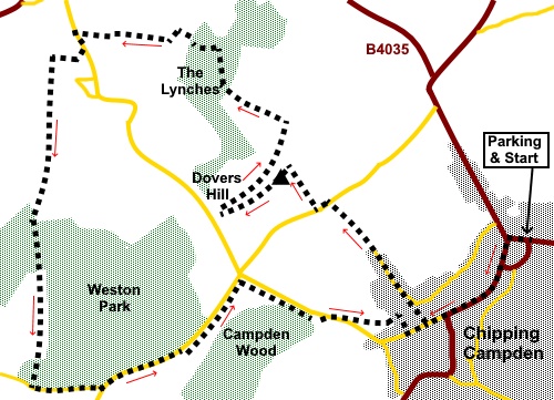
northern end of the town and the parking there is signposted. Start: Turn right out of the school and follow the road (Cidermill Lane) to the road junction and turn left. Although the road you join is, at this point called Leysbourne, it becomes the High Street.
Follow it along, enjoying the architecture and Market Hall until you get to St. Catharine’s Church and Primary School. Turn right immediately after this along Hoo Lane. There is a sign for the Cotswold Way on a wall.
At the junction with Back Ends, stay on Hoo
Lane, following a Cotswold Way fingerpost. Eventually the tarmac gives way to a rough stony track. Continue along this until, you reach the road. Turn left along it for about a hundred yards then turn right off it following a fingerpost for “Cotswold Way”, “Public Footpath” and “Dovers Hill”.
Go through a kissing gate and turn left, indicated by a blue bridleway arrow. You soon reach the trig. point at SP 140399.
Continue along the ridge to the topograph (SP 137397). Between the trees are good views over the Vale of Evesham.
Just beyond the topograph, the onward route goes down a grassy ‘gully’. Ay the bottom of it, turn right to walk along the broad flat area just below the ridge. Continue, following the curve of the ridge above you until you arrive at two kissing gates (SP 141402). Do not go through either but turn left to follow the fence down to the trees. Go through a kissing gate and turn right to follow the Cotswold Way through the trees (The Lynches). After a few yards, the path divides and there are some yellow arrows but ignore this and follow the main track through the trees. There are occasional arrows to guide you and you cross a wooden walkway over a boggy area. The path drops down to a ‘T’ junction. Here you must turn right, ignoring the temptation of paths and arrows encouraging you left! You leave the Cotswold Way here.
Cross a stile and follow the hedge on the left, turning left at the corner. The path leads to a fence where you turn right through a narrow band of trees. Emerge into a children’s play area and head for a spot about half way along its right hand boundary and cross a stile. Bear left to the diagonally opposite corner of the field. At the road, turn left to the Church of St. John the Baptist and St. Lawrence turn right through the churchyard where there are some handy benches for a picnic. It is worth a look in the church because it has some super stained glass.
Continue through the churchyard and out of the gate at the back. You enter the field where the outline of the remains of the moated manor house are clear. Negotiate your way right-ish to the diagonally opposite corner of the field. Cross a stile and go through the farm gate opposite. Join a broad track and turn left. As the track bends right, go left, to the stream and cross a stile, to follow the left hand boundary of the field. In effect you now follow the stream for just over half a mile, as follows, until you reach some trees. Cross a stile in the top left hand corner of the field and cross the stream via a footbridge. At a four way fingerpost (SP 126398), keep straight ahead. You cross the stream again via a footbridge and turn left. On leaving the trees, enter a large field and follow the left hand boundary and blue bridleway arrow. Briefly through trees again, join a road and turn left. At the road junction turn left again. This section can be quite busy and there is not much of a verge. However, you only have to endure it for about a third of a mile. When the road bend left, look out for a gap in the fence on the right (SP 135389). Go through this and turn immediately left to follow a footpath which is parallel with the road. There are good views here down to Chipping Campden.
At the corner of the field turn right and follow the public footpath fingerpost pointing along the left hand boundary. At the end of the field, the path drops down through some trees to meet the road (SP 142391). Turn right for a few yards along the road then left at a public footpath fingerpost for “C. Campden”. The exit from the field is in the diagonally opposite corner. The field had been recently ploughed and as I did not fancy fighting the corrugations, I walked round the edge! Follow the obvious path from the field. A new development of housing was going on so the future direction of the footpath may change. At the road junction turn right down to High Street and then left to return to the town centre. If you need to buy any hiking equipment/clothing before your trip see the Hiking Store All information on this site is given in good faith and no liability is accepted in respect of any damage, loss or injury which might result from acting on it.
| | |||||||||||||||||

.jpg)
.jpg)
.jpg)
%20Architecture%20in%20Chipping%20Campden.jpg)
%20More%20Chipping%20Campden%20Architecture.jpg)
%20Market%20Hall%20Chipping%20Campden.jpg)
%20Looking%20back%20down%20the%20broad%20track%20from%20Chipping%20Campden.jpg)
%20Looking%20over%20Chipping%20Campden.jpg)
%20Trig.%20Point%20on%20Dovers%20Hill.jpg)
%20View%20over%20the%20Vale%20Of%20Evesham%20from%20Dovers%20Hill.jpg)
%20Topograph%20on%20Dovers%20Hill.jpg)
%20Emerging%20From%20The%20Lynches%20Wood.jpg)
%20St%20John%20the%20baptist%20and%20St%20Lawrence%20Church,%20Weston%20Sub%20Edge.jpg)
%20Stained%20Glass%20in%20Weston%20Sub%20Edge%20church.jpg)
%20Looking%20over%20Chipping%20Campden.jpg)