
|
|
|
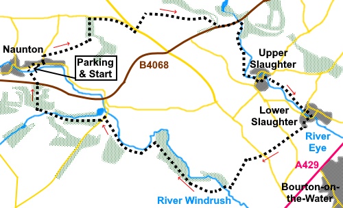
To view route as a dynamic Ordnance Survey map click here. Introduction: Upper and Lower Slaughter, known collectively as ‘The Slaughters’ are quintessentially English villages, which have gained a reputation as a ‘must visit’ destination for tourists visiting the Cotswolds. Certainly they are very attractive but so are many others which live quiet lives, no doubt thankful that the hoards congregate at The Slaughters! They are nevertheless interesting places to visit, particularly the Old Mill at Lower Slaughter. It is worth mentioning that you will see a rather confusing plethora of signs for different name walking ways e.g. Warden’s Way, Windrush Way, McMillan Way, Gloucestershire Way and Gustav Holst Way. These overlap each other. I did not attempt to work out which of these went where and I simply mention them in relation to points on my walk to help you. If you look at the map, you will see that Bourton-on-the-Water is only a stone’s throw from Lower Slaughter. This is even more of a tourist magnet, with, usually, coaches galore crammed with those anxious to see its main street and its stream flowing down it. Having seen it before, I was happy to omit it from my route but if you want to visit, there is a short footpath from Lower Slaughter and you can pick up my route by following the River Windrush north-west out of Bourton. The name ‘Slaughter’ comes not from any murderous connotations but from an Old English name ‘Slough’ or ‘Slothre’, meaning wet land or muddy place, relating to the areas by the rivers on which the villages are situated. Upper Slaughter is a ‘Double Thankful Village’ because it survived both World Wars without losing any of its enlisted men. As you arrive in the village, there is a very pretty ford with footbridge, worth a photo or two. There is also a handy bench with a nice view should you take a pack up lunch. Lower Slaughter is the prime tourist attraction of the two with an attractive area around the village green, river and old mill with a waterwheel. A mill is recorded on the site in the Domesday Book (1086). It became known as ‘Slaughter Mill’ in the 14th Century. It ground flour until 1958 and then fell into disuse. It is currently being restored and at the same time, is a shop, museum, ice cream parlour and café. Naunton
also features in the Domesday Book as ‘Niwetone’.
The River Windrush flows through it, providing attractive water meadows.
Naunton is one of the underrated villages living a quiet life I mentioned
above but it does have a couple of surprises. One is a 16th
Century dovecote, still in use. It was acquired by the Naunton Dovecote
Preservation Society in 1999, thereby disrupting plans to turn it into a
B&B! You are able to look inside it. Evidently the lantern on top, via
which the doves enter/exit is designed to stop hawks getting in. They cannot
cope with the vertical flight needed to get in and out! The other pleasant surprise is the Black Horse pub. I visited
this pub for a meal a year or two ago and the food and beer were excellent. Naunton as a long strung out
village. Parking is on street and the main street can be quite congested. I
parked on a more modern cul-de-sac on the north side of the main street
about half way along. It is named as Village Avenue on maps but did not seem
to have a nameplate. Naunton is situated just off the B4068, which runs from Stow-on-the-Wolds to the A436 east of Cheltenham. Start: From the cul-de-sac (SP 116234), turn left along the main street. Just before the Black Horse pub, turn left at the road junction, following the fingerpost for “Warden’s Way”. After three hundred yards or so, turn right off the road on to a footpath, again following “Warden’s Way” (SP 119236).
The obvious path climbs gently to the diagonally opposite corner of the field and enters the wood. Follow the path through the wood then to the top right hand corner of the next field and in the same direction beyond, following blue bridleway arrows. In the third field after the wood, once more, head for the diagonally opposite corner where you join a broad gravel drive. Keep straight ahead, following a “Warden’s Way” fingerpost and passing through some woodland/shrubbery. A yard or two before reaching the road, turn right through a walker’s gate (SP 127243). This takes you along a footpath which avoids using what seemed to be quite a busy road. Follow this for quite some distance, passing through various fields and gates. Eventually, your way is barred, where you turn left through a gate and cross the road, continuing to follow the “Warden’s Way”. After the road, at the end of the first field on the right, the bridleway turns right, round a barn, following a blue arrow and a footpath sign (SP 136243). Follow it down to the road but a few yards before the road itself, there was a no entry sign next to a gate. On the assumption that if it meant the gate, it would have been attached to it, I went through this field. There was a “Warden’s Way” sign pointing that general direction. The alternative is a fairly unpleasant and potentially dangerous walk along the busy road. However, the field looked to be used for horse jumping, so if this is active or there is other livestock, the road may be unavoidable. At the end of the field, there is a tarmac drive to the road. Just after this, turn right again following another “Warden’s Way” fingerpost (SP 152242). Note if you have gone through the field, turn left at the road then almost immediately right.
The
path now follows the River Eye, on its right hand side to Upper Slaughter,
passing Cress Cottage via a five bar gate to its right, indicated by a blue
bridle way arrow. As you arrive at Upper Slaughter, there is the bench with a view down to the ford, mentioned in the introduction.
Turn right past the phone box, left at the junction, then quickly right to rejoin the river (SP 157232). Cross via the little stone bridge, then right to now follow its left hand bank, following one of two yellow arrows.
Reach
another bridleway/walker’s gate with two arrows. Take the right fork. Emerge in Lower Slaughter by the Old Mill and turn right, following the river. The onward route is over the bridge you soon reach but a wander round this attractive village first is a must.
Once
over the bridge, head up the road opposite. You are now following the
McMillan Way. On reaching the ‘T’ junction (SP 161222), cross straight over on to the obvious path but before the, look back over the fence to the right of the junction, where there is a good view down to Lower Slaughter.
At
the next road, cross over and bearing right follow the sign for the
Gloucestershire Way, heading for the diagonally opposite corner of the
field. At
the corner of the field, go through the walker’s gate and turn left,
following the blue bridleway arrow. The
path drops down to a ‘T’ junction with the Windrush Way. Turn right (SP
151213). Follow the lane down to the river and cross the bridge. Continue
up the hill and turn right following the public bridleway and “Windrush
Way” fingerpost. Just
before the barn at the farm, turn left through the walker’s gate, then
right following the blue bridleway arrow and follow the left hand field
boundary. At
the end of the field, the path curves right, to drop down through the woods
(SP 143214). Part
way through the trees you pass a post mentioning yet another route, the
Gustav Holst Way, as well as the Windrush Way. Not far after this, a path
goes off to the right but ignore this and keep to the more prominent of the
two paths. On
reaching the road by the farm, turn left again following the Windrush Way
fingerpost. Just before the road bends left, look out for a fingerpost on
the right for the Windrush Way and follow the direction of the arrow through
the gate. The
path curves let following the left hand field boundary. It’s is pretty
clear on the ground. Continue
following the path until, after going through a kissing gate you cross the
stream via a large slab of stone and continue up the hill. At the top, turn
right to follow several arrows and the fence on the left. Follow the broad track between the trees and the golf course. It curves left. Ignore a path off to the right. At the road, cross and continue through the gate on the footpath, for no more than two hundred yards. Just before the main path bends left, fork off to the right to descend to Naunton (SP 117233). This is a less obvious path which is easy to miss.
You pass the old dovecote then turn left to reach the main street. If you have parked where I intended, Village Avenue will be opposite.
If you need to buy any hiking equipment/clothing before your trip see the Hiking Store All information on this site is given in good faith and no liability is accepted in respect of any damage, loss or injury which might result from acting on it.
| | |||||||||||||||||

.jpg)
.jpg)
.jpg)
%20Climbing%20up%20from%20Naunton.jpg)
%20Alongside%20the%20river%20Eye.jpg)
%20Footbridge%20at%20the%20ford%20at%20Upper%20Slaughter.jpg)
%20Cottages%20by%20the%20River%20Eye%20at%20Upper%20Slaughter.jpg)
%20Rooftops%20at%20Upper%20Slaughter.jpg)
%20St%20Peters%20Church%20Upper%20Slaughter.jpg)
%20Parish%20Church%20of%20St%20Mary%20Upper%20Slaughter.jpg)
%20Old%20Mill%20at%20Lower%20Slaughter.jpg)
%20Cottages%20by%20river%20Windrush%20at%20Lower%20Slaughter.jpg)
%20Village%20green%20at%20Lower%20Slaughter.jpg)
%20View%20back%20to%20Lower%20Slaughter.jpg)
%20Expansive%20views%20on%20the%20return%20to%20Naunton.jpg)
%20Naunton.jpg)
%20Naunton%20Dovecote.jpg)
%20Inside%20the%20dovecote.jpg)
%20Old%20turbine.jpg)