|
Arnside
Knott Walk
Starting point and OS Grid reference:

Free
seafront car parking at Arnside (SD 454786)
|
Ordnance Survey Map
OL7
The English Lakes - South-Eastern Area.
Buy this map from
List
of OS Maps
Note: If you use OS Maps on-line, you can download this route via this
link.
| |
Distance: 4.9
miles
|
Date of Walk: 27 April 2012
| |
Ascent:
Descent:
See Walking Time Calculator
|
228m (748ft)
227m (743ft)
| |
Traffic
light rating: 
(For explanation see My
Walks page)
| |


For advice on .gpx files see
My Walks page
|

Click
the PDF logo above to give a printable version of this walk without the
photos.
|
To
view route as a dynamic Ordnance Survey map click here.
If you need to buy any
hiking equipment/clothing before your trip see the Hiking
Store
Introduction:
This is a pleasant short stroll
around the coast in an almost forgotten corner of Cumbria and over Arnside
Knott, a low hill behind Arnside village. What is surprising, is the
extensive view from its summit, a very profitable return on a relatively
small effort investment.
The beach part of the walk is a real wide
open spaces experience but a word of warning. There are various signs
warning of fast rising tides, quicksands and hidden channels. They also
advise that warning sirens will sound to warn of the approaching tide. The
route described is safe (I survived!) as long as the warnings are heeded and
if the speed of a tide justifies a siren, it needs to be respected!
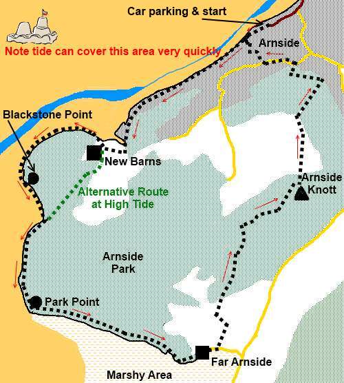
The walk starts from the promenade road where
there is free parking (SD 454786).
Refreshment possibilities are at Bobs Cafe at
New Burns and pubs at Arnside on return.
To get to Arnside, turn west off the A6 at
Milnthorpe (north of Carnforth) and simply follow the B5282.
Start:
Facing the beach, turn left and walk along the promenade. As you reach
the end of the road, follow the green sign indicating “Footpath to New
Barns Bay”. The route runs along the back of the beach on a concrete path.
Also, pass a fingerpost for New Barns. The town of Grange over Sands is
across the beach and it looks as though you could stroll across when the
tide is out – but don’t try!!!
%20View%20over%20Milnthorpe%20Sands.jpg)
%20View%20over%20estuary%20towards%20Grange-over-Sands.jpg)
You approach an area of grassed over mud (SD
444779), which sounds uglier than it is. The path runs around the back of
this and there is a sign for the “Bob In Cafe” which is at New Barns,
the small collection of buildings across the grassy area
(SD 442778).
On reaching New Barns, there is a three way
finger post. Assuming the tide is favourable, take the route to Blackstone
Point, otherwise take the alternative route to Whitecreek and Far Arnside.
This alternative route runs to the landward side of Frith Wood and rejoins
the coastal path at Arnside Point.
%20Blackstone%20Point.jpg)
%20Wide%20Open%20Spaces.jpg)
%20Rocky%20Ramp.jpg)
After rounding Blackstone Point
(SD 437776), there is a small bay. Depending on the state of the tide you
can either walk along the beach or there is a clear footpath along the low
cliffs. Assuming the beach route (as I did), there is a convenient natural
rock ramp at the far side of the bay to climb to the cliff top route. It is
recommended to leave the beach at this point.
Walk along the clear cliff path, rounding
Park Point (SD 438767) until you get to the residential caravans. Take the
main tarmac road through the caravan park following the public bridleway
fingerpost for Far Arnside.
Walk through the hamlet of far Arnside and
turn left off the road at the three way green fingerpost for “Arnside via
the Knott” (SD 438767).
The fenced footpath takes you to a stone slit
stile by another caravan site. Turn left following the public footpath
fingerpost for Arnside (SD 451764).
You enter the national Trust area of
Heathwaite. Follow the obvious climbing track. Glimpses of the distinctive
shape of Ingleborough in the Yorkshire Dales appear in the distance.
%20Looking%20Towards%20Silverdale%20from%20Park%20Point.jpg)
You arrive at a four way fingerpost. Go
through the walkers’ gate next to it and go straight ahead, following the
direction for “Arnside Knott”. When the track forks, go right. Views to
the Lake District hills start to unfold. Keep ahead on the main climbing
track ignoring any turns off.
%20View%20North%20From%20Arnside%20Knott.jpg)
%20View%20Esat%20From%20Arnside%20Knott.jpg)
%20Trig%20point%20at%20Arnside%20Knott.jpg)
The main track misses the trig. point but if
you want to find it, just as you approach a bench comprising a seat between
stone pillars, bear right on a grassy track. The white trig point is to the
left after 100 yards or so (SD 456775).
Return to the main track. It forks at a
walkers’ gate. Ignore the right hand fork following the wall and turn left
through the gate. Descend the field to its bottom right hand corner. Go
through the gate into the woods and turn left.
At the road, turn left and follow it as it
curves right. At the road junction, turn left and walk along the road until
you see a “no through road” on the right. It displays no name but there
is a fingerpost indicating a public footpath to the Promenade. Follow the
road downhill then the narrow footpath at its end. It brings you to the
concrete path along the foreshore where you started. Turn right back to
Arnside.
All information on this
site is given in good faith and no liability is accepted in respect of any
damage, loss or injury which might result from acting on it.
|


.jpg)
.jpg)
.jpg)