
|
|
|
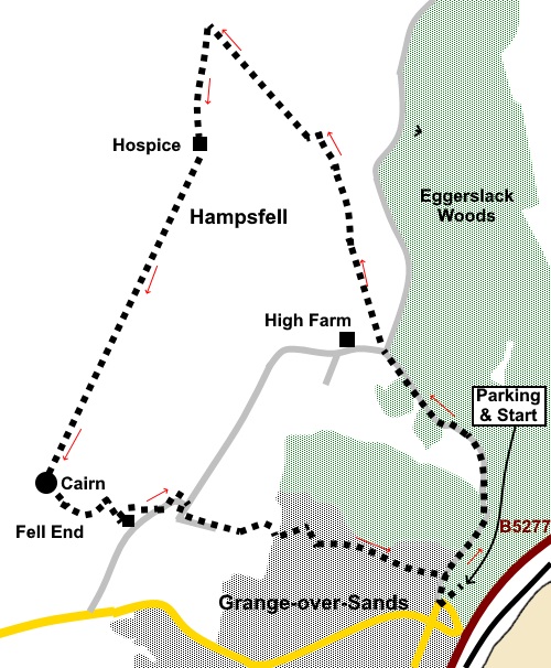
To view route as a dynamic Ordnance Survey map click here. Introduction: Hampsfell, above Grange-over-Sands is unusual in these parts in that it has exposed limestone, similar to that seen on my Whitbarrow walk, a little further east. Both are like escapees from the Yorkshire Dales! It is classed as an outlying Wainwright. There are evidently remarkable views from the summit stretching from Blackpool Tower all the way round to the Lake District fells, although when I did the walk on Christmas Eve 2022, the weather was not very clear, when I reached the summit. Hampsfell Hospice is a Grade II listed building and was built by the vicar of Cartmell, Thomas Remington in 1846, to provide shelter for travellers. Inside are stone benches and a fireplace and indeed, there was a bag of firewood ready for anyone in more desperate need than I. It did provide welcome shelter on a cold day for a cuppa! On the side is a rather intimidating stone staircase leading to the roof from where there is (or should be!) good views to the Lake District, with an unusual orientation table, with movable arm and chart to help you identify the individual hills. The steps will probably not suit anyone with vertigo issues. At one time there was not even a handrail! The Greek lettering over the entrance translates as ‘Rosy-fingered Dawn’, a quote from Homer. There are two plaques inside. One is shown in the photo. I will let you read the poem on the other for yourself, when you get there! The walk is easy and the area is a popular with locals and visitors alike. Consequently, there have been multiple paths created by wandering feet. The walk starts from the Hampsfell Road car park in Grange-over-Sands. To get there, turn off at the mini roundabout in the town centre, then first right after St. Paul’s Church. The car park is straight ahead. Start: Walk back along the road and turn right at the junction on to Hampsfell Road. Follow this lane for just over half a mile, ignoring a left turn off. It becomes a stony track which you follow to a ‘Y’ junction with another track. There is a two way fingerpost indicating a ‘Restricted Byway’ to the right. Indeed, you could if preferred take this fractionally longer route by following it for almost half a mile, then left to follow a bridleway at SD 405794).
However, I chose the walker’s gate at this corner, marked with a yellow arrow. Through this, follow the obvious footpath.
Climb a ladder stile and keep straight ahead. There is a path off to the left, going through the rocks, which will take you more directly to the summit but hoping for a slightly longer walk, I continued along the foot of the outcrop, following the contour of the ground, along a visible path.
Arriving at a wall, there was a tumbled down section, which enabled me to pass through (SD 404793), on to Access Land. This might have been a collapsed stile, although it could have been caused by people climbing over. If it gets repaired to a solid wall, the best thing to do would be to retrace your steps and take the path referred to above, through the rocks. Through this wall, there are signs of a footpath. Turn left here heading towards the prominent rocky outcrop ahead (see photo). Just before you get to it, there is a broad grassy track but it is worth going to the outcrop for the view. Turn left along the broad track (SD 403794).
Continue to follow this track through a gate. You soon reach the point where the path passes over the ‘saddle’, between two distinct rocky outcrops (SD 399798). On a clear day, you will get good views towards the Lake District here but I was not so blessed!
Turn left here along a faint path. It quickly joins a broad grassy path turn right along it to follow the broad summit ridge to Hampsfell Hospice at SD 399794), a squat, rectangular building which you will soon see ahead.
There are a number of paths from the Hospice. My route continued straight ahead from the building (i.e. relative to your approach) and fractionally to the right. The broad grassy path continuing along the summit ridge is obvious. When the path divides, fork right. Pass through a gateway and directly ahead, you should be able to make out a cairn at the end of the summit ridge at SD 395783. At the cairn, turn left, heading towards the tiny group of trees, projecting from a rocky outcrop.
Keep to the left of the outcrop and follow the faint path downhill, which follows the line of the rocks on the right, as it curves left. Look out for an opportunity to pass through this line of rocks and head for the reservoir with the small rectangular building on top (see photo).
At the reservoir wall (SD 397882), turn left to follow it and go through the walkers’ gate at its end to join a tarmac lane. Turn left along it. As the lane bends left, keep straight ahead through a small gate and then turn right to follow a yellow arrow to the tarmac drive to a farm. Turn left, again as directed by a yellow arrow. At the farm buildings, follow the footpath signs and cross a stone step stile. Follow the obvious footpath, coming out into a residential area at Ashmount Gardens. Turn left. At the corner, is a short ‘cut through’ footpath which takes you to a lane (Eden Mount). Turn right, downhill. At the junction, turn left (Charney Well Lane). Follow this all the way downhill to the junction with Hampsfell Road, where you turn right to retrace your steps to the car park. If you need to buy any hiking equipment/clothing before your trip see the Hiking Store All information on this site is given in good faith and no liability is accepted in respect of any damage, loss or injury which might result from acting on it.
| | |||||||||||||||||

.jpg)
.jpg)
.jpg)
%20View%20to%20the%20coast%20from%20Hampsfell%20Road.jpg)
%20Fingerpost%20at%20the%20turn%20off%20Hampsfell%20Road.jpg)
%20View%20to%20Arnside%20Knott.jpg)
%20Crags%20at%20SD%20404791.jpg)
%20Looking%20north%20towards%20the%20Lake%20Disrtict.jpg)
%20Rocky%20outcrop.jpg)
%20View%20between%20outcrops%20to%20Lake%20District.jpg)
%20View%20along%20the%20ridge%20to%20Morecambe%20Bay.jpg)
%20View%20along%20the%20ridge%20to%20the%20Hospice.jpg)
%20Hampsfell%20hospice.jpg)
%20Roof%20of%20hospice%20and%20orientation%20table.jpg)
%20Plaque%20inside%20the%20hospice.jpg)
%20Cairn%20at%20SD%20394783.jpg)
%20Reservoir%20aiming%20point.jpg)